Pennsylvania Route 791
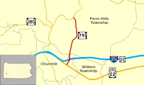
Pennsylvania Route 791 (PA 791) is a state highway located in Penn Hills, Allegheny County, Pennsylvania. It runs 2.10 miles (3.38 km) from U.S. Route 22 Business (US 22 Bus.) in Churchill to PA 380 in Penn Hills. The entire route is part of the Pittsburgh Yellow Belt system of roads. The route runs through a suburban area of Pittsburgh.
| |||||||
|---|---|---|---|---|---|---|---|
 | |||||||
| Route information | |||||||
| Maintained by PennDOT | |||||||
| Length | 2.10 mi[1] (3.38 km) | ||||||
| Existed | 1963–present | ||||||
| Major junctions | |||||||
| South end | |||||||
| North end | |||||||
| Location | |||||||
| Counties | Allegheny | ||||||
| Highway system | |||||||
| |||||||

Route description
PA 791 heads north from the southern terminus on Rodi Road, passing through suburbs.[2] At the terminus, the road continues in both directions as US 22 Business and as part of the Yellow Belt[3] Shortly after the intersection, it heads under Interstate 376 and receives traffic from exit 80. Two miles to the north, it ends at PA 380 in Penn Hills at a shopping plaza.[2]
History
PA 791 was originally assigned as PA 280, along with the remainder of Rodi Road from US 22 Bus. to Thompson Run Road in Wilkins Township, in 1928. The route was decommissioned in 1946 and the northern segment received its current route number in 1963.[4]
Major intersections
The entire route is in Allegheny County.
| Location | mi[1] | km | Destinations | Notes | |
|---|---|---|---|---|---|
| Churchill | 0.00 | 0.00 | Southern terminus of PA 791; southern end of concurrency with Yellow Belt | ||
| 0.26 | 0.42 | No access from PA 791 north to I-376 / US 22 | |||
| Penn Hills Township | 2.10 | 3.38 | Northern terminus of PA 791; northern end of concurrency with Yellow Belt | ||
1.000 mi = 1.609 km; 1.000 km = 0.621 mi
| |||||
See also
 U.S. Roads portal
 Pennsylvania portal
References
- Pennsylvania State Roads - 2010. Harrisburg, Pennsylvania: Pennsylvania Department of Transportation. 2010.
- Pennsylvania Official Highway Map (PDF) (Map) (2010 ed.). Pennsylvania Department of Transportation. Archived from the original (PDF) on 2011-07-20. Retrieved 2010-11-13.
- "Allegheny County Belt System - Yellow Belt". Jeffrey J. Kitsko. March 15, 2010. Retrieved 2010-11-16.
- Pennsylvania Official Highway Map (PDF) (Map) (1960 ed.). Pennsylvania Department of Transportation. Archived from the original (PDF) on 2011-07-05. Retrieved 2010-11-13.
