Plum, Pennsylvania
Plum is a borough in Allegheny County in the U.S. state of Pennsylvania. A suburb of Pittsburgh, Pennsylvania, it is located northeast of the city of Pittsburgh, in what is commonly referred to as the East Hills suburbs. The population was 27,126 at the 2010 census.[3]
- For the township in Venango County, see Plum Township, Pennsylvania.
Plum, Pennsylvania | |
|---|---|
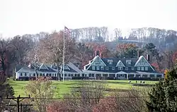 Oakmont Country Club National Register of Historic Places | |
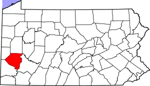
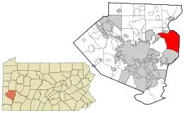 Location in Allegheny County and the U.S. state of Pennsylvania. | |
 Plum Location in Pennsylvania  Plum Location in the United States | |
| Coordinates: 40°29′55″N 79°45′16″W | |
| Country | United States |
| State | Pennsylvania |
| County | Allegheny |
| Founded as Plum Township | 1788 |
| Area | |
| • Total | 28.96 sq mi (75.01 km2) |
| • Land | 28.58 sq mi (74.03 km2) |
| • Water | 0.38 sq mi (0.98 km2) 1.34% |
| Population (2010) | |
| • Total | 27,126 |
| • Estimate (2019)[2] | 27,087 |
| • Density | 947.66/sq mi (365.89/km2) |
| FIPS code | 42-61536 |
| Website | www |
Plum is often referred to as "Plum Boro" or more correctly "Plum Borough" by locals to distinguish it from its previous status as a township. It was founded as Plum Township in 1788 and was reorganized as a borough in 1956. The borough took its name from nearby Plum Creek.[4]
History
Plum Township was founded on December 18, 1788 as one of the original seven townships of Allegheny County. It originally extended as far south as Versailles (modern-day North Versailles Township), east to the county line, west to Pitt Township, and north to the Allegheny River. Plum has shrunk greatly over the years in area, but still remains among the larger municipalities in Allegheny County.[5]
Geography
According to the United States Census Bureau, the borough has a total area of 29.0 square miles (75 km2), of which 28.6 square miles (74 km2) is land and 0.4 square miles (1.0 km2), or 1.34%, is water. Plum Borough is the second largest borough (area-wise) in the state of Pennsylvania.[6]
Streams
- Pucketa Creek joins the Allegheny River where the creek forms the boundary between the borough of Plum and the city of Lower Burrell.[7]
- Abers Creek
- Plum Creek rises in the borough.[8]
- Little Plum Creek
Surrounding communities
- Monroeville (south)
- Penn Hills (west)
- Oakmont (west)
- Harmar Township (north across Allegheny River)
- Cheswick (north across Allegheny River)
- Springdale (north across Allegheny River)
- Lower Burrell (north, in Westmoreland County)
- New Kensington (north, in Westmoreland County)
- Upper Burrell Township (northeast, in Westmoreland County)
- Murrysville (east, in Westmoreland County)
Demographics
| Historical population | |||
|---|---|---|---|
| Census | Pop. | %± | |
| 1960 | 10,241 | — | |
| 1970 | 21,932 | 114.2% | |
| 1980 | 25,390 | 15.8% | |
| 1990 | 25,609 | 0.9% | |
| 2000 | 26,940 | 5.2% | |
| 2010 | 27,126 | 0.7% | |
| 2019 (est.) | 27,087 | [2] | −0.1% |
| Sources:[9][10][11][12] | |||
At the 2010 census there were 27,126 people, 10,528 households, and 7,431 families living in the borough. The population density was 935.4 people per square mile. There were 10,528 housing units at an average density of 363.0 per square mile. The racial makeup of the borough was 93.9% White, 3.6% African American, 0.1% Native American, 1.1% Asian, 0.00% Pacific Islander, 0.2% from other races, and 1.0% from two or more races. Hispanic or Latino of any race were 0.9%.[11]
There were 10,528 households, 29.5% had children under the age of 18 living with them, 62.6% were married couples living together and 29.4% were non-families. 24.5% of households were made up of individuals, and 12.6% were one person aged 65 or older. The average household size was 2.55 and the average family size was 3.09.
The age distribution was 24.2% under the age of 20, 2.5% from 20 to 24, 24.4% from 25 to 44, 29.6% from 45 to 64, and 16.8% 65 or older. The median age was 42.6 years. For every 100 females, there were 97.6 males.
The median household income was $66,680 and the median family income was $74,941. Males had a median income of $54,119 versus $40,625 for females. The per capita income for the borough was $30,474. About 3.8% of families and 4.8% of the population were below the poverty line, including 6.3% of those under age 18 and 3.2% of those age 65 or over.
Government and politics
Boroughs in Pennsylvania (including Plum) are governed by a Mayor-Council system; in which the mayor has only a few powers and the council is the main legislative body.[13] As of January 2020, the mayor is Harry Schlegel.
| Year | Republican | Democratic | Third Parties |
|---|---|---|---|
| 2016 | 58% 8,224 | 41% 5,739 | 1% 121 |
| 2012 | 57% 7,723 | 42% 5,633 | 1% 119 |
Education
The Plum Borough School District serves the borough grades K–12. The elementary schools (grades K–4) are Center and Pivik. The middle elementary school is Holiday Park Elementary (grades 5-6). The junior high school is A.E. Oblock Junior High School (grades 7-8) and Plum Senior High School serves grades 9–12. The latest redistricting was approved by the Plum School Board in 2018. There were once three other elementary schools, which were called Renton Elementary School, Regency Park Elementary, and the other called Adlai E. Stevenson, both have since been torn down. Plum School District is governed by the Plum School Board.[16]
Plum Borough is also serviced by the Plum Borough Community Library. The library houses the history room of the Allegheny Foothills Historical Society (the Historical Society also provides tours of the reconstructed Carpenter Family Log House in Boyce Park).
Landmarks
- Oakmont Country Club is wholly located within Plum's borders, according to Google Maps. The course has been consistently ranked as one of the five best by Golf Digest 100 Greatest Golf Courses in America. In 2007, Oakmont placed 5th by the magazine.[17] It is one of only a few courses ranked every year in the top ten of the publication's history. The top 50 toughest courses rank Oakmont also at #5,[18] while GolfLink.com ranks it at #3 overall.[19] It hosted its ninth U.S. Open in 2016, the most of any course.
- The portion of the Pennsylvania Turnpike from mile markers 49 through 55 crosses through Plum.[20]
Notable people
- William D. Boyce, founder of the Boy Scouts of America
- Pat McAfee, former punter for Indianapolis Colts, former punter/kicker West Virginia Mountaineers football team
- Elias (real name Jeffrey Sciullo), professional WWE wrestler
See also
References
- "2019 U.S. Gazetteer Files". United States Census Bureau. Retrieved July 28, 2020.
- "Population and Housing Unit Estimates". United States Census Bureau. May 24, 2020. Retrieved May 27, 2020.
- "Race, Hispanic or Latino, Age, and Housing Occupancy: 2010 Census Redistricting Data (Public Law 94-171) Summary File (QT-PL), Plum borough, Pennsylvania". United States Census Bureau. Retrieved September 21, 2011.
- Porter, Thomas J. Jr. (May 10, 1984). "Town names carry a little bit of history". Pittsburgh Post-Gazette. p. 1. Retrieved 26 May 2015.
- Kordalski Jr., Frank (May 16, 2011). Plum Borough. Arcadia Publishing. ISBN 9780738574332.
- "About the Borough of Plum | Plum PA". www.plumboro.com. 2013-06-03. Retrieved 2018-04-20.
- "Pucketa Creek". Geographic Names Information System. United States Geological Survey. Retrieved 2009-12-02.
- "Plum Creek". Geographic Names Information System. United States Geological Survey. Retrieved 2010-12-18.
- "Number of Inhabitants: Pennsylvania" (PDF). 18th Census of the United States. U.S. Census Bureau. Retrieved 22 November 2013.
- "Pennsylvania: Population and Housing Unit Counts" (PDF). U.S. Census Bureau. Retrieved 22 November 2013.
- "U.S. Census website". United States Census Bureau. Retrieved 2008-01-31.
- "Annual Estimates of the Resident Population". U.S. Census Bureau. Archived from the original on 19 October 2013. Retrieved 22 November 2013.
- "Plum Boro: Government". Retrieved 25 January 2020.
- EL. "2012 Allegheny County election". Pittsburgh Tribune-Review. Retrieved 15 October 2017.
- EL. "2016 Pennsylvani general election..." Pittsburgh Post-Gazette. Retrieved 15 October 2017.
- Divittorio, Michael (March 2, 2018). "Plum School District reconfiguration options to be narrowed down at committee meeting". Pittsburgh Tribune-Review.
- "America's 100 Greatest Courses". Golf Digest. May 2007. Archived from the original on 2007-06-07. Retrieved 2007-06-10.
- "America's 50 Toughest Golf Courses". Golf Digest. March 2007. Archived from the original on 2013-01-11. Retrieved 2007-06-10.
- "Top 100 United States Golf Courses". Golf Link. 2007. Retrieved 2007-06-10.
- "About Unity Volunteer Fire Department". 2009. Retrieved 2009-09-12.
External links
| Counties |  Map of the Pittsburgh Tri-State with green counties in the metropolitan area and yellow counties in the combined area | |
|---|---|---|
| Major cities | ||
| Cities and towns 15k–50k (in 2010) | ||
| Airports | ||
| Topics | ||
| ||

| Authority control |
|---|