Philadelphia and Lancaster Turnpike
The Philadelphia and Lancaster Turnpike, first used in 1795, is the first long-distance paved road built in the United States, according to engineered plans and specifications.[3] It links Lancaster, Pennsylvania, and Philadelphia at 34th Street, stretching for sixty-two miles. It was later extended by the Lancaster and Susquehanna Turnpike to the Susquehanna River in Columbia.[4] The route is designated Pennsylvania Route 462 from the western terminus to US 30, where that route takes over for the majority of the route. The US 30 designation ends at Girard Avenue in the Parkside neighborhood of Philadelphia, where State Route 3012 takes it from there to Belmont Avenue. At Belmont Avenue, State Route 3005 gets the designation from Belmont Avenue until the current terminus at 34th Street. Historically, Lancaster Pike terminated at Market Street before Drexel University took over the stretch between 32nd and 34th Streets.[5]
| Philadelphia and Lancaster Turnpike | |
|---|---|
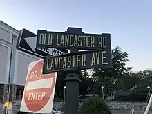
| Lancaster Avenue | |
| Route information | |
| Maintained by PennDOT | |
| Length | 73.33 mi[1] (118.01 km) Route to Columbia included (10.86 mi) |
| Existed | 1792 (first used 1795)–present |
| Component highways |
• SR 3012 and SR 3005 in Philadelphia • Lancaster Walk (a pedestrian walkway) in Drexel University campus between 34th and 32nd Streets • Lancaster Avenue between 32nd and Market Streets |
| Major junctions | |
| West end | |
| East end | 34th Street in Philadelphia |
| Location | |
| Counties | Lancaster, Chester, Delaware, Montgomery, Philadelphia |
| Highway system | |
| |
| Designated | November 20, 1999[2] |
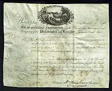
It was the first turnpike of importance, and because the Commonwealth of Pennsylvania could not afford to pay for its construction, it was privately built by the Philadelphia and Lancaster Turnpike Road Company, making it an early example of a public-private partnership for American infrastructure.[6][7] Credited as the country's first engineered road, its ground was broken in 1792.[8] By the 1840s, the use of railroads and canals dealt a serious blow to the companies who specialized in the manufacture of wagons and coaches. During the next fifty years, the road suffered from lack of use and maintenance, but later saw recovery with the invention of the automobile.
In 1876, the parallel Pennsylvania Railroad bought the turnpike from 52nd Street in Philadelphia west to Paoli for $20,000 (equal to $480,188 today) to prevent competing streetcar companies from building along it. In 1913, the turnpike became part of the transcontinental Lincoln Highway, and tolls continued to be collected until 1917, when the State Highway Department bought it for $165,000, equal to $3,292,714 today.[9] In 1926 it was designated as part of U.S. Route 30 along with the rest of the original United States Numbered Highways.
Major intersections
| County | Location | mi[1] | km | Destinations | Notes |
|---|---|---|---|---|---|
| Lancaster | Columbia | 0.00 | 0.00 | Western terminus of the former Turnpike. 40.033907°N 76.504755°W PA 462 continues west into Wrightsville on the Columbia-Wrightsville Bridge. | |
| Lancaster Township | 7.73 | 12.44 | |||
| Lancaster | 9.76 | 15.71 | Western terminus of westbound concurrency with PA 23 westbound. | ||
| 10.48 | 16.87 | Eastern terminus of PA 999. Connection to King Street only.[10] | |||
| 10.74 | 17.28 | Southbound one-way pair of US 222/PA 272. | |||
| 10.86 | 17.48 | ||||
| 11.10 | 17.86 | Northbound one-way pair of US 222/PA 272. | |||
| 11.84 | 19.05 | Eastern terminus of westbound concurrency with PA 23 westbound. | |||
| 12.74 | 20.50 | Western terminus of PA 340. | |||
| East Lampeter Township | 14.54 | 23.40 | Eastern terminus of PA 462. Turnpike is designated US 30 east of this point. | ||
| Ronks | 17.03 | 27.41 | |||
| Gap | 25.92 | 41.71 | Eastern terminus of PA 772. | ||
| 26.32 | 42.36 | Northern terminus of PA 41. | |||
| 26.66 | 42.91 | Southern terminus of PA 897. | |||
| Chester | West Sadsbury Township | 31.10 | 50.05 | ||
| 31.50 | 50.69 | Western terminus of US 30 BUS. Turnpike is US 30 BUS east of here. | |||
| Coatesville | 36.59 | 58.89 | |||
| 37.00 | 59.55 | ||||
| Thorndale | 41.24 | 66.37 | Eastern terminus of PA 340. Paoli/Thorndale Line trains terminate here at the nearby train station, two intersections west at S. Bailey Rd. | ||
| Downingtown | 43.48 | 69.97 | Western terminus of concurrency with US 322. | ||
| 43.66 | 70.26 | Eastern terminus of concurrency with US 322, western terminus of concurrency with US 322 Truck | |||
| 43.80 | 70.49 | Eastern terminus of PA 282. | |||
| 44.18 | 71.10 | Southern terminus of PA 113. | |||
| East Caln Township | Eastern terminus of concurrency with US 322 Truck | ||||
| 45.41 | 73.08 | Interchange. | |||
| Exton | 47.98 | 77.22 | |||
| West Whiteland Township | 50.29 | 80.93 | Eastern terminus of US 30 BUS. Turnpike is US 30 east of here. | ||
| Frazer | 51.65 | 83.12 | Northern terminus of PA 352. | ||
| Malvern | 53.21 | 85.63 | Eastern terminus of PA 401. | ||
| 53.62 | 86.29 | Southern terminus of PA 29. | |||
| Paoli | 56.14 | 90.35 | |||
| Delaware | Villanova | 62.93 | 101.28 | Interchange. | |
| 63.26 | 101.81 | ||||
| Montgomery–Philadelphia county line | Lower Merion Township–Philadelphia line | 69.35 | 111.61 | ||
| Philadelphia | Philadelphia | 71.56 | 115.16 | US 30 is the Turnpike west of here. Western terminus of SR 3012. | |
| 72.00 | 115.87 | Belmont Avenue (SR 3005) / 44th Street | Eastern terminus of SR 3012. Concurrent with SR 3005 until terminus.[5] | ||
| 73.04 | 117.55 | ||||
| 73.33 | 118.01 | 34th Street | Eastern terminus of SR 3005. 39.958767°N 75.191009°W | ||
| 73.83 | 118.82 | Drexel University | Pedestrian walkway called “Lancaster Walk” | ||
| 74.33 | 119.62 | Eastern terminus of “Lancaster Avenue” at Market Street Location of 32nd St. and Lancaster Ave. Philadelphia Armory 39.9553841°N 75.1875208°W | |||
1.000 mi = 1.609 km; 1.000 km = 0.621 mi
| |||||
See also
 U.S. Roads portal
 Pennsylvania portal
 Philadelphia portal
- Great Wagon Road
- Lincoln Highway
- "The Colossus", 1813 bridge
References
- DeLorme Street Atlas 2007, Toggle Measure Tool. Retrieved on July 2, 2007.
- "PHMC Historical Markers Search" (Searchable database). Pennsylvania Historical and Museum Commission. Commonwealth of Pennsylvania. Retrieved January 25, 2014.
- "The Philadelphia and Lancaster Turnpike Road". Federal Highway Administration. Retrieved May 29, 2006.
- "Bridges, Roads, and Turnpikes Collection, 1767-1968". LancasterHistory. Retrieved December 10, 2020.
- Philadelphia County (PDF) (Map). Pennsylvania Department of Transportation. 2005. p. 1. Retrieved July 2, 2007.
- Buxbaum, Jeffrey N (2009). Public Sector Decision Making for Public-private Partnerships. Washington, DC: Transportation Research Board. p. 9. ISBN 978-0-309-09829-8.
- "Philadelphia & Lancaster Turnpike". Lifelong Learning Online. Archived from the original on August 27, 2002. Retrieved May 29, 2006.
- "Philadelphia & Lancaster Turnpike". Explore Pennsylvania History. Retrieved May 29, 2006.
- Butko, Brian. The Lincoln Highway: Pennsylvania Traveler's Guide. pp. 50–51. ISBN 0-8117-2497-2.
- "Eastern terminus of PA 999". Google. Retrieved July 2, 2007.
External links
| Wikimedia Commons has media related to Philadelphia and Lancaster Turnpike. |
- Pennsylvania Highways: US 30
- Lancaster Avenue: Turn of the Millennium. Photographs along the Lancaster Turnpike in Philadelphia.