Chester County, Pennsylvania
Chester County (Pennsylvania German: Tscheschter Kaundi), colloquially known as Chesco, is a county in the U.S. state of Pennsylvania. As of the 2010 census, the population was 498,886, increasing by 5.2% to a census-estimated 524,989 residents as of 2019.[2] The county seat is West Chester.[3] Chester County was one of the three original Pennsylvania counties created by William Penn in 1682. It was named for Chester, England.
Chester County | |
|---|---|
| County of Chester | |
 | |
 Flag  Seal | |
 Location within the U.S. state of Pennsylvania | |
 Pennsylvania's location within the U.S. | |
| Coordinates: 39°58′N 75°45′W | |
| Country | |
| State | |
| Founded | August 24, 1682 |
| Named for | Chester, England |
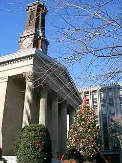
| Seat | West Chester |
| Largest city | West Chester |
| Government | |
| • County commission | |
| Area | |
| • Total | 759 sq mi (1,970 km2) |
| • Land | 751 sq mi (1,950 km2) |
| • Water | 8.7 sq mi (23 km2) 1.1%% |
| Population | |
| • Estimate (2019) | 524,989 |
| • Density | 691.5/sq mi (267.0/km2) |
| Time zone | UTC−5 (Eastern) |
| • Summer (DST) | UTC−4 (EDT) |
| Congressional districts | 5th, 6th |
| Website | www |
| Designated | October 26, 1982[1] |
Chester County is part of the Philadelphia-Camden-Wilmington, PA-NJ-DE-MD Metropolitan Statistical Area. Eastern Chester County is home to many communities that comprise part of the Main Line western suburbs outside of Philadelphia, while part of its southernmost portion is considered suburban Wilmington, along with southwest Delaware County.
History
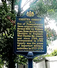
Philadelphia, Bucks, and Chester were the three Pennsylvania counties initially created by William Penn on August 24, 1682.[4][5] At that time, Chester County's borders were Philadelphia County to the north, the ill-defined western edge of the colony (approximately the Susquehanna River) to the west, the Delaware River to the east, and Delaware and Maryland to the south. Chester County replaced the Pennsylvania portion of New Netherland/New York’s "Upland", which was officially eliminated when Pennsylvania was chartered on March 4, 1681, but did not cease to exist until June of that year.[6][7] Much of the Welsh Tract was in eastern Chester County, and Welsh place names, given by early settlers, continue to predominate there.
The fourth county in the state, Lancaster County, was formed from Chester County on May 10, 1729. On March 11, 1752, Berks County was formed from the northern section of Chester County, as well as parts of Lancaster and Philadelphia counties.
The original Chester County seat was the City of Chester, a center of naval shipbuilding, at the eastern edge of the county. In an effort to accommodate the increased population of the western part of the county, the county seat was moved to a more central location in 1788; in order to mollify the eastern portion of the county, the village, known as Turk's Head, was renamed West Chester. In response to the new location of the county seat, the eastern portion of the county separated and formed the new Delaware County in 1789 with the City of Chester as its county seat.[8]
Much of the history of Chester County arises from its location between Philadelphia and the Susquehanna River. The first road to "the West" (meaning Lancaster County) passed through the central part of Chester County, following the Great Valley westward; with some re-alignments, it became the Lincoln Highway and later U.S. Route 30. This road is still named Lancaster Avenue in most of the Chester County towns it runs through. The first railroad (which became the Pennsylvania Railroad) followed much the same route, and the Reading Railroad progressed up the Schuylkill River to Reading. Industry tended to concentrate along the rail lines. Easy transportation allowed workers to commute to urban jobs, and the rise of the suburbs followed. To this day, the developed areas form "fingers" extending along major lines of transportation.
During the American Revolutionary War, the Battle of Brandywine was fought at what is now the southeastern fringe of the county. The Valley Forge encampment was at the northeastern edge.
Geography
According to the U.S. Census Bureau, the county has a total area of 759 square miles (1,970 km2), of which 751 square miles (1,950 km2) is land and 8.7 square miles (23 km2) (1.1%) is water.[9] The topography consists of rolling hills and valleys and it is part of the region known as the Piedmont.
Watersheds that serve Chester County include the Octoraro, the Brandywine, and Chester creeks, and the Schuylkill River. Many of the soils are fertile, rich loam as much as twenty-four inches thick; together with the temperate climate, this was long a major agricultural area. Because of its proximity to Philadelphia, Chester County has seen large waves of development over the past half-century due to suburbanization. Although development in Chester County has increased, agriculture is still a major part of the county's economy, and the number of horse farms is increasing in the county. Mushroom growing is a specialty in the southern portion of the county.
Elevations (in feet): High point—1020 Welsh Mt., Honeybrook Twp. Other high points—960 Thomas Hill, Warwick Twp; 960 Barren Hill, West Caln Twp. Low point—66 Schuylkill River, Chester-Montgomery county line. Cities and boroughs: Coatesville 314; Downingtown 255; Kennett Square 300; Oxford 535; Parkesburg 542; Phoenixville 127; Spring City 114; West Chester 459.[10]
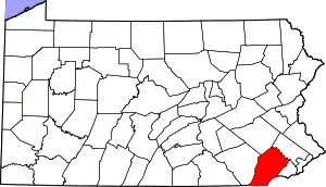
Adjacent counties
- Berks County (north)
- Montgomery County (northeast)
- Delaware County (east)
- New Castle County, Delaware (southeast)
- Cecil County, Maryland (south)
- Lancaster County (west)
National protected area
State protected areas
Economy and environment
Lanchester Landfill, located on the border of Chester and Lancaster Counties, captures methane which is sold for renewable natural gas credits, and piped to seven local businesses. This reduces the county's methane emissions, and provides an alternative to fracking for shale gas.[11]
Demographics
| Historical population | |||
|---|---|---|---|
| Census | Pop. | %± | |
| 1790 | 27,829 | — | |
| 1800 | 32,093 | 15.3% | |
| 1810 | 39,596 | 23.4% | |
| 1820 | 44,451 | 12.3% | |
| 1830 | 50,910 | 14.5% | |
| 1840 | 57,515 | 13.0% | |
| 1850 | 66,438 | 15.5% | |
| 1860 | 74,578 | 12.3% | |
| 1870 | 77,805 | 4.3% | |
| 1880 | 83,481 | 7.3% | |
| 1890 | 89,377 | 7.1% | |
| 1900 | 95,695 | 7.1% | |
| 1910 | 109,213 | 14.1% | |
| 1920 | 115,120 | 5.4% | |
| 1930 | 126,629 | 10.0% | |
| 1940 | 135,626 | 7.1% | |
| 1950 | 159,141 | 17.3% | |
| 1960 | 210,608 | 32.3% | |
| 1970 | 278,311 | 32.1% | |
| 1980 | 316,660 | 13.8% | |
| 1990 | 376,396 | 18.9% | |
| 2000 | 433,501 | 15.2% | |
| 2010 | 498,886 | 15.1% | |
| 2019 (est.) | 524,989 | [2] | 5.2% |
| U.S. Decennial Census[12] 1790-1960[13] 1900-1990[14] 1990-2000[15] 2010-2019[2] | |||
As of the 2010 census, the county was 82.1% White Non-Hispanic, 6.1% Black or African American, 0.2% Native American or Alaskan Native, 3.9% Asian, 0.0% Native Hawaiian, 1.8% were two or more races, and 2.4% were some other race. 6.5% of the population were Hispanic or Latino.
As of the census[16] of 2000, there were 433,501 people, 157,905 households, and 113,375 families residing in the county. The population density was 573 people per square mile (221/km2). There were 163,773 housing units at an average density of 217 per square mile (84/km2). The racial makeup of the county was 89.21% White, 6.24% Black or African American, 0.15% Native American, 1.95% Asian, 0.03% Pacific Islander, 1.35% from other races, and 1.06% from two or more races. 3.72% of the population were Hispanic or Latino of any race. 18.0% were of Irish, 17.3% German, 13.1% Italian, 10.1% English and 5.6% American ancestry. 91.4% spoke English and 3.7% Spanish as their first language.
There were 157,905 households, out of which 35.10% had children under the age of 18 living with them, 60.50% were married couples living together, 8.10% had a female householder with no husband present, and 28.20% were non-families. 22.60% of all households were made up of individuals, and 7.60% had someone living alone who was 65 years of age or older. The average household size was 2.65 and the average family size was 3.15.
In the county, the population was spread out, with 26.20% under the age of 18, 7.90% from 18 to 24, 30.40% from 25 to 44, 23.80% from 45 to 64, and 11.70% who were 65 years of age or older. The median age was 37 years. For every 100 females there were 96.40 males. For every 100 females age 18 and over, there were 93.10 males.
The median income for a household in the county was $65,295, and the median income for a family was $76,916 (these figures had risen to $80,818 and $97,894 respectively as of a 2007 estimate). Males had a median income of $51,223 versus $34,854 for females. The per capita income for the county was $31,627. About 3.10% of families and 5.20% of the population were below the poverty line, including 5.10% of those under age 18 and 5.50% of those age 65 or over.
The region was originally occupied by the Lenni Lenape people, who greeted European settlers in the seventeenth century with amity and kindness. British settlers were mostly English, Scotch-Irish and Welsh in ethnicity. From the late 19th to early 20th century, the industrial areas of the region, such as Coatesville, attracted immigrants and job seekers from Germany and Ireland, Eastern Europe, Italy, and the American rural South, with both black and white migrants coming north. Later Hispanic immigrants have included Puerto Ricans and, most recently, Mexicans.
Long a primarily rural area, Chester County is now the fastest-growing county in the Delaware Valley; it is one of the fastest growing in the entire Northeastern section of the United States.
Religion
In keeping with its colonial history, Chester County is home to a number of historic Quaker buildings, including Birmingham, Birmingham Orthodox, Bradford, Caln, Old Kennett, Parkersville, Westtown, and Uwchlan meeting houses. Other historic religious buildings include St. Malachi Church, southeastern Pennsylvania's oldest active Catholic mission church, and the Episcopal St. Mary's, St. Paul's, and St. Peter's churches, and Washington Memorial Chapel. Also located in the county are the First Presbyterian Church of West Chester, Coventryville United Methodist Church, which is part of the Coventryville Historic District, and Beth Israel Congregation of Chester County, a Conservative synagogue in Coatesville, a site of Eastern European immigration in the 20th century.
Politics
- Election results
As of 14 September 2020, there are 366,408 registered voters in Chester County.[17]
- Democratic: 152,550 (41.63%)
- Republican: 150,216 (41.00%)
- Other Political parties and no affiliation: 63,642 (17.37%)
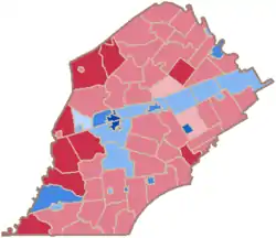
Chester County has historically been reliably Republican at the county level; traditionally, it was the most conservative county in the Philadelphia area. In recent elections, however, it has been trending Democratic, though not as overwhelmingly as the rest of the Philadelphia suburbs. In 2000 Al Gore lost it by almost 10 percent but in 2004 George W. Bush defeated John Kerry by a much smaller margin of only 4.5 percent. Bob Casey, Jr. carried it by 10% when he unseated incumbent Republican US Senator Rick Santorum in 2006. In 2008, Chester County sided with the rest of Pennsylvania and voted for Barack Obama by a much larger margin of 9%, making him the first Democrat to carry it in a Presidential election since 1964. But, in 2009, with a smaller turnout, Republican candidates swept all county-row offices, winning with an average margin of 20%. In 2012 the county voted for Republican candidate Mitt Romney, by a very small margin of about 500 votes.[18]
In 2016, despite Pennsylvania voting for a Republican presidential candidate for the first time since 1988, Chester County voted more Democratic than in 2012, with Hillary Clinton leading Donald Trump by over 25,000 votes or 9.4 percentage points; a 4.8 percentage point swing from 2012. The only two statewide winners in 2016 to carry Chester County were U.S. Senator Pat Toomey (R) and Pennsylvania State Treasurer Joe Torsella (D). Republican candidates John Brown and John Rafferty carried Chester County, though both lost their races for Auditor General and Attorney General, respectively (Rafferty, a State Senator whose district includes northern Chester County, carried the county by a slim margin of 50 votes[19])
Democrats have made gains in Chester County state legislative seats in recent elections. Democrat Andy Dinniman picked up the 19th Senate District in May 2006 in the special election to replace the late Robert Thompson. Democrat Barbara McIlvaine Smith picked up the open 156th House district in November 2006, winning by 28 votes and tipping the State-House majority to the Democrats. This was the first time that a Democrat had served part of Chester County as State Representative since Jim Gerlach (who represented much of Chester County for 12 years in Congress) unseated Sam Morris in 1990. In 2008, two more open House seats in the county went Democratic—to Tom Houghton in the 13th and Paul Drucker in the 157th. In 2010, however, Chester County swung back to the GOP, with Republicans Dan Truitt (who defeated McIlvaine Smith), Warren Kampf (who defeated Drucker), and John Lawrence (who defeated Houghton) all elected to the State House.
On November 8, 2017, Democrats made historic inroads in Chester County by winning their first County Row Office seats since 1799, picking up 4 row office seats.[20] On November 5, 2019, Democrats swept countywide row office seat elections and took a majority on the Board of Commissioners, for a first time in county history.
In 2020, Joe Biden won Chester County by over 17 points, which was easily the strongest performance for a Democratic presidential candidate in the county's history. This lopsided victory was a key factor that helped him flip the state back to the Democratic column after Donald Trump won it in 2016.
[21]
| Year | Republican | Democratic | Third parties |
|---|---|---|---|
| 2020 | 40.7% 128,565 | 57.8% 182,372 | 1.5% 4,816 |
| 2016 | 42.5% 116,114 | 51.9% 141,682 | 5.6% 15,202 |
| 2012 | 49.4% 124,840 | 49.2% 124,311 | 1.4% 3,425 |
| 2008 | 44.8% 114,421 | 54.0% 137,833 | 1.2% 2,998 |
| 2004 | 52.0% 120,036 | 47.5% 109,708 | 0.5% 1,079 |
| 2000 | 53.3% 100,080 | 43.7% 82,047 | 3.0% 5,549 |
| 1996 | 48.6% 77,029 | 40.9% 64,783 | 10.5% 16,554 |
| 1992 | 43.7% 74,002 | 35.3% 59,643 | 21.0% 35,563 |
| 1988 | 67.0% 93,522 | 32.1% 44,853 | 0.9% 1,210 |
| 1984 | 70.1% 92,221 | 29.6% 38,870 | 0.3% 440 |
| 1980 | 60.9% 73,046 | 28.6% 34,307 | 10.5% 12,543 |
| 1976 | 60.4% 67,686 | 38.1% 42,712 | 1.5% 1,628 |
| 1972 | 68.4% 72,726 | 29.3% 31,118 | 2.3% 2,415 |
| 1968 | 57.2% 56,073 | 33.3% 32,606 | 9.6% 9,372 |
| 1964 | 45.5% 40,280 | 54.1% 47,940 | 0.4% 390 |
| 1960 | 63.6% 53,059 | 36.2% 30,167 | 0.2% 147 |
| 1956 | 70.2% 47,225 | 29.7% 19,957 | 0.1% 50 |
| 1952 | 64.9% 39,961 | 34.9% 21,490 | 0.3% 164 |
| 1948 | 65.8% 29,258 | 33.0% 14,670 | 1.2% 550 |
| 1944 | 58.7% 26,655 | 40.8% 18,548 | 0.5% 208 |
| 1940 | 55.5% 28,222 | 44.2% 22,473 | 0.4% 183 |
| 1936 | 51.8% 29,340 | 47.1% 26,676 | 1.1% 613 |
| 1932 | 69.2% 29,425 | 28.3% 12,040 | 2.5% 1,052 |
| 1928 | 82.3% 36,659 | 17.3% 7,689 | 0.5% 210 |
| 1924 | 75.8% 22,333 | 20.2% 5,946 | 4.1% 1,201 |
| 1920 | 69.6% 18,129 | 26.9% 7,004 | 3.6% 927 |
| 1916 | 56.8% 11,845 | 40.8% 8,514 | 2.4% 505 |
| 1912 | 28.9% 5,708 | 34.9% 6,901 | 36.3% 7,177[23] |
| 1908 | 64.1% 13,118 | 32.0% 6,555 | 3.9% 803 |
| 1904 | 73.9% 14,200 | 22.6% 4,342 | 3.5% 673 |
| 1900 | 66.2% 13,809 | 29.8% 6,214 | 4.0% 835 |
| 1896 | 67.8% 14,232 | 28.9% 6,058 | 3.3% 700 |
| 1892 | 55.6% 10,982 | 39.7% 7,850 | 4.7% 932 |
| 1888 | 58.5% 11,578 | 38.1% 7,541 | 3.4% 669 |
| 1884 | 58.5% 10,885 | 38.2% 7,102 | 3.1% 592 |
| 1880 | 59.2% 11,298 | 39.4% 7,524 | 1.2% 246 |
| Year | Republican Party | Democratic Party | Libertarian Party | Green Party | Other |
|---|---|---|---|---|---|
| 2018 | 37.12% 87,873 | 61.30% 145,212 | 1.03% 2,448 | 0.52% 1,242 | |
| 2014 | 48.2% 75,097 | 51.8% 80,701 | |||
| 2010 | 56.0% 97,112 | 44.0% 76,440 | |||
| 2006 | 34.9% 60,437 | 65.2% 112,960 | |||
| 2002 | 41.1% 58,669 | 57.4% 81,996 | 0.8% 1,159 | 0.7% 990 | |
| 1998 | 67.6% 68,572 | 21.0% 21,337 | 11.3% 11,500 | ||
| 1994 | 53.1% 61,890 | 29.7% 34,652 | 17.2% 20,019 | ||
| 1990 | 47.5% 44,262 | 52.5% 48,935 | |||
Government
Commissioners
Chester County is administered by a three-person Board of Commissioners, who serve four-year terms. Elections occur in the odd-numbered years that precede U.S. Presidential elections, with the next election falling in 2023. The Commissioners have selective policy-making authority to provide certain local services and facilities on a county-wide basis. Accordingly, the commissioners are responsible for the management of the fiscal and administrative functions of the county.
As of January 2020:[21]
| Official | Party | Term ends |
|---|---|---|
| Michelle Kichline | Republican | 2023 |
| Josh Maxwell | Democratic | 2023 |
| Marian Moskowitz | Democratic | 2023 |
County Row Officers
| Office | Official | Party | Term ends |
|---|---|---|---|
| Clerk of Courts | Yolanda Van de Krol | Democratic | 2021 |
| Controller | Margaret Reif | Democratic | 2021 |
| Coroner | Christina VandePol, M.D. | Democratic | 2021 |
| Treasurer | Patricia Maisano | Democratic | 2021 |
| District Attorney | Deb Ryan | Democratic | 2023 |
| Prothonotary | Debbie Bookman | Democratic | 2023 |
| Recorder of Deeds | Chris Pielli | Democratic | 2023 |
| Register of Wills | Michele Vaughn | Democratic | 2023 |
| Sheriff | Fredda Maddox | Democratic | 2023 |
United States House of Representatives
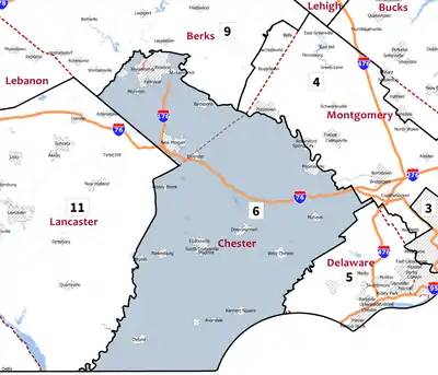
As of January 3, 2021:
| District | Representative | Party |
|---|---|---|
| 5 | Mary Gay Scanlon | Democratic |
| 6 | Chrissy Houlahan | Democratic |
State House of Representatives
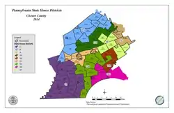
As of January 5, 2021:
State Senate
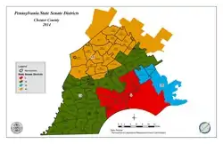
As of January 5, 2021:
| District | Senator | Party |
|---|---|---|
| 9 | John Kane | Democratic |
| 19 | Carolyn Comitta | Democratic |
| 26 | Tim Kearney | Democratic |
| 44 | Katie Muth | Democratic |
Education
Colleges and universities
- Cheyney University of Pennsylvania (partially in Delaware County)
- Delaware County Community College (locations in Exton, Downingtown, Phoenixville and West Grove)
- Immaculata University
- Lincoln University
- Penn State Great Valley
- University of Valley Forge
- West Chester University of Pennsylvania
Public school districts
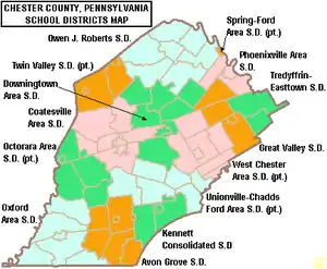
- Avon Grove School District
- Coatesville Area School District
- Downingtown Area School District
- Great Valley School District
- Kennett Consolidated School District
- Octorara Area School District
- Owen J. Roberts School District
- Oxford Area School District
- Phoenixville Area School District
- Spring-Ford Area School District
- Tredyffrin-Easttown School District
- Twin Valley School District
- Unionville-Chadds Ford School District
- West Chester Area School District
Charter schools
- Achievement House Charter School grades 9-12, Exton
- Avon Grove Charter School grades K-12, West Grove
- Chester County Family Academy Charter School grades K-2, West Chester
- Collegium Charter School grades K-12, Exton
- Pennsylvania Leadership Charter School K-12, West Chester
- Renaissance Academy Charter School grades K-12, Phoenixville
- Sankofa Academy Charter School grades 5–8, West Chester
- 21st Century Cyber Charter School grades 6-12. Downingtown.
There are 11 public cyber charter schools and 144 bricks and mortar charter schools in Pennsylvania that are available for free statewide, to children K-12. See: Education in Pennsylvania.[25]
Independent schools
- Bishop Shanahan High School (Archdiocese of Philadelphia)
- Center for Arts and Technology (Administered by Chester County Intermediate Unit)[26]
- Church Farm School (now called CFS the School at Church Farm)
- Delaware Valley Friends School[27]
- Devon Preparatory School
- Fairville Friends School[28] (Chadds Ford, Pennsylvania)
- Goshen Friends School[29] (West Chester, Pennsylvania)
- Kimberton Waldorf School[30] (Kimberton, Pennsylvania)
- London Grove Friends Kindergarten (Kennett Square, Pennsylvania)
- Malvern Preparatory School
- The Concept School - 6th through 12th Grade[31]
- Upattinas School and Resource Center (Glenmoore, Pennsylvania)
- Upland Country Day School (UCDS) - Pre-K through 9th Grade[32]
- Villa Maria Academy (Malvern, Pennsylvania)
- Villa Maria Academy Lower School (Immaculata, Pennsylvania)
- West-Mont Christian Academy[33]
- West Chester Friends School[34]
- West Fallowfield Christian School
- Westtown School
- Windsor Christian Academy - K through 6th Grade[35]
- Windsor Christian Preschool[36]
- Regina Luminis Academy[37]
Libraries
The Chester County Library System in southeastern Pennsylvania was organized in 1965. It is a federated system composed of a District Center Library in Exton and sixteen member libraries. The system provides materials and information for life, work and pleasure.
Communities

Under Pennsylvania law, there are four types of incorporated municipalities: cities, boroughs, townships, and, in at most two cases, towns. The post office uses community names and boundaries that usually do not correspond to the townships, and usually only have the same names as the municipalities for the cities and boroughs. The names used by the post office are generally used by residents to describe where they live. The following cities, boroughs and townships are located in Chester County:
City
Boroughs
Townships
- Birmingham
- Caln
- Charlestown
- East Bradford
- East Brandywine
- East Caln
- East Coventry
- East Fallowfield
- East Goshen
- East Marlborough
- East Nantmeal
- East Nottingham
- East Pikeland
- East Vincent
- East Whiteland
- Easttown
- Elk
- Franklin
- Highland
- Honey Brook
- Kennett
- London Britain
- London Grove
- Londonderry
- Lower Oxford
- New Garden
- New London
- Newlin
- North Coventry
- Penn
- Pennsbury
- Pocopson
- Sadsbury
- Schuylkill
- South Coventry
- Thornbury
- Tredyffrin
- Upper Oxford
- Upper Uwchlan
- Uwchlan
- Valley
- Wallace
- Warwick
- West Bradford
- West Brandywine
- West Caln
- West Fallowfield
- West Goshen
- West Marlborough
- West Nantmeal
- West Nottingham
- West Pikeland
- West Sadsbury
- West Vincent
- West Whiteland
- Westtown
- Willistown
Unincorporated communities
- Birchrunville
- Brandamore
- Bucktown
- Cedar Knoll
- Chester Springs
- Compass
- Coventry
- Coventryville
- Daylesford
- Devault
- Doe Run
- Dowlin Forge
- Embreeville
- Fisherville
- Frazer
- Glenmoore
- Hayti
- Hephzibah
- Humphreyville
- Ironsides
- Jennersville
- Kimberton
- Knauertown
- Landenberg
- Lenape
- Longwood
- Ludwigs Corner
- Lyndell
- Marchwood
- Marshallton
- Mortonville
- Nantmeal Village
- Newlinville
- Parker Ford
- Phillipsville
- Pine Swamp
- Pocopson
- Pomeroy Heights
- Pughtown
- Romansville
- Sadsburyville
- Schades Corner
- Strafford
- Suplee
- Unionville
- Warwick
- Weatherstone
- Wilsons Corner
- Valley Forge
Census-designated places
Census-designated places are geographical areas designated by the U.S. Census Bureau for the purposes of compiling demographic data. They are not actual jurisdictions under Pennsylvania law.
Historic community
Population ranking
The population ranking of the following table is based on the 2010 census of Chester County.[38]
† county seat
| Rank | City/Town/etc. | Municipal type | Population (2010 Census) |
|---|---|---|---|
| 1 | † West Chester | Borough | 18,461 |
| 2 | Phoenixville | Borough | 16,440 |
| 3 | Coatesville | City | 13,100 |
| 4 | Downingtown | Borough | 7,891 |
| 5 | Lionville | CDP | 6,189 |
| 6 | Kennett Square | Borough | 6,072 |
| 7 | Paoli | CDP | 5,575 |
| 8 | Oxford | Borough | 5,077 |
| 9 | Exton | CDP | 4,842 |
| 10 | Chesterbrook | CDP | 4,589 |
| 11 | Berwyn | CDP | 3,631 |
| 12 | Parkesburg | Borough | 3,593 |
| 13 | Thorndale | CDP | 3,407 |
| 14 | Spring City | Borough | 3,323 |
| 15 | Malvern | Borough | 2,998 |
| 16 | West Grove | Borough | 2,854 |
| 17 | South Pottstown | CDP | 2,081 |
| 18 | Kenilworth | CDP | 1,907 |
| 19 | Lincoln University | CDP | 1,726 |
| 20 | Honey Brook | Borough | 1,713 |
| 21 | Eagleview | CDP | 1,644 |
| 22 | Caln | CDP | 1,519 |
| 23 | Devon | CDP | 1,515 |
| 24 | Toughkenamon | CDP | 1,492 |
| 25 | Atglen | Borough | 1,406 |
| 26 | South Coatesville | Borough | 1,303 |
| 27 | Avondale | Borough | 1,265 |
| 28 | Elverson | Borough | 1,225 |
| 29 | Cheyney University (partially in Delaware County) | CDP | 988 |
| 30 | Westwood | CDP | 950 |
| 31 | Cochranville | CDP | 668 |
| 32 | Modena | Borough | 535 |
| 33 | Pomeroy | CDP | 401 |
Climate
Chester County has four distinct seasons and has a hot-summer humid continental climate (Dfa) except for some far southern lowlands which have a humid subtropical climate (Cfa). The hardiness zones are 6b and 7a.
| Climate data for Honey Brook Twp (Elevation: 728 ft (222 m)) 1981-2010 Averages | |||||||||||||
|---|---|---|---|---|---|---|---|---|---|---|---|---|---|
| Month | Jan | Feb | Mar | Apr | May | Jun | Jul | Aug | Sep | Oct | Nov | Dec | Year |
| Average high °F (°C) | 37.6 (3.1) |
40.4 (4.7) |
49.5 (9.7) |
60.1 (15.6) |
70.8 (21.6) |
78.9 (26.1) |
82.9 (28.3) |
82.3 (27.9) |
75.3 (24.1) |
64.1 (17.8) |
52.3 (11.3) |
41.4 (5.2) |
61.4 (16.3) |
| Daily mean °F (°C) | 29.1 (−1.6) |
31.3 (−0.4) |
39.2 (4.0) |
49.3 (9.6) |
59.6 (15.3) |
68.1 (20.1) |
72.6 (22.6) |
71.8 (22.1) |
64.7 (18.2) |
53.6 (12.0) |
43.8 (6.6) |
33.9 (1.1) |
51.5 (10.8) |
| Average low °F (°C) | 20.7 (−6.3) |
22.3 (−5.4) |
28.9 (−1.7) |
38.4 (3.6) |
48.4 (9.1) |
57.3 (14.1) |
62.3 (16.8) |
61.3 (16.3) |
54.2 (12.3) |
43.1 (6.2) |
35.2 (1.8) |
26.4 (−3.1) |
41.6 (5.3) |
| Average precipitation inches (mm) | 3.13 (80) |
2.73 (69) |
3.78 (96) |
3.79 (96) |
4.08 (104) |
4.11 (104) |
4.92 (125) |
3.64 (92) |
4.37 (111) |
4.19 (106) |
3.73 (95) |
3.66 (93) |
46.13 (1,172) |
| Average relative humidity (%) | 69.9 | 67.8 | 62.1 | 62.2 | 64.5 | 72.7 | 72.6 | 73.6 | 74.7 | 72.6 | 72.4 | 72.8 | 69.8 |
| Average dew point °F (°C) | 20.5 (−6.4) |
21.9 (−5.6) |
27.3 (−2.6) |
36.9 (2.7) |
47.6 (8.7) |
59.0 (15.0) |
63.3 (17.4) |
62.9 (17.2) |
56.5 (13.6) |
45.0 (7.2) |
35.5 (1.9) |
26.1 (−3.3) |
42.0 (5.6) |
| Source: PRISM[39] | |||||||||||||
| Climate data for Coatesville, Pennsylvania | |||||||||||||
|---|---|---|---|---|---|---|---|---|---|---|---|---|---|
| Month | Jan | Feb | Mar | Apr | May | Jun | Jul | Aug | Sep | Oct | Nov | Dec | Year |
| Average high °C (°F) | 3.7 (38.7) |
4 (40) |
10.2 (50.4) |
16.8 (62.2) |
22.7 (72.9) |
27.4 (81.3) |
29.9 (85.8) |
28.7 (83.7) |
25.4 (77.7) |
19.1 (66.3) |
11.9 (53.4) |
5.3 (41.6) |
17.1 (62.8) |
| Average low °C (°F) | −6.2 (20.8) |
−6.2 (20.9) |
−1.4 (29.4) |
3.8 (38.8) |
9.5 (49.1) |
14.6 (58.3) |
17.3 (63.2) |
16.3 (61.3) |
12.4 (54.3) |
5.7 (42.3) |
0.4 (32.8) |
−4.6 (23.8) |
5.1 (41.2) |
| Average precipitation mm (inches) | 91 (3.6) |
84 (3.3) |
97 (3.8) |
94 (3.7) |
99 (3.9) |
110 (4.5) |
110 (4.4) |
110 (4.5) |
94 (3.7) |
84 (3.3) |
84 (3.3) |
97 (3.8) |
1,160 (45.8) |
| Source: Weatherbase[40] | |||||||||||||
| Climate data for London Britain (Elevation: 167 ft (51 m)) 1981-2010 Averages | |||||||||||||
|---|---|---|---|---|---|---|---|---|---|---|---|---|---|
| Month | Jan | Feb | Mar | Apr | May | Jun | Jul | Aug | Sep | Oct | Nov | Dec | Year |
| Average high °F (°C) | 40.4 (4.7) |
43.4 (6.3) |
52.2 (11.2) |
64.1 (17.8) |
73.6 (23.1) |
82.5 (28.1) |
86.7 (30.4) |
85.0 (29.4) |
77.9 (25.5) |
66.6 (19.2) |
55.5 (13.1) |
44.3 (6.8) |
64.4 (18.0) |
| Daily mean °F (°C) | 31.9 (−0.1) |
34.5 (1.4) |
42.2 (5.7) |
52.8 (11.6) |
62.4 (16.9) |
71.7 (22.1) |
76.1 (24.5) |
74.6 (23.7) |
67.3 (19.6) |
55.8 (13.2) |
46.0 (7.8) |
36.1 (2.3) |
54.4 (12.4) |
| Average low °F (°C) | 23.5 (−4.7) |
25.6 (−3.6) |
32.2 (0.1) |
41.5 (5.3) |
51.3 (10.7) |
61.0 (16.1) |
65.6 (18.7) |
64.2 (17.9) |
56.8 (13.8) |
44.9 (7.2) |
36.4 (2.4) |
27.9 (−2.3) |
44.3 (6.8) |
| Average precipitation inches (mm) | 3.30 (84) |
2.79 (71) |
4.21 (107) |
3.72 (94) |
4.18 (106) |
4.05 (103) |
4.66 (118) |
3.66 (93) |
4.48 (114) |
3.49 (89) |
3.50 (89) |
3.73 (95) |
45.77 (1,163) |
| Average relative humidity (%) | 66.8 | 63.3 | 59.0 | 58.6 | 62.7 | 66.6 | 68.1 | 69.6 | 71.1 | 69.3 | 67.9 | 68.1 | 65.9 |
| Average dew point °F (°C) | 22.1 (−5.5) |
23.3 (−4.8) |
28.9 (−1.7) |
38.7 (3.7) |
49.5 (9.7) |
60.0 (15.6) |
64.8 (18.2) |
64.0 (17.8) |
57.6 (14.2) |
45.9 (7.7) |
36.0 (2.2) |
26.6 (−3.0) |
43.2 (6.2) |
| Source: PRISM[39] | |||||||||||||
Public health
Opioid crisis
In both 2018 and 2019, deaths from drug overdoses in Chester County declined. Of the 104 drug overdoses recorded by the coroner, an estimated 77 percent involved the presence of fentanyl. One of the reasons for the decline in overdose deaths was "the saturation across the county of Narcan, the anti-opioid nasal spray that can revive someone suffering an overdose." In 2019, any resident of Chester County could obtain a free Narcan dose at community training events across the county.[41]
Notable people
- Jesse B. Aikin (1808-1900), first to produce a song book with a seven-shape note system
- Samuel Barber (1910-1981), one of the most celebrated composers of the 20th century
- Mifflin E. Bell (1847-1904), architect who served from 1883 to 1886 as Supervising Architect of the US Treasury Department
- Scott Brunner (born 1957), NFL quarterback during the 1980s
- Anthony Wayne (1745-1796), American Revolutionary War General known as "Mad" Anthony Wayne
- Samuel Van Leer (1747-1825), Captain during the American Revolution and well known Iron business owner. Owned Warwick Furnace Farms and other nearby historical places.
- Robert Grace (1709–1766) was the first manufacturer of the Franklin stove.
- Isaac Israel Hayes (1832-1881), Arctic explorer and physician
- Mifflin Kenedy (1818-1895), South Texas rancher and steamboat operator; partner in King Ranch, born in Chester County
- Rebecca Webb Lukens (1794-1854) first female owner and manager of the company that became the Lukens Steel Mill
- Franklin MacVeagh (1837-1934), banker and Secretary of the US Treasury
- Bam Margera (born 1979), professional skateboarder, television and radio personality, and daredevil
- Ryan Dunn (1977-2011), actor, television personality, and daredevil. Died in a car crash in West Goshen, Pennsylvania.
- Jon Matlack (born 1950), baseball pitcher for the New York Mets and Texas Rangers (1971–83), All Star and N.L. Champion
- Charles Follen McKim (1847-1909), one of the most prominent American Beaux-Arts architects of the late nineteenth century
- Herb Pennock (1894–1948), Hall of Fame baseball pitcher also known as the Squire of Kennett Square.
- Thomas Buchanan Read (1822-1872), poet and portrait painter
- Bayard Rustin (1912-1987), American civil rights leader posthumously awarded the Presidential Medal of Freedom.
- John Wallace Scott (1832-1903), Medal of Honor recipient during the American Civil War
- M. Night Shyamalan (born 1970), film director
- William Thomas Smedley (1858-1920), artist; member of the National Academy of Design
- James Smith (1719-1806), signer to the United States Declaration of Independence
- Richard Troxell, international opera star, aka America's Tenor. Resides in Chester County.
- George Alexis Weymouth (born 1936), artist (painter); "whip" stager; founder of The Brandywine Conservancy and The Brandywine River Museum
- Thomas Wharton Jr. (1735-1778), served as the first President of Pennsylvania (an office akin to Governor) following the Declaration of Independence from Great Britain
- William (Amos) Wilson (1762-1821), famous folklore figure known as "The Pennsylvania Hermit"
- Andrew Wyeth (1917–2009), artist, son of N.C. Wyeth
- Jamie Wyeth (born 1946), artist, son of Andrew Wyeth
- N.C. Wyeth (1882-1945), artist
- Bernardhus Van Leer (1687–1790), Notable Doctor with rare at home practice and one of first doctors in New York
- Matt Ryan (born 1985), American Football quarterback for the Atlanta Falcons, born in Exton.
- Kyle Gallner (Born 1986) Actor
- Kerr Smith (Born 1972) Actor
- Smedley Butler (1881–1940) Twice recipient of the Medal of Honor, thwarted the Business Plot, advocate for veterans, author.
- Bartholomew Fussell (1794-1871) Abolitionist active in the Underground Railroad, Early advocate for women's careers in medicine.
- Bruce Davidson (born 1949), multiple Olympian in equestrian eventing. Noted competition-horse breeder and trainer. Resides in Chester County.
- Phillip Dutton (Born 1963) Australian-born Olympic-level equestrian rider in eventing, resides in Chester county.
- Boyd Martin Born 1979) Australian-born American equestrian competing in eventing, has participated at two Summer Olympics and resides in Chester county.
- Andrew McKeough (Born 1996) Cappie award-winning actor (Turn: Washington's Spies) photojournalist, raised and resides in Chester County.
References
- "PHMC Historical Markers Search" (Searchable database). Pennsylvania Historical and Museum Commission. Commonwealth of Pennsylvania. Retrieved January 25, 2014.
- "QuickFacts Chester County, Pennsylvania". United States Census Bureau. Retrieved June 18, 2018.
- "Find a County". National Association of Counties. Archived from the original on May 3, 2015. Retrieved June 7, 2011.
- Commonwealth of Pennsylvania (1852–1935). Pennsylvania Archives. 9 Series, 109 Volumes. Philadelphia, Pennsylvania and Harrisburg, Pennsylvania. pp. Series 2, Volume 5: 739–744.
- Futhey, John and Cope, Gilbert (1881). History of Chester County, Pennsylvania, with genealogical and biographical sketches. Philadelphia: L. H. Everts.
- Armstrong, Edward; Editor (1860). Record of the Court at Upland, in Pennsylvania, 1676 to 1681. Memoirs of the Historical Society of Pennsylvania Volume 7. p. 196.
- Swindler, William F., Editor (1973–1979). Sources and Documents of United States Constitutions. 10 Volumes. Dobbs Ferry, New York: Oceana Publications. pp. Vol. 8: 243.
- Ashmead, Henry Gordon (1884). A History of Delaware County, Pennsylvania. Philadelphia: L.H. Everts & Co. pp. 77–83. Retrieved May 24, 2017.
- "2010 Census Gazetteer Files". United States Census Bureau. August 22, 2012. Retrieved March 6, 2015.
- Elevations in Pennsylvania, Commonwealth of Pennsylvania Dept. of Environmental Resources, Bureau of Topographic and Geologic Survey, Information Circular 4, Fourth Series
- Hurdle, Jon (March 8, 2016). "Chester County landfill gas used as alternative to fracking". StateImpact Pennsylvania. Retrieved February 26, 2020.
- "U.S. Decennial Census". United States Census Bureau. Retrieved March 6, 2015.
- "Historical Census Browser". University of Virginia Library. Retrieved March 6, 2015.
- Forstall, Richard L., ed. (March 24, 1995). "Population of Counties by Decennial Census: 1900 to 1990". United States Census Bureau. Retrieved March 6, 2015.
- "Census 2000 PHC-T-4. Ranking Tables for Counties: 1990 and 2000" (PDF). United States Census Bureau. April 2, 2001. Retrieved March 6, 2015.
- "U.S. Census website". United States Census Bureau. Retrieved January 31, 2008.
- Commonwealth of Pennsylvania Department of State. "Information as of 09/14/2020".
- Leip, David. "Dave Leip's Atlas of U.S. Presidential Elections". uselectionatlas.org.
- "Pennsylvania Attorney General Results: Josh Shapiro Wins". The New York Times. Retrieved January 14, 2017.
- "Election results 2017: Democrats take the lead - Chester County Press". www.chestercounty.com.
- Rellahan, Michael (November 6, 2019). "Commissioners race won by Chesco Democrats". Daily Local News. Retrieved November 6, 2019.
- Leip, David. "Dave Leip's Atlas of U.S. Presidential Elections". uselectionatlas.org.
- The leading "other" candidate, Progressive Theodore Roosevelt, received 6,596 votes, while Socialist candidate Eugene Debs received 314 votes, Prohibition candidate Eugene Chafin received 263 votes, and Socialist Labor candidate Arthur Reimer received 4 votes.
- Rellahan, Michael (November 6, 2019). "Historic wins for Ryan, Maddox". Daily Local News. Retrieved November 6, 2019.
- Pennsylvania Department of Education. "Charter Schools in Pennsylvania". Retrieved February 9, 2011.
- "Chester County Intermediate Unit / Overview". www.cciu.org.
- "Private School for Children with LD & Dyslexia in Philadelphia - DVFS". www.dvfs.org.
- "Fairville Friends School - Home". www.fairvillefriends.org/.
- "Goshen Friends School - Home". www.goshenfriends.org.
- "Kimberton Waldorf School - The Art of Education". kimberton.org.
- "Welcome to TCS! - The Concept School". www.theconceptschool.org.
- "Upland Country Day School Best Private Schools in Chester County". www.uplandcds.org.
- "West-Mont Christian Academy". www.west-mont.org.
- "westchesterfriends". westchesterfriends.
- "Windsor Christian Academy – Classical Christian Education in Upper Uwchlan, PA". www.windsorca.org.
- "Windsor Christian Preschool - Offering Morning or Afternoon Preschool Classes for 2-1/2, 3, 4, or 5 Year Olds". www.windsorcp.org.
- "Regina Luminis Academy - Catholic Classical Education". Regina Luminis Academy - Catholic Classical Education.
- "2010 U.S. Census website". United States Census Bureau. Retrieved February 10, 2013.
- "PRISM Climate Group, Oregon State University". Retrieved August 9, 2019.
- "Weatherbase.com". Weatherbase. 2013. Retrieved on 2 September 2019.
- Rellahan, Michael P. (February 20, 2020). "Overdoses in Chester County decrease for second year in a row". Daily Local News. Retrieved February 20, 2020.
External links
| Wikimedia Commons has media related to Chester County, Pennsylvania. |
| Wikivoyage has a travel guide for Chester County, Pennsylvania. |
- Chester County Home Page
- Chester County Government Meeting Minutes and local news at TownWatcher
- Chester County Press Newspapers & Magazines
- Collection of Chester County Quaker property records and other manuscripts from Friends Historical Library of Swarthmore College
Places adjacent to Chester County, Pennsylvania | ||||||||||
|---|---|---|---|---|---|---|---|---|---|---|
| ||||||||||
| Counties |  | |
|---|---|---|
| Major cities | ||
| Cities and towns 50k-99k | ||
| Cities and towns 30k-50k | ||

| Authority control |
|---|