Delaware County, Pennsylvania
Delaware County, colloquially referred to as Delco,[2] is a county located in the U.S. state of Pennsylvania that borders Philadelphia. With a population of 566,747,[3] it is the fifth most populous county in Pennsylvania, and the third smallest in area. The county was created on September 26, 1789, from part of Chester County, and named for the Delaware River.
Delaware County | |
|---|---|
| County of Delaware, Pennsylvania | |
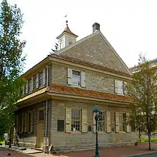
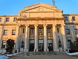 Delaware County Courthouse in Media, viewed from south | |
 Flag  Seal | |
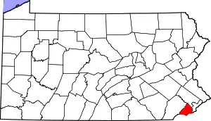 Location within the U.S. state of Pennsylvania | |
 Pennsylvania's location within the U.S. | |
| Coordinates: 39°55′N 75°24′W | |
| Country | |
| State | |
| Founded | September 26, 1789 |
| Named for | Delaware River |
| Seat | Media |
| Largest city | Chester |
| Area | |
| • Total | 191 sq mi (490 km2) |
| • Land | 184 sq mi (480 km2) |
| • Water | 6.8 sq mi (18 km2) 3.5%% |
| Population | |
| • Estimate (2019) | 566,747 |
| • Density | 3,065/sq mi (1,183/km2) |
| Congressional district | 5th |
| Website | www |
| Designated | October 3, 1982[1] |
Its county seat is Media.[4] Until 1850, Chester was the county seat of Delaware County and, before that, of Chester County.
Delaware County is adjacent to the city-county of Philadelphia and is included in the Philadelphia–Camden–Wilmington, PA–NJ–DE–MD Metropolitan Statistical Area. Delaware County is the only county covered in its entirety by area codes 610 and 484.
History
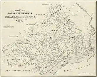
Delaware County lies in the river and bay drainage area named "Delaware" in honor of Thomas West, 3rd Baron De La Warr, Governor of the nearby English colony of Virginia. The land was explored by Henry Hudson in 1609, and over the next several decades it was variously claimed and settled by the Swedes, the Dutch, and the English. Its original human inhabitants were the Lenni-Lenape tribe of American Indians.
Once the Dutch were defeated and the extent of New York was determined, King Charles II of England made his grant to William Penn in order to found the colony which came to be named Pennsylvania. Penn divided his colony into three counties: Bucks, Philadelphia, and Chester. The riverfront land south of Philadelphia, being the most accessible, was quickly granted and settled. In 1789, the southeastern portion of Chester County was divided from the rest and named Delaware County for the Delaware River.
Geography
According to the U.S. Census Bureau, the county has a total area of 191 square miles (490 km2), of which 184 square miles (480 km2) is land and 6.8 square miles (18 km2) (3.5%) is water.[5] It is the third-smallest county in Pennsylvania by area.
Delaware County is roughly diamond- or kite-shaped, with the four sides formed by the Chester County boundary to the northwest, the boundary with the state of Delaware (a portion of the "Twelve Mile Circle") to the southwest, the Delaware River (forming the border with the state of New Jersey) to the southeast, and the city of Philadelphia and Montgomery County to the east and northeast.
The lowest point in the state of Pennsylvania is located on the Delaware River in Marcus Hook in Delaware County, where it flows out of Pennsylvania and into Delaware. The highest point in Delaware County is 500 feet at two points southeast of Wyola in Newtown Township .
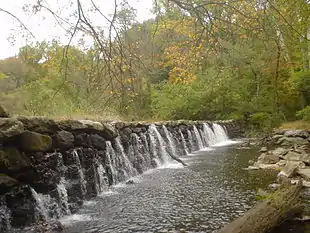
Waterways in Delaware County generally flow in a southward direction and ultimately drain into the Delaware River. The waterways are, from west to east: the Brandywine River (forming a portion of the county's western boundary with Chester County), Naaman's Creek, Stoney Creek, Chester Creek, Ridley Creek, Crum Creek, Muckinipates Creek, Darby Creek and Cobbs Creek (forming a portion of the county's eastern boundary with Philadelphia). Crum Creek was dammed in 1931 near Pennsylvania Route 252 to fill Springton Lake (also known as Geist Reservoir), an approximately 391-acre (1.58 km2)[6] drinking water reservoir maintained by Aqua America, the county's largest lake.
The Trainer Refinery and the Port of Chester are located along the shores of the Delaware River.
Adjacent counties
- Montgomery County, Pennsylvania (north)
- Philadelphia County, Pennsylvania (northeast)
- Gloucester County, New Jersey (southeast)
- New Castle County, Delaware (southwest)
- Chester County, Pennsylvania (west)
Delaware County is one of four counties in the United States to border a state with which it shares the same name (the other three are Nevada County, California, Texas County, Oklahoma, and Ohio County, West Virginia).
National protected areas
State protected area
2,600 acres (11 km2) of the county are occupied by the Ridley Creek State Park.
Demographics
| Historical population | |||
|---|---|---|---|
| Census | Pop. | %± | |
| 1790 | 9,469 | — | |
| 1800 | 12,809 | 35.3% | |
| 1810 | 14,734 | 15.0% | |
| 1820 | 14,810 | 0.5% | |
| 1830 | 17,323 | 17.0% | |
| 1840 | 19,791 | 14.2% | |
| 1850 | 24,679 | 24.7% | |
| 1860 | 30,597 | 24.0% | |
| 1870 | 39,403 | 28.8% | |
| 1880 | 56,101 | 42.4% | |
| 1890 | 74,683 | 33.1% | |
| 1900 | 94,762 | 26.9% | |
| 1910 | 117,906 | 24.4% | |
| 1920 | 173,084 | 46.8% | |
| 1930 | 280,264 | 61.9% | |
| 1940 | 310,756 | 10.9% | |
| 1950 | 414,234 | 33.3% | |
| 1960 | 553,154 | 33.5% | |
| 1970 | 600,035 | 8.5% | |
| 1980 | 555,007 | −7.5% | |
| 1990 | 547,651 | −1.3% | |
| 2000 | 550,864 | 0.6% | |
| 2010 | 558,979 | 1.5% | |
| 2019 (est.) | 566,747 | [7] | 1.4% |
| U.S. Decennial Census[8] 1790–1960[9] 1900–1990[10] 1990–2000[11] 2010–2019[3] | |||
As of the 2010 census, the county was 71.1% White non-Hispanic, 19.7% Black or African American, 0.2% Native American or Alaskan Native, 4.7% Asian, <0.1% Native Hawaiian, 2.0% were two or more races, and 0.9% were some other race. 3.0% of the population were of Hispanic or Latino ancestry.
As of the 2000 census, there were 550,864 people, 206,320 households, and 139,472 families residing in the county. The population density was 2,990 people per square mile (1,155/km2). There were 216,978 housing units at an average density of 1,178 per square mile (455/km2). The racial makeup of the county was 80.3% White, 14.5% African American, 0.1% Native American, 3.3% Asian, <0.1% Pacific Islander, 0.6% from other races, and 1.2% from two or more races. 1.5% of the population were Hispanic or Latino of any race. 24.6% were of Irish, 17.5% Italian, 10.1% German and 6.7% English ancestry.
There were 206,320 households, out of which 31.5% had children under the age of 18 living with them, 50.8% were married couples living together, 12.9% had a female householder with no husband present, and 32.4% were non-families. 27.6% of all households were made up of individuals, and 11.6% had someone living alone who was 65 years of age or older. The average household size was 2.56 and the average family size was 3.17.
In the county, the population was spread out, with 24.8% under the age of 18, 8.9% from 18 to 24, 28.8% from 25 to 44, 21.9% from 45 to 64, and 15.6% who were 65 years of age or older. The median age was 37 years. For every 100 females there were 91.2 males. For every 100 females age 18 and over, there were 86.9 males.
The median income for a household in the county was $50,092, and the median income for a family was $61,590. Males had a median income of $44,155 versus $31,831 for females. The per capita income for the county was $25,040. About 5.8% of families and 8.0% of the population were below the poverty line, including 10.0% of those under age 18 and 7.1% of those age 65 or over.
Communities
Under Pennsylvania law, there are four types of incorporated municipalities: cities, boroughs, townships, and exactly one town. There are 49 municipalities in Delaware County:
City
Boroughs
Townships
Census-designated places
Census-designated places are geographical areas designated by the U.S. Census Bureau for the purposes of compiling demographic data. They are not actual jurisdictions under Pennsylvania law. Other unincorporated communities, such as villages, may be listed here as well.
Unincorporated communities
Population ranking
The population ranking of the following table is based on the 2010 census of Delaware County.[12]
† county seat
| Rank | City/Town/etc. | Municipal type | Population (2010 Census) |
|---|---|---|---|
| 1 | Upper Darby | Township | 82,795 |
| 2 | Haverford | Township | 48,491 |
| 3 | Chester | City | 33,972 |
| 4 | Radnor | Township | 31,531 |
| 5 | Drexel Hill | CDP | 28,043 |
| 6 | Springfield | Township | 24,211 |
| 7 | Ardmore (partially in Montgomery County) | CDP | 12,455 |
| 8 | Yeadon | Borough | 11,443 |
| 9 | Broomall | CDP | 10,789 |
| 10 | Darby | Borough | 10,687 |
| 11 | Lansdowne | Borough | 10,620 |
| 12 | Woodlyn | CDP | 9,485 |
| 13 | Collingdale | Borough | 8,786 |
| 14 | Folsom | CDP | 8,323 |
| 15 | Brookhaven | Borough | 8,006 |
| 16 | Village Green-Green Ridge | CDP | 7,822 |
| 17 | Glenolden | Borough | 7,153 |
| 18 | Ridley Park | Borough | 7,002 |
| 19 | Clifton Heights | Borough | 6,652 |
| 20 | Folcroft | Borough | 6,606 |
| 21 | Prospect Park | Borough | 6,454 |
| 22 | Swarthmore | Borough | 6,194 |
| 23 | Norwood | Borough | 5,890 |
| 24 | Sharon Hill | Borough | 5,697 |
| 25 | † Media | Borough | 5,327 |
| 26 | Boothwyn | CDP | 4,933 |
| 27 | Aldan | Borough | 4,152 |
| 28 | Linwood | CDP | 3,281 |
| 29 | Upland | Borough | 3,239 |
| 30 | Lima | CDP | 2,735 |
| 31 | Morton | Borough | 2,669 |
| 32 | East Lansdowne | Borough | 2,668 |
| 33 | Colwyn | Borough | 2,546 |
| 34 | Chester Heights | Borough | 2,531 |
| 35 | Eddystone | Borough | 2,410 |
| 36 | Marcus Hook | Borough | 2,397 |
| 37 | Parkside | Borough | 2,328 |
| 38 | Trainer | Borough | 1,828 |
| 39 | Haverford College (partially in Montgomery County) | CDP | 1,331 |
| 40 | Millbourne | Borough | 1,159 |
| 41 | Cheyney University (mostly in Chester County) | CDP | 988 |
| 42 | Rose Valley | Borough | 913 |
| 43 | Rutledge | Borough | 784 |
Politics and government
| Year | Republican | Democratic | Third parties |
|---|---|---|---|
| 2020 | 36.0% 118,639 | 62.8% 206,709 | 1.2% 4,056 |
| 2016 | 37.0% 110,667 | 59.3% 177,402 | 3.8% 11,267 |
| 2012 | 38.8% 110,853 | 60.2% 171,792 | 1.0% 2,919 |
| 2008 | 38.8% 115,273 | 60.1% 178,870 | 1.1% 3,367 |
| 2004 | 42.3% 120,425 | 57.2% 162,601 | 0.5% 1,512 |
| 2000 | 42.7% 105,836 | 54.4% 134,861 | 3.0% 7,380 |
| 1996 | 39.5% 92,628 | 49.4% 115,946 | 11.2% 26,174 |
| 1992 | 40.8% 108,587 | 41.8% 111,210 | 17.4% 46,277 |
| 1988 | 60.0% 147,656 | 39.0% 96,144 | 1.0% 2,505 |
| 1984 | 61.8% 161,754 | 37.5% 98,207 | 0.7% 1,821 |
| 1980 | 55.8% 143,282 | 34.4% 88,314 | 9.8% 25,263 |
| 1976 | 54.9% 148,679 | 43.3% 117,252 | 1.8% 4,963 |
| 1972 | 63.9% 175,414 | 34.3% 94,144 | 1.8% 4,893 |
| 1968 | 50.2% 133,777 | 40.1% 106,695 | 9.7% 25,964 |
| 1964 | 42.9% 111,189 | 56.8% 147,189 | 0.3% 717 |
| 1960 | 52.0% 135,672 | 47.8% 124,629 | 0.2% 482 |
| 1956 | 63.5% 143,663 | 36.3% 82,024 | 0.2% 523 |
| 1952 | 61.6% 129,743 | 38.1% 80,316 | 0.3% 689 |
| 1948 | 60.9% 93,412 | 37.3% 57,156 | 1.8% 2,747 |
| 1944 | 54.8% 78,533 | 44.7% 64,021 | 0.5% 755 |
| 1940 | 56.9% 80,158 | 42.7% 60,225 | 0.4% 549 |
| 1936 | 52.4% 74,899 | 45.5% 65,117 | 2.1% 2,997 |
| 1932 | 68.2% 75,291 | 29.4% 32,413 | 2.5% 2,705 |
| 1928 | 73.6% 83,092 | 26.0% 29,378 | 0.4% 471 |
| 1924 | 81.8% 41,998 | 12.4% 6,368 | 5.8% 2,979 |
| 1920 | 75.3% 34,126 | 21.2% 9,602 | 3.5% 1,565 |
| 1916 | 66.0% 16,315 | 31.3% 7,742 | 2.7% 677 |
| 1912 | 36.2% 8,418 | 25.8% 6,001 | 38.0% 8,819[lower-alpha 1] |
| 1908 | 70.8% 15,184 | 26.7% 5,727 | 2.6% 550 |
| 1904 | 78.2% 15,032 | 18.6% 3,586 | 3.2% 618 |
| 1900 | 75.0% 13,794 | 23.1% 4,249 | 2.0% 358 |
| 1896 | 75.3% 13,979 | 22.5% 4,169 | 2.3% 424 |
| 1892 | 60.7% 9,272 | 36.2% 5,520 | 3.1% 477 |
| 1888 | 62.0% 8,791 | 35.5% 5,028 | 2.5% 351 |
| 1884 | 61.2% 7,512 | 37.0% 4,538 | 1.7% 211 |
| 1880 | 60.0% 7,008 | 38.8% 4,473 | 0.3% 38 |
The county has operated under a home-rule charter with five at-large council-members since 1972.
In November 2019, there was a historically significant election held that resulted in the Democratic Party taking total control of the county council for the first time since the Civil War.[14] Another notable election result was that of Nusrat Rashid, who now enjoys the accolades of being the first African-American female Common Pleas judge in the county, as well as being the first Muslim to be elected into any judicial position in the entire Commonwealth.[15] Also of note was the election of Jack Stollsteimer to the position of District Attorney, representing the first time a Democrat has ever had this position in the county.[16] This major change has been colloquially referred to as "The Blue Wave."[17]
As of June 2017, there were 391,683 registered voters in Delaware County.[13]
- Democratic: 178,788 (45.65%)
- Republican: 164,106 (41.88%)
- No Affiliation: 25,892 (6.61%)
- Other Parties: 22,897 (5.85%)
Until recent years, Delaware County was regarded as a strongly Republican county. The Delaware County Republican [political machine]] was controlled by William McClure and his son John J. McClure from 1875 to 1965.[18] Delaware County voted for the Republican candidate in nearly every election from 1854 through 1988, one of the few exceptions being Lyndon Johnson's national landslide of 1964. As a measure of how Republican the county was, Franklin Roosevelt was completely shut out in all four of his successful campaigns for president. Even in his 46-state landslide victory of 1936, Roosevelt only got 45 percent of Delaware County's vote.
In 1992, however, the county swung from a 21-point win for George H. W. Bush to a narrow one-point win for Bill Clinton, who became only the second Democrat to win the county in the 20th century. Clinton won it just under 10 points in 1996, coming up just short of a majority. It has gone Democratic in every Presidential election since then by 10 points or more by progressively-increasing margins. In the 2004 election Democratic presidential candidate John Kerry won the county by 14 points. Barack Obama won it by resounding 21-point margins in each of his bids for president. Hillary Clinton carried it by 22 points in 2016. Clinton turned in her second-best performance in the state, behind only Philadelphia, thus cementing Delaware County's status as one of the most Democratic suburban counties in the nation. Underlining this, Joe Biden carried it in 2020 with 62 percent of the vote, his second-strongest performance in Pennsylvania. Donald Trump turned in the worst showing for a Republican in the county in over 160 years.
While the longstanding Republican registration edge has been erased, Republicans still remain competitive with Democrats at the state and local level. Most Republicans from the county tend to be fiscally conservative and socially moderate, as is the case with Republicans from most suburban Philadelphia counties. In the 2004 US Senate election, Republican Arlen Specter defeated Joe Hoeffel but Democrat Bob Casey, Jr. defeated Rick Santorum in the 2006 Senate election. All three Democratic state row office candidates carried it in 2008.
In 2016, Delaware County elected all Democrats in national office elections except Republican Patrick Meehan (U.S. Representative).[19]
All of Delaware County is located in the state's 5th congressional district, represented by Democrat Mary Gay Scanlon. Prior to 2019, most of Delaware County had been in the 7th congressional district. The district had been held for 20 years by Republican Curt Weldon until he was ousted by Joe Sestak, a retired admiral, in the 2006 U.S. House of Representatives election. Also in the 2006 election, Democrat Bryan Lentz unseated Republican incumbent State Representative Tom Gannon in the 161st House district. In 2010 Sestak ran for the senate seat vacated by Arlen Specter and was replaced by Republican Pat Meehan, who defeated Lentz, the Democratic candidate. Lentz was replaced in the State House by Joe Hackett, a Republican. Meehan represented the 7th district until his resignation on April 27, 2018.[20] Before it was thrown out by a Pennsylvania Supreme Court decision in 2018, the 7th Congressional District had been regarded one of the most irregularly drawn districts in the nation.[21]
In the 2019 elections for the Delaware County Council, Republicans John McBlain and Colleen Morrone had served two terms and were not eligible for a third. Michael Culp, the council's third Republican, chose not to run. After a campaign described as having a good share of mud-throwing,[22] Democrats swept the board and elected Monica Taylor, Elaine P. Schaefer, and Christine Reuther. This was the first time in history that the county had an all-Democratic county council.[23]
Delaware County Council[24]
| Office | Holder | Party |
|---|---|---|
| County Councilman (Chair) | Brian P. Zidek | Democratic |
| County Councilwoman (Vice-Chair) | Dr. Monica Taylor | Democratic |
| County Councilman | Kevin M. Madden | Democratic |
| County Councilwoman | Christine Reuther | Democratic |
| County Councilwoman | Elaine Paul Schaefer | Democratic |
County row officers
Row officers, a term unique to Pennsylvania, are a conglomeration of elected officials defined by Article IX, Section 4 of the Pennsylvania Constitution. This unit of officers includes the position of controller, District Attorney, treasurer, sheriff, register of wills, recorder of deeds, prothonotaries, clerks of the court, and the coroner. It is thought that this term originated because these positions were arranged in a row on a typical ballot.[25]
| Office | Holder | Party |
|---|---|---|
| Controller | Joanne Phillips, Esquire | Democratic |
| District Attorney | Jack Stollsteimer | Democratic |
| Register of Wills | Mary J. Walk, Esquire | Democratic |
| Sheriff | Jerry Sanders | Democratic |
United States Senate
| Senator | Party |
|---|---|
| Pat Toomey | Republican |
| Bob Casey | Democratic |
United States House of Representatives
| District | Representative | Party |
|---|---|---|
| 5 | Mary Gay Scanlon | Democratic |
State Senate
| District | Representative | Party |
|---|---|---|
| 8 | Anthony Hardy Williams | Democratic |
| 9 | John I. Kane | Democratic |
| 17 | Amanda Cappelletti | Democratic |
| 26 | Tim Kearney | Democratic |
State House of Representatives
Corrections
The George W. Hill Correctional Facility (Delaware County Prison) is located in Thornbury Township.[26][27] The jail houses pre-trial inmates and convicted persons who are serving sentences of no longer than two years less one day.[27] It is operated by the for-profit prison corporation GEO Group, of Boca Raton, Florida. It is the only privately operated county-level correctional facility in Pennsylvania, although there are plans for it to be deprivatized as early as December 31, 2020.[28][29]
Education
Public school districts
- Chester Upland School District
- Chichester School District
- Delaware County Technical High School, Aston
- Garnet Valley School District
- Haverford Township School District
- Interboro School District
- Marple Newtown School District
- Penn-Delco School District
- Radnor Township School District
- Ridley School District
- Rose Tree Media School District
- Southeast Delco School District
- Springfield School District
- Upper Darby School District
- Wallingford-Swarthmore School District
- William Penn School District
Charter schools
In Pennsylvania, charter schools are public schools. They receive a per pupil funding from the state along with federal funding. They are eligible to apply for many competitive grants offered by the state and federal governments. There are two charter schools in 2011. They are located within the attendance borders of the Chester Upland School District. Charter schools may accept students from neighboring school districts.
- Chester Community Charter School
- Widener Partnership Charter School
- Chester Charter School for the Arts, (K–6) approved by PA Charter Appeal Board July 2012
Private schools
In 1963 the Roman Catholic Archdiocese of Philadelphia had 48 Catholic K-8/elementary schools in Delaware County with a total of 39,695 students, which was the highest ever enrollment. From 1971 to 2012, 20 of these schools closed, with ten of them closing from 2003 to 2012. By 2012 there were 28 Catholic K-8/elementary schools in Delaware County with a total of 8,291 students.[30] One notable private school is Friends School Haverford.
Colleges and universities
- Cabrini College
- Cheyney University
- Eastern University
- Delaware County Community College (locations in Marple Township, Upper Darby and Sharon Hill)
- Haverford College
- Neumann University
- Pendle Hill Quaker Center for Study and Contemplation
- Pennsylvania Institute of Technology
- Penn State Brandywine
- Rosemont College
- Swarthmore College
- Villanova University
- Widener University
- Williamson College of the Trades
Adult education
Libraries
Transportation
Delaware County is bisected north to south by Blue Route Interstate 476, which connects I-76 just north of the extreme northern corner of the county to I-95, which parallels the Delaware River along the southeastern edge of the county.
Delaware County is home to SEPTA's 69th Street Terminal in Upper Darby, and is served by the Norristown High Speed Line (P&W), two Red Arrow trolley lines (Routes 101 and 102), four Regional Rail Lines (the Airport Line, Wilmington/Newark Line, Media/Elwyn Line, and Paoli/Thorndale Line), and a host of bus routes.
The western portion of Philadelphia International Airport is located in Delaware County, and the county hosts some airport-related commerce such as Philadelphia's UPS terminal and airport hotels.
Recreation
Parks
There is one Pennsylvania state park in Delaware County.
County parks include:
- Clayton Park & Golf Course
- Glen Providence Park
- Kent Park/Dog Park
- Rose Tree Park
- Smedley Park
- Upland Park
Racing
Harrah's Philadelphia Casino & Racetrack is a harness racing track and casino (i.e., "racino") located on the Chester, Pennsylvania waterfront. It is owned by Vici Properties and operated by Caesars Entertainment.
Sports
The city of Chester is home to the Philadelphia Union of Major League Soccer. The team plays at Talen Energy Stadium, a venue located at the base of the Commodore Barry Bridge.
Delaware County is the traditional home of women's professional soccer in the Philadelphia area. The former Philadelphia Charge of the defunct Women's United Soccer Association played at Villanova Stadium, which is located on the campus of Villanova University. The Philadelphia Independence of Women's Professional Soccer succeeded the Charge and played at Widener University's Leslie Quick Stadium in 2011.
Delaware County is the home of one of oldest baseball leagues in the country, the Delco League, which at one time was known for featuring future, former, and even current major league players who were offered more money than their current teams would pay them.[34][35][36]
Every summer, Delaware County is home to the Delco Pro-Am, a basketball league consisting of current, future, and former NBA players as well as local standout players.[37]
Delaware County is also the former home of a rugby league team called the Aston Bulls, a member of the American National Rugby League.
Darby was home to the Hilldale Club, the 1925 Colored World Series Champions.
Media
The county itself is serviced by several newspapers, most notably the News of Delaware County, the Delaware County Daily Times, The Suburban and Wayne Times, and The Spirit, the only minority owned newspaper serving Delaware County. The Philadelphia Inquirer also has a significant presence, reflecting Philadelphia's influence on Delaware County and the rest of the metro. Delaware County Magazine is the news magazine with the largest circulation in Delaware County, reaching over 186,000 homes.
Climate
Delaware County has two regions: the Piedmont with a hot-summer humid continental climate (Dfa) and the Atlantic Coastal Plain with a humid subtropical climate (Cfa). The line approximates U.S. Route 1. The hardiness zones are 7a and 7b.
| Climate data for Newtown Square (Elevation: 456 ft (139 m)) 1981–2010 Averages | |||||||||||||
|---|---|---|---|---|---|---|---|---|---|---|---|---|---|
| Month | Jan | Feb | Mar | Apr | May | Jun | Jul | Aug | Sep | Oct | Nov | Dec | Year |
| Average high °F (°C) | 38.6 (3.7) |
41.8 (5.4) |
50.4 (10.2) |
62.3 (16.8) |
72.1 (22.3) |
81.0 (27.2) |
85.3 (29.6) |
83.5 (28.6) |
76.8 (24.9) |
65.5 (18.6) |
54.1 (12.3) |
42.6 (5.9) |
62.9 (17.2) |
| Daily mean °F (°C) | 30.4 (−0.9) |
33.1 (0.6) |
40.6 (4.8) |
51.6 (10.9) |
61.2 (16.2) |
70.5 (21.4) |
75.2 (24.0) |
73.7 (23.2) |
66.3 (19.1) |
55.0 (12.8) |
44.8 (7.1) |
34.6 (1.4) |
53.2 (11.8) |
| Average low °F (°C) | 22.2 (−5.4) |
24.3 (−4.3) |
30.9 (−0.6) |
40.8 (4.9) |
50.2 (10.1) |
60.0 (15.6) |
65.1 (18.4) |
63.8 (17.7) |
55.7 (13.2) |
44.4 (6.9) |
35.5 (1.9) |
26.6 (−3.0) |
43.4 (6.3) |
| Average precipitation inches (mm) | 3.36 (85) |
2.80 (71) |
3.89 (99) |
3.84 (98) |
4.08 (104) |
3.94 (100) |
4.71 (120) |
3.88 (99) |
4.65 (118) |
3.87 (98) |
3.61 (92) |
3.89 (99) |
46.52 (1,182) |
| Average relative humidity (%) | 68.3 | 65.0 | 60.5 | 59.4 | 63.2 | 68.2 | 68.2 | 70.5 | 71.7 | 70.5 | 69.7 | 70.8 | 67.2 |
| Average dew point °F (°C) | 21.2 (−6.0) |
22.6 (−5.2) |
28.0 (−2.2) |
37.9 (3.3) |
48.6 (9.2) |
59.5 (15.3) |
64.0 (17.8) |
63.5 (17.5) |
56.9 (13.8) |
45.6 (7.6) |
35.5 (1.9) |
26.1 (−3.3) |
42.5 (5.8) |
| Source: PRISM[38] | |||||||||||||
| Climate data for Chester (Elevation: 10 ft (3 m)) 1981–2010 Averages | |||||||||||||
|---|---|---|---|---|---|---|---|---|---|---|---|---|---|
| Month | Jan | Feb | Mar | Apr | May | Jun | Jul | Aug | Sep | Oct | Nov | Dec | Year |
| Average high °F (°C) | 40.5 (4.7) |
44.2 (6.8) |
52.0 (11.1) |
63.4 (17.4) |
73.4 (23.0) |
82.7 (28.2) |
87.0 (30.6) |
85.2 (29.6) |
78.3 (25.7) |
66.7 (19.3) |
56.1 (13.4) |
45.0 (7.2) |
64.6 (18.1) |
| Daily mean °F (°C) | 33.7 (0.9) |
36.5 (2.5) |
43.7 (6.5) |
54.3 (12.4) |
64.1 (17.8) |
73.7 (23.2) |
78.3 (25.7) |
76.8 (24.9) |
69.5 (20.8) |
58.1 (14.5) |
48.3 (9.1) |
38.2 (3.4) |
56.4 (13.6) |
| Average low °F (°C) | 26.8 (−2.9) |
28.9 (−1.7) |
35.3 (1.8) |
45.2 (7.3) |
54.8 (12.7) |
64.6 (18.1) |
69.7 (20.9) |
68.4 (20.2) |
60.7 (15.9) |
49.4 (9.7) |
40.5 (4.7) |
31.4 (−0.3) |
48.1 (8.9) |
| Average precipitation inches (mm) | 3.15 (80) |
2.70 (69) |
3.87 (98) |
3.62 (92) |
3.81 (97) |
3.80 (97) |
4.65 (118) |
3.56 (90) |
4.21 (107) |
3.44 (87) |
3.27 (83) |
3.62 (92) |
43.70 (1,110) |
| Average relative humidity (%) | 65.3 | 60.7 | 57.6 | 57.2 | 60.8 | 62.7 | 64.4 | 65.8 | 67.8 | 67.3 | 65.3 | 65.1 | 63.4 |
| Average dew point °F (°C) | 23.3 (−4.8) |
24.2 (−4.3) |
29.7 (−1.3) |
39.5 (4.2) |
50.3 (10.2) |
60.2 (15.7) |
65.3 (18.5) |
64.5 (18.1) |
58.4 (14.7) |
47.3 (8.5) |
37.2 (2.9) |
27.5 (−2.5) |
44.0 (6.7) |
| Source: PRISM[38] | |||||||||||||
Notes
- The leading “other” candidate, Progressive Theodore Roosevelt, received 8,272 votes, while Socialist candidate Eugene Debs received 374 votes, Prohibition candidate Eugene Chafin received 170 votes, and Socialist Labor candidate Arthur Reimer received 3 votes.
References
- "PHMC Historical Markers Search" (Searchable database). Commonwealth of Pennsylvania. Pennsylvania Historical and Museum Commission. Retrieved February 11, 2015.
- "Delco Sheriff: Don't fall for jury duty scam". Delco Times. Retrieved July 1, 2014.; McCrystal, Laura (June 27, 2014). "Voting Wards To Be Changed in Delco's Radnor Township". Philly.com. Retrieved July 1, 2014.; McCrystal, Laura (June 30, 2014). "Roadwork in Delco to affect I-95 and I-476 this week". Philly.com. Retrieved July 1, 2014.; DaGrassa, Peg (June 27, 2014). "Here's the Scoop on Ross, Fresh Stop, KFC and Other Delco Businesses". Delco News Network. Retrieved July 1, 2014.; Kurtz, Paul (June 27, 2014). "Delco Homeless Families Get A Day of Escapist Fun". CBS Philly. Retrieved July 1, 2014.;"Delco's bars, taverns are really heating up". Delco Times. June 16, 2014. Retrieved July 1, 2014.
- "State & County QuickFacts" (PDF). Delaware County. Retrieved February 7, 2017.
- "Find a County". National Association of Counties. Archived from the original on May 31, 2011. Retrieved June 7, 2011.
- "2010 Census Gazetteer Files". United States Census Bureau. August 22, 2012. Retrieved March 6, 2015.
- "Crum". Chester – Ridley – Crum Watersheds Association. Archived from the original on October 16, 2008.
- "Population and Housing Unit Estimates". Retrieved March 26, 2020.
- "U.S. Decennial Census". United States Census Bureau. Retrieved May 31, 2017.
- "Historical Census Browser". University of Virginia Library. Retrieved May 31, 2017.
- "Population of Counties by Decennial Census: 1900 to 1990". United States Census Bureau. Retrieved May 31, 2017.
- "Census 2000 PHC-T-4. Ranking Tables for Counties: 1990 and 2000" (PDF). United States Census Bureau. Retrieved May 31, 2017.
- "2010 Census". United States Census. Archived from the original on December 6, 2013. Retrieved February 10, 2013.
- Leip, David. "Dave Leip's Atlas of U.S. Presidential Elections". uselectionatlas.org. Retrieved November 25, 2018.
- "Democrats take control in Delaware County for first time since Civil War". Associated Press. November 6, 2019. Retrieved March 2, 2020.
- Rose, Alex. "Rashid makes history as four new Delco judges take oath". The Delaware County Daily Times. Retrieved March 2, 2020.
- "Election Day 2019: Democrats Sweep Delaware County Council For First Time Since Civil War". November 6, 2019. Retrieved March 2, 2020.
- Terruso, Julia. "The blue wave crashed down on Pennsylvania again, as voters from Philly to Delaware County turned left". inquirer.com. Retrieved March 2, 2020.
- McLarnon, John Morrison (2003). Ruling Suburbia: John J. McClure and the Republican Machine in Delaware County. Newark, Delaware: University of Delaware Press. p. 11. ISBN 0-87413-814-0. Retrieved June 28, 2018.
- "Pennsylvania Elections - County Results". electionreturns.pa.gov. Retrieved November 25, 2016.
- Tamari, Jonathan (April 27, 2018). "Rep. Pat Meehan resigns; will pay back $39,000 used for harassment settlement". Philadelphia Inquirer. Retrieved April 27, 2018.
- Ingraham, Christopher. "This is the best explanation of gerrymandering you will ever see". Washington Post. Retrieved March 2, 2015.
- Twitter, Kathleen E. Carey kcarey@21st-centurymedia com @dtbusiness on. "Historic vote, balance of power in Delco at stake in Tuesday's election". The Delaware County Daily Times. Retrieved November 23, 2019.
- "Democrats Sweep Delaware County Council Race In Historic Election". Media, PA Patch. November 5, 2019. Retrieved November 23, 2019.
- "Elected Officials - Delaware County, Pennsylvania". co.delaware.pa.us.
- Sentinel, Daniel Walmer, The. "Row officers: What is their role in county government?". The Sentinel. Retrieved March 2, 2020.
- "Chapter 7 7–11 Archived March 20, 2012, at the Wayback Machine." Comprehensive Zoning Plan. Thornbury Township. Retrieved on September 6, 2011. "The three major institutions found in the Township, the Delaware County Prison, Glen Mills Schools and Cheyney University[...]"
- "Delaware County Prison Archived September 2, 2011, at the Wayback Machine." Delaware County, Pennsylvania. Retrieved on September 6, 2011. "George W. Hill Correctional Facility (Delaware County Prison), which is located on 500 Cheyney Road in Thornbury Township[...]"
- Twitter, Kathleen E. Carey kcarey@21st-centurymedia com @dtbusiness on. "Council takes first steps to deprivatize prison". The Delaware County Daily Times. Retrieved March 2, 2020.
- Twitter, Kathleen E. Carey kcarey@21st-centurymedia com @dtbusiness on. "GEO asks to exit prison operations by Dec. 31". The Delaware County Daily Times. Retrieved March 12, 2020.
- "Season of Change: New regional schools poised to replace long-time Delco Catholic institutions". Delco Times. June 10, 2012. Retrieved May 3, 2020.
- "Haverford Township Adult School". Haverford Township Adult School.
- "MainLine School Night -". mainlineschoolnight.org.
- "Archived copy". Archived from the original on March 25, 2010. Retrieved March 26, 2010.CS1 maint: archived copy as title (link)
- "Delco League". leaguelineup.com. Archived from the original on October 12, 2014. Retrieved October 8, 2014.
- "Delco League to honor legends of ballfields from 105 seasons". Delco Times. Retrieved October 8, 2014.
- "COLTS BOLT BOROUGH: Collingdale's Delco Baseball League team is the latest loss endured by tiny town". Delco Times. Retrieved October 8, 2014.
- "Plenty of talent as Delco Pro-Am League tips off". Delco Times. Retrieved October 8, 2014.
- "PRISM Climate Group, Oregon State University". Retrieved August 9, 2019.
Further reading
- Ashmead, Henry Graham (1884). History of Delaware County, Pennsylvania. Hungerford, Austin N.
- Jordan LLD, John W (1914). A History of Delaware County, Pennsylvania and Its People.
External links
| Wikimedia Commons has media related to Delaware County, Pennsylvania. |
- "Delaware County". co.delaware.pa.us. Official website.
- "History of Townships in Delaware County, PA". history.rays-place.com/pa/delaware-cty.htm.
Municipalities and communities of Delaware County, Pennsylvania, United States | ||
|---|---|---|
| City | | |
| Boroughs | ||
| Townships | ||
| CDPs | ||
| Unincorporated communities |
| |
| Ghost town | ||
| Footnotes | ‡This populated place also has portions in an adjacent county or counties | |
| ||
| Counties |  | |
|---|---|---|
| Major cities | ||
| Cities and towns 50k-99k | ||
| Cities and towns 30k-50k | ||

| Authority control |
|---|