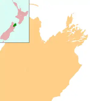
Picton, New Zealand
Picton (Māori: Waitohi) is a town in the Marlborough Region of New Zealand's South Island. The town is located near the head of the Queen Charlotte Sound / Tōtaranui, 25 km (16 mi) north of Blenheim and 65 km (40 mi) west of Wellington. Waikawa lies just north-east of Picton.
Picton
Waitohi (Māori) | |
|---|---|
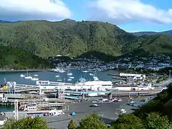 A view of the harbour in Picton | |
 Picton | |
| Coordinates: 41°17′34″S 174°0′21″E | |
| Country | New Zealand |
| Region | Marlborough |
| Area | |
| • Total | 9.16 km2 (3.54 sq mi) |
| Population (June 2020) | |
| • Total | 4,730 |
| • Density | 520/km2 (1,300/sq mi) |
| Postcode(s) | 7220 |
Picton is a major hub in New Zealand's transport network, connecting the South Island road and rail network with ferries across Cook Strait to Wellington and the North Island. The Picton urban area has a population of 4,730 (June 2020),[1] making it the second-largest town in the Marlborough Region behind Blenheim. It is the easternmost town in the South Island with a population of at least 1,000 people.
Toponomy
The town is named after Sir Thomas Picton, the Welsh military associate of the Duke of Wellington, who was killed at the Battle of Waterloo.
Thomas Picton's connection to the slave trade and controversial governorship of Trinidad has resulted in calls for places named after him to be renamed.[2][3][4]
History
Prior to European settlement, the Te Atiawa o Te Waka-a-Māui iwi occupied Waitohi Pā on the site of the present town. In March 1850, Sir George Grey and Sir Francis Dillon purchased the land from Te Āti Awa, who moved to neighbouring Waikawa Bay. In 1859, the Marlborough Province was created and the newly-named Picton became the provincial capital. The provincial capital was moved to Blenheim in 1865.[5][6]
Author Katherine Mansfield spent time in Picton where her grandparents, Arthur and Mary Beauchamp, and her father Harold, lived for some time when they came from Australia. She included a reference to the port in her short story "The Voyage" (in the collection The Garden Party), which is "an account of a trip to Picton from Wellington on the Cook Strait ferry".[7][8]
The roll-on/roll-off (RORO) road and rail ferry service between Picton and Wellington started on 11 August 1962, operated by the New Zealand Railways Department with the ship GMV Aramoana.[9]
Geography
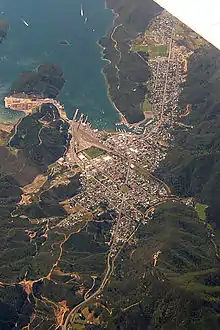
Picton is located in an inlet known as Picton Harbour, on the true right (south) side of the upper Queen Charlotte Sound / Tōtaranui. Picton Harbour is flanked to the west by Wedge Point, which separates it from Grove Arm, and to the east by The Snout, which separates it from Waikawa Bay. Within the harbour, Kaipupu Point splits the inlet into two, Picton Harbour proper to the east and Shakespeare Bay to the west.[10]
The main town is located on flat to rolling land at the head of Picton Harbour. Waitohi River starts in Essons Valley and passes through the town, draining into the sound near the ferry terminal. The township extends northeast along rolling land towards Waikawa Bay, separated from Picton Harbour by The Snout and Victoria Domain.[10]
On the land side, Picton is surrounded by hills and monutains, including Te Tara-o-Te-Marama / Mount Freeth to the west, the Robertson Range to the south and Mount McCormick to the east. The Elevation Saddle connects southwest of the town with the Tuamarina River valley and contains the main land transport routes between Picton and the rest of the South Island.
Demographics
The Picton urban area, comprising the statistical areas of Waitohi and Waikawa, covers an area of 9.16 km2 (3.54 sq mi).[11] It had a usual resident population of 4,500 at the 2018 New Zealand census, an increase of 486 people (12.1%) since the 2013 census, and an increase of 453 people (11.2%) since the 2006 census. There were 2,277 males and 2,223 females, giving a sex ratio of 1.02 males per female. Of the total population, 582 people (12.9%) were aged up to 15 years, 507 (11.3%) were 15 to 29, 2,031 (45.1%) were 30 to 64, and 1,380 (30.7%) were 65 or older.[12]
Ethnicities were 87.9% European/Pākehā, 18.3% Māori, 1.9% Pacific peoples, 2.4% Asian, and 1.9% other ethnicities (totals add to more than 100% since people could identify with multiple ethnicities).[12]
| SA2 name | Population | Dwellings | Median age | Median income |
|---|---|---|---|---|
| Waikawa | 1,464 | 795 | 57.4 years | $30,200 |
| Waitohi | 3,039 | 1,632 | 54.0 years | $25,000 |
Marae
Waikawa Marae is located in Picton. It is the marae (meeting ground) of Te Atiawa o Te Waka-a-Māui, and includes the Arapaoa wharenui (meeting house).[14][15]
In October 2020, the Government committed $242,386 from the Provincial Growth Fund to upgrade the marae, creating 18 jobs.[16]
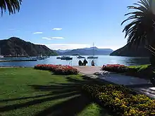
Attractions
The town is also the usual starting point for holidays in the Marlborough Sounds. Highlights include fishing, walking, the Queen Charlotte Track, and diving. A popular dive trip is to the 177-metre long wreck of the cruise liner MS Mikhail Lermontov, which lies at Port Gore, 37 metres underwater.[17] Dive charter boats leave from Picton for the last resting place of the Mikhail Lermontov, one of the world’s largest, most accessible and most recent shipwrecks. Guiding is essential as the 1986 wreck is in 30 metres of water and divers can become disoriented inside the hull, which lies on its starboard side.[18]
The completion of the highway link south ended the relative isolation of this scenic area in the 1950s and encouraged modern motels, beginning with the American Luxury Motels, and many more after the ferry service to Wellington began.
Other dive sites in the Picton region[19] include Fish Reserve, the Koi wreck, and Long Island Marine Reserve. Introductory dives (discover scuba dive) and PADI (Professional Association of Diving Instructors) certification courses from open water diver to dive master are available from Picton.[20] Technical diving and TDI (Technical Diving International) courses can be completed in Picton, diving in the Marlborough Sounds.
The Edwin Fox Maritime Centre features the remains of the Edwin Fox, the only surviving ship that transported convicts to Australia, and a small museum.
Infrastructure
Transport
State Highway 1 links Picton southwards to Blenheim, Kaikoura, Christchurch and beyond, while the scenic Queen Charlotte Drive (shorter in distance but usually slower than via State Highways 1, 62 and 6) winds westward to Havelock.

The Main North Line railway opened on 17 November 1875 between Picton and the Opaōa River just north of Blenheim (the bridge over the river wasn't completed until 1880). The full line south to Kaikōura and on to Christchurch wasn't completed until 15 December 1945. The line's climb from Picton to Elevation saddle required a steep 1-in-37 (2.7%) grade and a viaduct across the Waitohi River. The original viaduct was the largest wooden structure in the southern hemisphere at the time of its completion, and lasted until 1963 when it was replaced by the current concrete and steel structure. The original Picton railway station was located on London Quay; the platform still exists, bisected by the Memorial Archway steps.[21] The current station on Auckland Street was completed in 1914. It is a standard class B station, of weatherboard and tile,[22] and has been listed NZHPT Category II since 1991.[23] The Coastal Pacific long-distance passenger/tourist train from Christchurch makes a daily return trip to Picton during the summer months.
Roll-on/roll-off (RORO) ferries link Picton with Wellington, forming the main link between the North and South Islands across Cook Strait. The two main shipping companies operating this route are the Interislander and Strait Shipping, with both taking passenger and road vehicles, and, for the Interislander on one ferry, rail wagons. There have been proposals in recent years (the latest in 2011) to relocate the ferry terminals from Picton to Clifford Bay, south of Blenheim, to reduce travel times. However these plans never got past the design proposal, and were eventually dropped.[24] In 2019, consultation began on a redevelopment of the ferry precinct ahead of Interislander introducing new and larger ferries in 2024.[25][26]
Cruise ships regularly visit Picton between October and April. During the 2018-19 season, 44 ships carrying 85,000 passengers visited Picton.[27]
Picton Aerodrome at Koromiko 7.4 km to the south of the town has regular services to Wellington with Sounds Air and charter flights around the Marlborough sounds.
Water supply and sanitation
Picton's main water supply is from a bore at Speeds Road in Koromiko; during high demand, this is supplemented by a stream-fed supply in Essons Valley. The average daily water demand in the town is 3,800 m3 (130,000 cu ft), with demand in summer peaking at 5,770 m3 (204,000 cu ft).[28]
Prior to the commissioning of the Picton wastewater treatment plant in 1999, all the town's sewage was discharge raw into Queen Charlotte Sound. The town's wastewater system was upgraded in 2017, with a replacement main along Waikawa Road between Waikawa and central Picton and a bypass treatment plant to treat excess sewage that can't be processed at the main treatment plant.[29][30]
Education
The first school in Picton opened in 1861 at the corner of Devon Street and Broadway. A new school opened in 1882, and part of the old school was moved to the new site, but was destroyed by fire in 1928. A Catholic Convent school opened in 1915, and was replaced by St Joseph's in 1924.[31] St Joseph's closed in 2017 due to a declining school roll.[32]
Today, Picton has three schools:[33]
- Picton School is a state contributing primary (Year 1 to 6) school with a roll of approximately 104 students.
- Queen Charlotte College is a state Year 7 to 13 secondary school. It opened in 1965 and has a roll of approximately 374 students.
- Waikawa Bay School is a state contributing primary (Year 1 to 6) school in Waikawa with a roll of approximately 124 students.
Notable people
- Judith Adams - Australian politician
- Lance Cairns - Champion All-rounder for the New Zealand cricket team
- Chris Cairns - Cricketer
- Kip Colvey - Professional footballer with Colorado Rapids and the New Zealand national football team
- Nigel Hutchinson – Film producer and television commercial director[34]
- Tony Johnson - New Zealand rugby broadcaster
- Nelle Scanlan - Best-selling New Zealand novelist of the 1930s
- Joseph Sullivan - Double Sculls Gold Medalist at the London 2012 Olympic Games
- William Henry Woodgate - Last person hanged in Marlborough
References
- "Population estimate tables - NZ.Stat". Statistics New Zealand. Retrieved 22 October 2020.
- MacManus, Joel (11 June 2020). "Calls for colonial statues to go start to pick up in New Zealand". Stuff. Archived from the original on 12 June 2020.
- Bond, Jordan (12 June 2020). "Hamilton statue's removal raises debate over artefacts of British colonialism". Radio New Zealand. Archived from the original on 12 June 2020. Retrieved 12 June 2020.
- "Calls to rethink name 'Picton' as history emerges of 'cruel' slave-owner". Stuff. 2020-06-12. Retrieved 2020-06-14.
- Taonga, New Zealand Ministry for Culture and Heritage Te Manatu. "Picton". teara.govt.nz. Retrieved 2020-10-10.
- "Sir Thomas Picton (1758-1815) and the naming of Picton". www.theprow.org.nz. Retrieved 2020-10-10.
- "Kennedy, Julie". Wellington, New Zealand: Book Council. Retrieved 2010-07-21.
- Kennedy, Julie (2000). Katherine Mansfield in Picton. Auckland: Cape Catley. ISBN 0-908561-73-3.
- "Picton ferry Aramoana enters service | NZHistory, New Zealand history online". nzhistory.govt.nz. Retrieved 2020-10-11.
- Taonga, New Zealand Ministry for Culture and Heritage Te Manatu. "Picton". teara.govt.nz. Retrieved 2020-10-10.
- "Urban Rural 2020 (generalised) - GIS | | GIS Map Data Datafinder Geospatial Statistics | Stats NZ Geographic Data Service". datafinder.stats.govt.nz. Retrieved 2020-10-10.
- "Age and sex by ethnic group (grouped total response), for census usually resident population counts, 2006, 2013, and 2018 Censuses (urban rural areas)". nzdotstat.stats.govt.nz. Retrieved 2020-09-13.
- "2018 Census place summaries | Stats NZ". www.stats.govt.nz. Retrieved 2020-12-14.
- "Te Kāhui Māngai directory". tkm.govt.nz. Te Puni Kōkiri.
- "Māori Maps". maorimaps.com. Te Potiki National Trust.
- "Marae Announcements" (Excel). growregions.govt.nz. Provincial Growth Fund. 9 October 2020.
- Wreck Diving in the Marlborough Sounds New Zealand. Mikhail Lermontov, Lastingham, Koi and Rangitoto : Go Dive Marlborough
- Charter Information Marlborough (NZ): Yacht, Launch & Boat Charters and Deep Sea Diving
- Wreck and reef dive sites in the Marlborough Sounds including the Mikhail Lermontov, Lastingham, and Rangitoto wrecks
- New Zealand Wreck Diving in the Marlborough Sounds, Diver Training, Liveaboard and live ashore expeditions. PADI accredited scuba diving and dive tourism instruction
- "Heritage: The early days of rail in Marlborough". Stuff. 2017-07-13. Retrieved 2020-10-10.
- Rail Heritage Trust - Picton
- "Search the List | Picton Railway Station | Heritage New Zealand". www.heritage.org.nz. Retrieved 2020-10-10.
- Vernon Small; Cathie Bell (14 November 2013). "Cook Strait ferry terminal stays in Picton". Marlborough Express. Stuff.co.nz. Retrieved 7 June 2016.
- "Picton Ferry Precinct Redevelopment | Providing great journeys & secure freight connections". Picton Ferry Precinct Redevelopment. Retrieved 2020-10-12.
- "Picton ferry terminal upgrade to be fast-tracked". Stuff. 2020-06-15. Retrieved 2020-10-12.
- "Ready or not? Record-breaking cruise ship season forecasted for Picton". Stuff. Retrieved 2020-01-22.
- "Picton Water Supply - Marlborough District Council". www.marlborough.govt.nz. Retrieved 2020-10-07.
- "THE NEW PICTON HARBOUR WASTEWATER OUTFALL-A CLEAR AND EFFECTIVE SOLUTION".
- "Picton sewerage system gets further upgrades". Stuff. 2017-05-26. Retrieved 2020-10-07.
- A. D. McIntosh, ed. (1940). Marlborough - A Provincial History. pp. 329, 340–342.
- "Pin pulled on Picton's two-pupil school". Stuff. 2017-06-06. Retrieved 2020-10-10.
- "New Zealand Schools Directory". New Zealand Ministry of Education. Retrieved 26 April 2020.
- Croot, James (2017-03-27). "Goodbye Pork Pie producer Nigel Hutchinson dies, aged 75". Stuff.co.nz. Retrieved 2017-04-19.
External links
| Wikivoyage has a travel guide for Picton. |