Pilat Regional Natural Park
Pilat Regional Natural Park (French: Parc naturel régional du Pilat) is a protected area of mountainous countryside in the Rhône-Alpes region of southeastern France. The park spans the departments of Loire and Rhône, and covers a total area of 65,000 hectares (160,000 acres).[1]
| Pilat Regional Natural Park | |
|---|---|
 | |
| Location | Rhône-Alpes, Loire Rhône, France |
| Governing body | Fédération des parcs naturels régionaux de France |
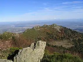
The mountain terrain ranges from 140 metres (460 ft) to 1,432 metres (4,698 ft) in elevation.[2] Forty-seven communes dot the landscape,[3] with approximately fifty thousand residents.[2] The land was officially designated a regional natural park in 1974.[1]
.jpg.webp)
Saint-Appolinard commune, Massif Pilat in background
Member communes
The park includes 47 member communes:[4]
References
- IUCN Commission on National Parks and Protected Areas (November 1990). 1990 United Nations list of national parks and protected areas. IUCN. p. 89. ISBN 978-2-8317-0032-8. Retrieved 26 August 2011.
- "The remarkable region of Pilat". Parc du Pilat. 2011. Retrieved 2 September 2011.
- "Pilat FAQ" (in French). Parc du Pilat. 2011. Retrieved 2 September 2011.
- "Les communes du Pilat" (in French). Parc-naturel-pilat.fr. 2011. Retrieved 29 October 2011.
This article is issued from Wikipedia. The text is licensed under Creative Commons - Attribution - Sharealike. Additional terms may apply for the media files.