Saint-Genest-Malifaux
Saint-Genest-Malifaux is a small town in the Auvergne-Rhône-Alpes region of central France. Administratively it is designated a commune within the department of Loire.
Saint-Genest-Malifaux | |
|---|---|
Commune | |
 | |
.svg.png.webp) Coat of arms | |
Location of Saint-Genest-Malifaux 
| |
 Saint-Genest-Malifaux  Saint-Genest-Malifaux | |
| Coordinates: 45°20′27″N 4°25′14″E | |
| Country | France |
| Region | Auvergne-Rhône-Alpes |
| Department | Loire |
| Arrondissement | Saint-Étienne |
| Canton | Le Pilat |
| Intercommunality | Monts du Pilat |
| Government | |
| • Mayor (2014–2020) | Vincent Ducreux |
| Area 1 | 47.08 km2 (18.18 sq mi) |
| Population (2017-01-01)[1] | 2,861 |
| • Density | 61/km2 (160/sq mi) |
| Time zone | UTC+01:00 (CET) |
| • Summer (DST) | UTC+02:00 (CEST) |
| INSEE/Postal code | 42224 /42660 |
| Elevation | 680–1,292 m (2,231–4,239 ft) (avg. 960 m or 3,150 ft) |
| 1 French Land Register data, which excludes lakes, ponds, glaciers > 1 km2 (0.386 sq mi or 247 acres) and river estuaries. | |
Population
|
|
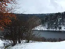
Lake at Saint-Genest-Malifaux

Mayor Vincent Ducreux, June 2013.
See also
References
- "Populations légales 2017". INSEE. Retrieved 6 January 2020.
| Wikimedia Commons has media related to Saint-Genest-Malifaux. |
| Authority control |
|
|---|
This article is issued from Wikipedia. The text is licensed under Creative Commons - Attribution - Sharealike. Additional terms may apply for the media files.