La Terrasse-sur-Dorlay
La Terrasse-sur-Dorlay (French pronunciation: [la tɛʁas syʁ dɔʁlɛ]) is a commune in the Loire department in central France.
La Terrasse-sur-Dorlay | |
|---|---|
Commune | |
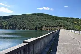 Dam on the Dorlay | |
.svg.png.webp) Coat of arms | |
Location of La Terrasse-sur-Dorlay 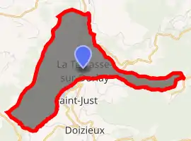
| |
 La Terrasse-sur-Dorlay  La Terrasse-sur-Dorlay | |
| Coordinates: 45°26′57″N 4°35′02″E | |
| Country | France |
| Region | Auvergne-Rhône-Alpes |
| Department | Loire |
| Arrondissement | Saint-Étienne |
| Canton | Le Pilat |
| Intercommunality | Saint-Étienne Métropole |
| Government | |
| • Mayor (2020–2026) | Christian Ducceschi |
| Area 1 | 8.69 km2 (3.36 sq mi) |
| Population (2017-01-01)[1] | 785 |
| • Density | 90/km2 (230/sq mi) |
| Time zone | UTC+01:00 (CET) |
| • Summer (DST) | UTC+02:00 (CEST) |
| INSEE/Postal code | 42308 /42740 |
| Elevation | 400–873 m (1,312–2,864 ft) |
| 1 French Land Register data, which excludes lakes, ponds, glaciers > 1 km2 (0.386 sq mi or 247 acres) and river estuaries. | |
La Terrasse-sur-Dorlay takes its name from the Dorlay river, a tributary of the Gier, which flows through the commune.
Population
| Year | Pop. | ±% |
|---|---|---|
| 1906 | 664 | — |
| 1911 | 662 | −0.3% |
| 1921 | 587 | −11.3% |
| 1931 | 566 | −3.6% |
| 1946 | 375 | −33.7% |
| 1954 | 442 | +17.9% |
| 1962 | 462 | +4.5% |
| 1968 | 500 | +8.2% |
| 1975 | 465 | −7.0% |
| 1982 | 520 | +11.8% |
| 1990 | 545 | +4.8% |
| 1999 | 653 | +19.8% |
| 2010 | 765 | +17.2% |
| 2017 | 785 | +2.6% |
Sights
The dam on the Dorlay with storage capacity of 2,500,000 cubic metres (88,000,000 cu ft), is just upstream from the village.[2]
References
- "Populations légales 2017". INSEE. Retrieved 6 January 2020.
- CESAME (March 2010). "Prélèvements et gestion quantitative de la ressource sur le bassin versant du Gier Phase 1" (PDF). Saint-Etienne Metropole. p. 6. Archived from the original (PDF) on 2016-03-04. Retrieved 2012-08-20.
See also
| Wikimedia Commons has media related to La Terrasse-sur-Dorlay. |
| Authority control |
|---|
This article is issued from Wikipedia. The text is licensed under Creative Commons - Attribution - Sharealike. Additional terms may apply for the media files.