Podveža
Podveža (pronounced [pɔˈdʋɛːʒa]) is a dispersed settlement of isolated farmsteads and highland pastures in the Municipality of Luče in Slovenia. The area belongs to the traditional region of Styria and is now included in the Savinja Statistical Region.[2] It encompasses the Dleskovec Plateau.
Podveža | |
|---|---|
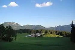 The Planinšek Farm in Podveža is the highest-lying farm on the Dleskovec Plateau. | |
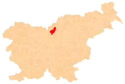
 Podveža Location in Slovenia | |
| Coordinates: 46°21′7.86″N 14°43′19.01″E | |
| Country | |
| Traditional region | Styria |
| Statistical region | Savinja |
| Municipality | Luče |
| Area | |
| • Total | 38.39 km2 (14.82 sq mi) |
| Elevation | 825.2 m (2,707.3 ft) |
| Population (2012) | |
| • Total | 148 |
| • Density | 4/km2 (10/sq mi) |
| [1] | |
References
- "Podveža, Luče". Place Names. Statistical Office of the Republic of Slovenia. Retrieved 20 August 2012.
- Luče municipal site
External links
 Media related to Podveža at Wikimedia Commons
- Podveža on Geopedia
| Settlements | Administrative centre: Luče
|  |
|---|---|---|
| Landmarks |
| |
This article is issued from Wikipedia. The text is licensed under Creative Commons - Attribution - Sharealike. Additional terms may apply for the media files.