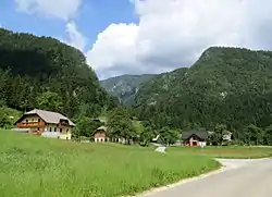
Podvolovljek
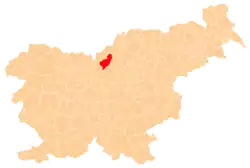
Podvolovljek (pronounced [pɔdʋɔˈloːu̯jɛk]) is a settlement in the Municipality of Luče in Slovenia. The area belongs to the traditional region of Styria and is now included in the Savinja Statistical Region.[2]
Podvolovljek | |
|---|---|
 | |
 Podvolovljek Location in Slovenia | |
| Coordinates: 46°18′21.15″N 14°41′49.64″E | |
| Country | |
| Traditional region | Styria |
| Statistical region | Savinja |
| Municipality | Luče |
| Area | |
| • Total | 18.9 km2 (7.3 sq mi) |
| Elevation | 646.7 m (2,121.7 ft) |
| Population (2019) | |
| • Total | 234 |
| [1] | |
Name
The name Podvolovljek is a fused prepositional phrase that has lost case inflection, from pod 'below' + Volovljek. Volovljek is a mountain pass at 1,029 meters (3,376 ft) south of the settlement as well as the name of a creek that flows south from a spring east of the pass.[3] The name Volovljek is derived from the common noun vol 'ox'. The pass was recorded as Ochsenperg (literally, 'ox mountain') in 1278.[4]
Church
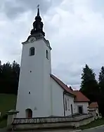
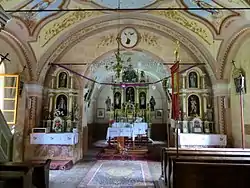
The local church is dedicated to Saint Anthony the Hermit and belongs to the Parish of Luče. It was first mentioned in written documents dating to 1631.[5]
References
- Statistical Office of the Republic of Slovenia
- Luče municipal site
- "Volovljek". Geopedia. Retrieved May 28, 2018.
- Snoj, Marko (2009). Etimološki slovar slovenskih zemljepisnih imen. Ljubljana: Modrijan. p. 464.
- Slovenian Ministry of Culture register of national heritage reference number 3126
External links
| Settlements | Administrative centre: Luče
|  |
|---|---|---|
| Landmarks |
| |