Ponshewaing, Michigan
Ponshewaing is an unincorporated community and census-designated place (CDP) in Emmet County in the U.S. state of Michigan. As of the 2010 census, the CDP had a population of 69.[1] It is located within Littlefield Township.
Ponshewaing, Michigan | |
|---|---|
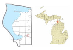 Location within Emmet County | |
 Ponshewaing Location within the state of Michigan  Ponshewaing Ponshewaing (the United States) | |
| Coordinates: 45°25′15″N 84°48′15″W | |
| Country | United States |
| State | Michigan |
| County | Emmet |
| Township | Littlefield |
| Area | |
| • Total | 0.09 sq mi (0.2 km2) |
| • Land | 0.09 sq mi (0.2 km2) |
| • Water | 0.0 sq mi (0 km2) |
| Elevation | 610 ft (186 m) |
| Population (2010) | |
| • Total | 69 |
| • Density | 766.7/sq mi (296.0/km2) |
| Time zone | UTC-5 (Eastern (EST)) |
| • Summer (DST) | UTC-4 (EDT) |
| ZIP code(s) | 49706 (Alanson) |
| Area code(s) | 231 |
| FIPS code | 26-65420[1] |
| GNIS feature ID | 635223[2] |
Geography
Ponshewaing is located in southeastern Emmet County, in Littlefield Township, on the north shore of Crooked Lake. It is bordered to the west by Oden. U.S. Route 31 passes through the community, leading southwest 9 miles (14 km) to Petoskey, the county seat, and northeast 2 miles (3 km) to Alanson.
The community of Ponshewaing was listed as a newly-organized census-designated place for the 2010 census, meaning it now has officially defined boundaries and population statistics for the first time.[3]
According to the U.S. Census Bureau, the Ponshewaing CDP has a total area of 0.09 square miles (0.23 km2), all land.[1] Of Michigan's 159 census-designated places, Ponshewaing ranks as the smallest in terms of land area and fourth smallest in terms of population.[3]
References
- "Geographic Identifiers: 2010 Demographic Profile Data (G001): Ponshewaing CDP, Michigan". U.S. Census Bureau, American Factfinder. Retrieved February 12, 2016.
- U.S. Geological Survey Geographic Names Information System: Ponshewaing, Michigan
- "Michigan: 2010 Population and Housing Unit Counts 2010 Census of Population and Housing" (PDF). 2010 United States Census. United States Census Bureau. September 2012. p. III-5. Retrieved February 29, 2020.
Municipalities and communities of Emmet County, Michigan, United States | ||
|---|---|---|
| Cities | 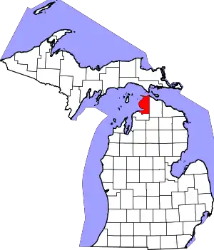 Map of Michigan highlighting Emmet County.svg | |
| Villages | ||
| Civil township | ||
| CDPs | ||
| Ghost towns | ||
| Indian reservations | ||
| Footnotes | ‡This populated place also has portions in an adjacent county or counties | |
| ||