Ponta Garça
Ponta Garça is a civil parish in the municipality of Vila Franca do Campo in the Portuguese archipelago of the Azores. The population in 2011 was 3,547,[1] in an area of 29.35 km².[2] It is the largest parish in Vila Franca do Campo.
Ponta Garça | |
|---|---|
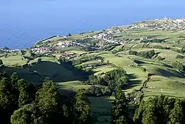 Partial view of the parish of Ponta Garça, considered the longest parish on the island of São Miguel | |
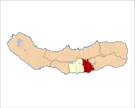 Location of the civil parish of Ponta Garça in the municipality of Vila Franca do Campo | |
| Coordinates: 37°43′7″N 25°22′12″W | |
| Country | |
| Auton. region | Azores |
| Island | São Miguel |
| Municipality | Vila Franca do Campo |
| Established | Settlement: fl. 1500 |
| Area | |
| • Total | 29.35 km2 (11.33 sq mi) |
| Elevation | 123 m (404 ft) |
| Population (2011) | |
| • Total | 3,547 |
| • Density | 120/km2 (310/sq mi) |
| Time zone | UTC−01:00 (AZOT) |
| • Summer (DST) | UTC±00:00 (AZOST) |
| Postal code | 9680-447 |
| Area code | 292 |
| Patron | Nossa Senhora da Piedade |
| Website | jfpontagarca |
History
Gaspar Frutuoso indicated that the origin of its toponymy was connected with the first settlers' reflections on sighting this zone.[3] On the other hand, the local civil parish council claims that the area was named for the preponderance of marine birds, that nest on the cliffs of the parish.[3]
The civil parish was first designated in the 16th century, likely owing to the communities growth and access to potable water.[3]
Geography
The parish is located along the main regional roadway that links Lagoa and Ponta Delgada with the eastern part of the island. It is situated in the eastern part of Vila Franca do Campo. It contains the localities Cinzeiro, Meio Moio, Ponta Garça and Senhora das Mercês. Ponta Garça has 3 elementary schools, and a church.
Economy
The main industry are agriculture and manufacturing.
Architecture
Civic
- Estate of the Viscount Botelho (Portuguese: Solar Visconde Botelho)[4]
- Lighthouse of Ponta Garça (Portuguese: Farol de Ponta Garça), the 20th century lighthouse includes a single circular tower and main block, similar to other modernist structures of this type, such as the lighthouse of Ponta dos Rosais;[5] considered emblematic of the region, it was constructed in 1957, and includes a 14 metres (46 ft) tower, with view of the sea and parish.[4]
Religious
- Church of Nossa Senhora da Piedade (Portuguese: Igreja Paroquial de Ponta Garça/Igreja de Nossa Senhora da Piedade)[4]
- Hermitage of Senhora das Mercês (Portuguese: Ermida da Senhora das Mercês), situated in Grotas Fundas, this hermitage dates from the 18th century, and includes an image in high-relief dating from the same period.[4]
References
- Instituto Nacional de Estatística
- Eurostat
- Janta Freguesia, ed. (2010), Historial (in Portuguese), Junta Freguesia de Ponta Garça, retrieved 11 February 2013
- Junta Freguesia, ed. (2013), Património (in Portuguese), Ponta Garça (Vila Franca do Campo), Portugal: Junta Freguesia de Ponta Garça, retrieved 6 March 2014
- Costa, Patrícia; Noé, Paula (2010), SIPA (ed.), Farol da Ponta da Garça (IPA.00015923/PT072106020007) (in Portuguese), Lisbon, Portugal: SIPA – Sistema de Informação para o Património Arquitectónico, retrieved 4 March 2014