Port Neville
Port Neville is a bay, port and locality on the north side of Johnstone Strait, south of Call Inlet,[1] in the Central Coast region of British Columbia, Canada.
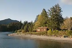
The locality of Port Neville, which had a post office until 2013, to is located on the east side of the narrows that form the opening into Johnstone Strait of the port, which is really an inlet, at 50°30′00″N 126°05′00″W.[2]
Port Neville Indian Reserve No. 4, or Port Neville 4, is located at the upper end of the port, to the south of Fulmore Lake at 50°34′00″N 125°56′00″W[3] It is 14.9 ha. in size and is under the governance of the Tlowitsis Tribe band government of the Kwakwaka'wakw peoples.[4] It is one of 11 reserves governed by the Tlowitsis,[5] another of which is also on Port Neville, Hanatsa Indian Reserve No. 6, or Hanatsa 6, 95.1 ha. in size, is located on the south shore of the upper end of Port Neville[6] at 50°32′00″N 125°58′00″W,[7] to the east of Hanatsa Point at 50°31′47″N 125°59′54″W,[8] which is at a narrows between the upper end of the port and the wider area towards its opening.
On the east shore of the port is xudzedzalis, a fort utilized by the Matilpi group of Kwakwaka'wakw.[9] at 50°31′20″N 126°03′40″W. Its name means "fort on flat on beach".
This "very snug and commodious port" was named by Captain Vancouver probably in honour of Lieutenant John Neville of the Royal Marines but there is doubt about who he referred to.[10]:212
See also
- List of settlements in British Columbia
References
- BC Names/GeoBC entry "Port Neville (port)"
- BC Names/GeoBC entry "Port Neville (locality)"
- BC Names/GeoBC entry "Port Neville 4 (Indian reserve)"
- Indian and Northern Affairs Canada, Reserve/Settlement Village Detail Archived 2014-05-05 at the Wayback Machine
- "Indian and Northern Affairs Canada Reserves/Settlements/Villages Detail". Archived from the original on 2014-05-05. Retrieved 2014-05-05.
- Indian and Northern Affairs Canada Reserve/Settlement/Village Detail Archived 2014-05-05 at the Wayback Machine
- BC Names/GeoBC entry "Hanatsa 6 (Indian reserve)"
- BC Names/GeoBC entry "Hanatsa Point"
- BC Names/GeoBC entry "xudzedzalis (fort)"
- Akrigg, G.P.V.; Akrigg, Helen B. (1986), British Columbia Place Names (3rd, 1997 ed.), Vancouver: UBC Press, ISBN 0-7748-0636-2
