Porto Santo (Madeira)
Porto Santo is the only municipality of the island of Porto Santo, in the Portuguese Madeiran archipelago. It was elevated to city status on 6 August 1996. The only parish of the municipality is also named Porto Santo. The population in 2011 was 5,483,[1] in an area of 42.59 km².[2] The main settlement on the island is Vila Baleira.
Porto Santo | |
|---|---|
.jpg.webp) | |
 Coat of arms | |
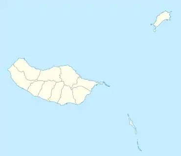 Porto Santo Location in Madeira | |
| Coordinates: 33°4′36″N 16°20′40″W | |
| Country | |
| Auton. region | Madeira |
| Island | Porto Santo |
| Established | Settlement: fl. 1500 Municipality: c. 1835 Town: 6 August 1996 |
| Parishes | 1 |
| Government | |
| • President | Filipe Oliveira de Menezes |
| Area | |
| • Total | 42.59 km2 (16.44 sq mi) |
| Elevation | 92 m (302 ft) |
| Population (2011) | |
| • Total | 5,483 |
| • Density | 130/km2 (330/sq mi) |
| Time zone | UTC±00:00 (WET) |
| • Summer (DST) | UTC+01:00 (WEST) |
| Postal code | 9400-000 |
| Area code | 291 |
| Website | www |
Climate
Porto Santo has a subtropical hot semi-arid climate (BSh) according to the Köppen climate classification, with very mild winters and warm summers. The annual average temperature is 18.6 °C (65 °F).
| Climate data for Porto Santo Island (1971–2000) | |||||||||||||
|---|---|---|---|---|---|---|---|---|---|---|---|---|---|
| Month | Jan | Feb | Mar | Apr | May | Jun | Jul | Aug | Sep | Oct | Nov | Dec | Year |
| Record high °C (°F) | 23.2 (73.8) |
22.6 (72.7) |
26.0 (78.8) |
26.4 (79.5) |
27.6 (81.7) |
30.5 (86.9) |
31.6 (88.9) |
35.3 (95.5) |
34.4 (93.9) |
28.6 (83.5) |
29.2 (84.6) |
23.3 (73.9) |
35.3 (95.5) |
| Average high °C (°F) | 18.0 (64.4) |
18.0 (64.4) |
18.5 (65.3) |
19.2 (66.6) |
20.5 (68.9) |
22.1 (71.8) |
23.5 (74.3) |
25.0 (77.0) |
25.0 (77.0) |
23.2 (73.8) |
21.0 (69.8) |
19.2 (66.6) |
21.1 (70.0) |
| Daily mean °C (°F) | 15.6 (60.1) |
15.5 (59.9) |
15.9 (60.6) |
16.5 (61.7) |
17.8 (64.0) |
19.6 (67.3) |
21.3 (70.3) |
22.5 (72.5) |
22.3 (72.1) |
20.6 (69.1) |
18.6 (65.5) |
16.8 (62.2) |
18.6 (65.5) |
| Average low °C (°F) | 13.2 (55.8) |
13.1 (55.6) |
13.3 (55.9) |
13.8 (56.8) |
15.1 (59.2) |
17.1 (62.8) |
18.8 (65.8) |
19.9 (67.8) |
19.6 (67.3) |
18.1 (64.6) |
16.2 (61.2) |
14.4 (57.9) |
16.1 (61.0) |
| Record low °C (°F) | 7.6 (45.7) |
6.4 (43.5) |
8.4 (47.1) |
8.8 (47.8) |
10.6 (51.1) |
12.3 (54.1) |
14.0 (57.2) |
16.2 (61.2) |
14.6 (58.3) |
12.4 (54.3) |
10.1 (50.2) |
7.5 (45.5) |
6.4 (43.5) |
| Average precipitation mm (inches) | 48.7 (1.92) |
40.2 (1.58) |
37.2 (1.46) |
23.5 (0.93) |
14.0 (0.55) |
7.0 (0.28) |
3.2 (0.13) |
4.0 (0.16) |
23.7 (0.93) |
39.9 (1.57) |
50.0 (1.97) |
69.9 (2.75) |
361.3 (14.22) |
| Average precipitation days (≥ 0.1 mm) | 13.7 | 12.2 | 10.9 | 10.4 | 8.5 | 6.7 | 4.8 | 4.6 | 7.4 | 12.0 | 12.5 | 15.1 | 118.8 |
| Average relative humidity (%) (at 9:00 UTC) | 79 | 80 | 78 | 75 | 75 | 76 | 76 | 76 | 77 | 78 | 79 | 79 | 77 |
| Mean monthly sunshine hours | 134.9 | 134.5 | 171.0 | 188.4 | 223.3 | 203.9 | 223.0 | 241.4 | 203.8 | 182.1 | 146.3 | 132.9 | 2,185.5 |
| Source: Instituto Português do Mar e da Atmosfera[3] | |||||||||||||
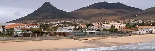
Vila Baleira, Porto Santo's capital
References
- Instituto Nacional de Estatística
- Eurostat
- "PORTO SANTO/AEROPORTO/MADEIRA (524)" (PDF). Fichas Climatológicas 1971-2000 (in Portuguese). Instituto Português do Mar e da Atmosfera. Archived from the original (PDF) on 30 March 2020. Retrieved 30 March 2020.
External links
 Media related to Porto Santo at Wikimedia Commons
| Madeira Island | ||
|---|---|---|
| Porto Santo Island | ||
| Authority control |
|
|---|
This article is issued from Wikipedia. The text is licensed under Creative Commons - Attribution - Sharealike. Additional terms may apply for the media files.