Potters Hill, North Carolina
Potters Hill is an unincorporated community and census-designated place (CDP) in Duplin County, North Carolina, United States.[2][3] As of the 2010 United States Census, Potters Hill had a population of 481 and a land area of 5.35 square miles (13.9 km2).[1]
Potters Hill, North Carolina | |
|---|---|
 Potters Hill Location within the state of North Carolina | |
| Coordinates: 34°58′6″N 77°42′38″W | |
| Country | United States |
| State | North Carolina |
| County | Duplin |
| Area | |
| • Total | 5.3 sq mi (13.8 km2) |
| • Land | 5.3 sq mi (13.8 km2) |
| • Water | 0.0 sq mi (0.0 km2) |
| Elevation | 100 ft (30 m) |
| Population (2010) | |
| • Total | 481 |
| • Density | 90/sq mi (34.7/km2) |
| Time zone | UTC-5 (Eastern (EST)) |
| • Summer (DST) | UTC-4 (EDT) |
| Area code(s) | 910 |
| FIPS code | 37-53580[1] |
| GNIS feature ID | 1025627[2] |
Potters Hill is located in eastern Duplin County along North Carolina Highway 41, which leads northeast 5 miles (8 km) to U.S. Route 258 and southwest 5 miles (8 km) to NC 24 at Beulaville. The northeast edge of the Potters Hill CDP follows the Jones and Onslow County lines.
References
- "Geographic Identifiers: 2010 Demographic Profile Data (G001): Potters Hill CDP, North Carolina". U.S. Census Bureau, American Factfinder. Archived from the original on February 13, 2020. Retrieved December 1, 2015.
- "Potters Hill". Geographic Names Information System. United States Geological Survey.
- "Potters Hill Census Designated Place". Geographic Names Information System. United States Geological Survey.
Municipalities and communities of Duplin County, North Carolina, United States | ||
|---|---|---|
| Towns | 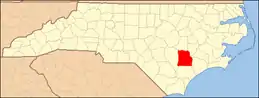 | |
| CDP | ||
| Other unincorporated communities | ||
| Footnotes | ‡This populated place also has portions in an adjacent county or counties | |
| ||
This article is issued from Wikipedia. The text is licensed under Creative Commons - Attribution - Sharealike. Additional terms may apply for the media files.