Pucaranra
Pucaranra[2][3][4][5] (possibly from Quechua puka red, ranra stony; stony ground,[6][7]) is a mountain in the Cordillera Blanca in the Andes of Peru, about 6,147 metres (20,167 ft) high[2] (although other sources cite an elevation of 6,156 metres (20,197 ft).[3][4][5] It is located in Ancash, southwest of mount Chinchey.[2][3]
| Pucaranra | |
|---|---|
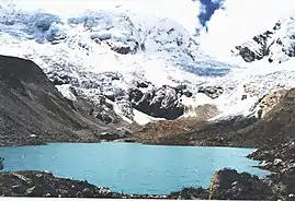 Palcaraju (on the left) and Pucaranra (on the right) behind Lake Palcacocha | |
| Highest point | |
| Elevation | 6,147 m (20,167 ft) |
| Coordinates | 9°23′30″S 77°21′03″W |
| Geography | |
 Pucaranra Peru | |
| Location | Peru, Ancash Region |
| Parent range | Andes, Cordillera Blanca |
| Climbing | |
| First ascent | 1948 via S.W. spur of S. ridge?: Variant on S.W. side-1954: E. slopes-1957: N.E. ridge-1959: S.W. ridge, S.W. face-1965: W. ridge-1977[1] |
| Easiest route | southeast ridge, AD |
Climbing
Several interesting lines on this mountain, none of them very serious but all requiring commitment. The east-northeast ridge is rated AD/D (depending on conditions), the southeast face AD+ and the southeast ridge AD.
References
- Jill Neate, Mountaineering in the Andes, 1994
- Díaz, Felipe (2008–2009). Carta Turística. Cordilleras Blanca, Negra, Huayhuash y Callejón de Huaylas.
- Alpenvereinskarte 0/3b. Cordillera Blanca Süd (Peru). 1:100 000. Oesterreichischer Alpenverein. 2005. ISBN 3-937530-05-3.
- Biggar, John (2020). The Andes: A Guide for Climbers and Skiers. Andes. p. 100. ISBN 9780953608768.
- "Nevado Pucaranra - Peakbagger.com". peakbagger.com. Retrieved 2016-06-18.
- Teofilo Laime Ajacopa, Diccionario Bilingüe Iskay simipi yuyayk'ancha, La Paz, 2007 (Quechua-Spanish dictionary)
- Diccionario Quechua - Español - Quechua, Academía Mayor de la Lengua Quechua, Gobierno Regional Cusco, Cusco 2005 (Quechua-Spanish dictionary)
This article is issued from Wikipedia. The text is licensed under Creative Commons - Attribution - Sharealike. Additional terms may apply for the media files.
