Pueblo, San Juan, Puerto Rico
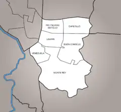
Río Piedras Pueblo, (officially just "Pueblo"), is one of 18 barrios in the municipality of San Juan, Puerto Rico.[3][4][5] It is made up of 6 subbarrios: Buen Consejo, Capetillo, Monte Rey, Río Piedras Antiguo, Ubarri, and Venezuela. Rio Piedras Pueblo is what used to be the urban center barrio of the former municipality of Río Piedras until 1951, when the municipality of Rio Piedras was absorbed by the municipality of San Juan.
Pueblo | |
|---|---|
Barrio | |
.jpg.webp) Cathedral in Río Piedras main square | |
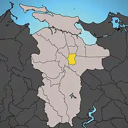 Location of Pueblo shown in yellow | |
| Coordinates: 18°23′38″N 66°02′52″W[1] | |
| Commonwealth | |
| Municipality | |
| Area | |
| • Total | 0.73 sq mi (1.9 km2) |
| • Land | 0.73 sq mi (1.9 km2) |
| • Water | 0 sq mi (0 km2) |
| Elevation | 207 ft (63 m) |
| Population (2010) | |
| • Total | 8,720 |
| • Density | 11,945.2/sq mi (4,612.1/km2) |
| 2010 census | |
| Time zone | UTC−4 (AST) |
In 2010, it had a population of 8,720 residing in land area of 0.73 sq. mi. (1.86 km2).
Rio Piedras Pueblo is bounded to the west by Hato Rey Sur and El Cinco, with Universidad barrio to the North, and with Sabana Llana Sur barrio to the south and east.
Demographics
| Historical population | |||
|---|---|---|---|
| Census | Pop. | %± | |
| 1980 | 8,821 | — | |
| 1990 | 8,804 | −0.2% | |
| 2000 | 9,391 | 6.7% | |
| 2010 | 8,720 | −7.1% | |
| U.S. Decennial Census[6] 1899 (shown as 1900)[7] 1910-1930[8] 1930-1950[9] 1980-2000[10] 2010[11] | |||
See also
References
- "US Gazetteer 2019". US Census. US Government.
- U.S. Geological Survey Geographic Names Information System: Pueblo barrio
- Picó, Rafael; Buitrago de Santiago, Zayda; Berrios, Hector H. Nueva geografía de Puerto Rico: física, económica, y social, por Rafael Picó. Con la colaboración de Zayda Buitrago de Santiago y Héctor H. Berrios. San Juan Editorial Universitaria, Universidad de Puerto Rico,1969.
- Gwillim Law (20 May 2015). Administrative Subdivisions of Countries: A Comprehensive World Reference, 1900 through 1998. McFarland. p. 300. ISBN 978-1-4766-0447-3. Retrieved 25 December 2018.
- Puerto Rico:2010:population and housing unit counts.pdf (PDF). U.S. Dept. of Commerce, Economics and Statistics Administration, U.S. Census Bureau. 2010.
- "U.S. Decennial Census". United States Census Bureau. Archived from the original on February 13, 2020. Retrieved September 21, 2017.
- "Report of the Census of Porto Rico 1899". War Department Office Director Census of Porto Rico. Archived from the original on July 16, 2017. Retrieved September 21, 2017.
- "Table 3-Population of Municipalities: 1930 1920 and 1910" (PDF). United States Census Bureau. Archived (PDF) from the original on August 17, 2017. Retrieved September 21, 2017.
- "Table 4-Area and Population of Municipalities Urban and Rural: 1930 to 1950" (PDF). United States Census Bureau. Archived (PDF) from the original on August 30, 2015. Retrieved September 21, 2014.
- "Table 2 Population and Housing Units: 1960 to 2000" (PDF). United States Census Bureau. Archived (PDF) from the original on July 24, 2017. Retrieved September 21, 2017.
- Puerto Rico:2010:population and housing unit counts.pdf (PDF). U.S. Dept. of Commerce Economics and Statistics Administration U.S. Census Bureau. 2010. Archived (PDF) from the original on 2017-02-20. Retrieved 2019-08-02.
- "US Census definition of "subbarrio"". factfinder.com. US Census. Archived from the original on 12 February 2019. Retrieved 5 January 2019.
| ||
| Barrios | ||
This article is issued from Wikipedia. The text is licensed under Creative Commons - Attribution - Sharealike. Additional terms may apply for the media files.