San Juan Antiguo
San Juan Antiguo (not to be confused with the historic district of Old San Juan), is a barrio located in the municipality of San Juan in the Commonwealth of Puerto Rico. San Juan Antiguo has 7 subbarrios. In 2010, San Juan Antiguo had a population of 7,085 inhabitants and a population density of 2,681.9 people per km2.[1] San Juan Antiguo is located within the Isleta de San Juan, an island off the coast of Puerto Rico, connected to the mainland by bridges and a causeway.
San Juan Antiguo | |
|---|---|
Barrio | |
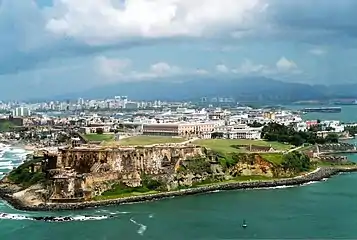 Aerial view of the northwest tip of San Juan Antiguo | |
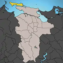 Location of San Juan Antiguo shown in yellow | |
| Coordinates: 18.46611°N 66.10884°W | |
| Commonwealth | |
| Municipality | |
| Area | |
| • Total | 2.63 sq mi (6.8 km2) |
| • Land | 1.02 sq mi (2.6 km2) |
| • Water | 0.61 sq mi (1.6 km2) |
| Elevation | 20 ft (6 m) |
| Population (2010) | |
| • Total | 7,085 |
| • Density | 6,946.1/sq mi (2,681.9/km2) |
| (US Census 2010) | |
| Time zone | UTC−4 (AST) |
History
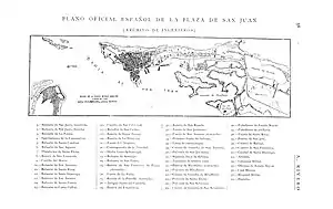
In the late 19th century, San Juan Antiguo called Plaza de San Juan is where Spain had its war fortifications and military buildings.
Puerto Rico was ceded by Spain in the aftermath of the Spanish–American War under the terms of the Treaty of Paris of 1898 and became an unincorporated territory of the United States.[2]
| Historical population | |||
|---|---|---|---|
| Census | Pop. | %± | |
| 1980 | 9,886 | — | |
| 1990 | 9,696 | −1.9% | |
| 2000 | 7,963 | −17.9% | |
| 2010 | 7,085 | −11.0% | |
| U.S. Decennial Census[3] 1899 (shown as 1900)[4] 1910-1930[5] 1930-1950[6] 1980-2000[7] 2010[8] | |||
Subbarrios
San Juan Antiguo is divided into the following subbarrios:[9]
Gallery
 Statue in Marina, a subbarrio of San Juan Antiguo
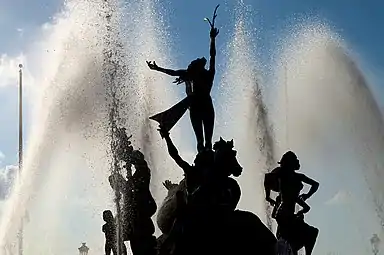
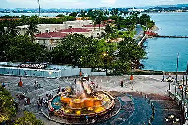 Fountain in San Juan Antiguo
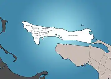 Subbarrios of San Juan Antiguo
References
- U.S. Gazetteer: 2010 Census . United States Census Bureau Retrieved on May 31, 2018
- Joseph Prentiss Sanger; Henry Gannett; Walter Francis Willcox (1900). Informe sobre el censo de Puerto Rico, 1899, United States. War Dept. Porto Rico Census Office (in Spanish). Imprenta del gobierno. p. 161.
- "U.S. Decennial Census". United States Census Bureau. Archived from the original on February 13, 2020. Retrieved September 21, 2017.
- "Report of the Census of Porto Rico 1899". War Department Office Director Census of Porto Rico. Archived from the original on July 16, 2017. Retrieved September 21, 2017.
- "Table 3-Population of Municipalities: 1930 1920 and 1910" (PDF). United States Census Bureau. Archived (PDF) from the original on August 17, 2017. Retrieved September 21, 2017.
- "Table 4-Area and Population of Municipalities Urban and Rural: 1930 to 1950" (PDF). United States Census Bureau. Archived (PDF) from the original on August 30, 2015. Retrieved September 21, 2014.
- "Table 2 Population and Housing Units: 1960 to 2000" (PDF). United States Census Bureau. Archived (PDF) from the original on July 24, 2017. Retrieved September 21, 2017.
- Puerto Rico:2010:population and housing unit counts.pdf (PDF). U.S. Dept. of Commerce Economics and Statistics Administration U.S. Census Bureau. 2010. Archived (PDF) from the original on 2017-02-20. Retrieved 2019-08-02.
- Puerto Rico: 2010 Population and housing unit counts (PDF). U.S. Dept. of Commerce, Economics and Statistics Administration, U.S. Census Bureau. 2010. p. 76.
External links
U.S. Geological Survey Geographic Names Information System: San Juan Antiguo
| ||
| Barrios | ||