Puerto Rico Highway 165
Puerto Rico Highway 165 (PR-165) is the road that goes from Naranjito to Guaynabo. The highway passes by Toa Alta, Toa Baja, Dorado, Levittown, Cataño and Guaynabo.[4]
| ||||
|---|---|---|---|---|
| Route information | ||||
| Maintained by Puerto Rico DTPW | ||||
| Length | 38.9 km[1][2] (24.2 mi) | |||
| Existed | 1953[3]–present | |||
| Major junctions | ||||
| West end | ||||
| ||||
| East end | ||||
| Location | ||||
| Municipalities | Naranjito, Toa Alta, Dorado, Toa Baja, Cataño, Guaynabo | |||
| Highway system | ||||
| ||||


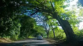
The PR-165 begins in the PR-164 (road from Naranjito to Corozal) and ends at San Patricio (near Caparra). From Naranjito to Toa Alta is a rural road. In Toa Baja becomes a divided highway. In Dorado the road is one lane in each direction and parallel to the northern coast of Puerto Rico. In Levittown becomes a divided highway before ending at San Patricio. In Cataño is a short highway which begins at the Bacardi Distillery and ends at the Federal Prison.
Major intersections
| Municipality | Location | km[1][2] | mi | Exit | Destinations | Notes |
|---|---|---|---|---|---|---|
| Naranjito | Lomas | 0.0 | 0.0 | Southern terminus of PR-165 | ||
| Toa Alta | Quebrada Cruz–Quebrada Arenas line | 4.7 | 2.9 | |||
| Quebrada Arenas–Quebrada Cruz– Galateo tripoint | 5.8 | 3.6 | ||||
| Galateo | 6.7– 6.8 | 4.2– 4.2 | ||||
| Contorno–Galateo line | 8.2 | 5.1 | ||||
| Contorno | 10.6 | 6.6 | ||||
| 10.7– 10.8 | 6.6– 6.7 | |||||
| 11.4– 11.5 | 7.1– 7.1 | Roundabout | ||||
| Dorado | Río Lajas | 11.8 | 7.3 | |||
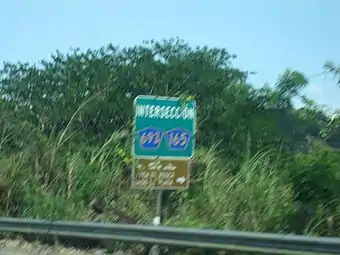
| 13.6 23.5[lower-alpha 1] | 8.5 14.6 | Western terminus of PR-2 concurrency | ||||
| Río de la Plata | 23.4[lower-alpha 1] | 14.5 | Puente de la Virgencita | |||
| Toa Baja | Media Luna | 22.9[lower-alpha 1] | 14.2 | |||
| 22.6[lower-alpha 1] 13.7 | 14.0 8.5 | 14 | Eastern terminus of PR-2 concurrency; trumpet interchange | |||
| 14.3– 14.7 | 8.9– 9.1 | 15 | PR-22 exits 22, 22A and 22B; partial cloverleaf interchange; southbound exits signed as 15A and 15B; no exit number northbound | |||
| 15.0 | 9.3 | |||||
| Media Luna–Sabana Seca line | 17.4 | 10.8 | ||||
| Dorado | Mameyal | 18.6 | 11.6 | |||
| Toa Baja | Sabana Seca | 26.7– 26.8 | 16.6– 16.7 | |||
| 29.6– 29.7 | 18.4– 18.5 | |||||
| Palo Seco | 31.1– 31.2 | 19.3– 19.4 | ||||
| Cataño | Palmas | 31.7– 31.8 | 19.7– 19.8 | |||
| 32.3– 32.4 | 20.1– 20.1 | |||||
| 34.5– 35.1 | 21.4– 21.8 | — | Diamond interchange | |||
| Guaynabo | Pueblo Viejo | 36.5– 36.9 | 22.7– 22.9 | — | ||
| 37.1– 37.2 | 23.1– 23.1 | |||||
| 37.4– 37.9 | 23.2– 23.5 | PR-22 exits 7A and 7B; partial cloverleaf interchange | ||||
| 38.9 | 24.2 | Northern terminus of PR-165 | ||||
1.000 mi = 1.609 km; 1.000 km = 0.621 mi
| ||||||
- Kilometer markers represent the distance along PR-2 rather than PR-165.
Related routes
Puerto Rico Highway 165R
| |
|---|---|
| Location | Toa Alta |
| Length | 0.65 km[5] (0.40 mi) |
Puerto Rico Highway 165R (PR-165R) is the road that goes to downtown Toa Alta, Puerto Rico. This road can be seen as the Business 165, since this road was the PR-165 through the area from the town center.[6] The entire route is located in Toa Alta.
| Location | km[5] | mi | Destinations | Notes | |
|---|---|---|---|---|---|
| Contorno | 0.00 | 0.00 | Southern terminus of PR-165R | ||
| Toa Alta barrio-pueblo | 0.65 | 0.40 | Northern terminus of PR-165R | ||
| 1.000 mi = 1.609 km; 1.000 km = 0.621 mi | |||||
Puerto Rico Highway 6165
| |
|---|---|
| Location | Dorado |
| Length | 0.78 km[7] (0.48 mi) |
Puerto Rico Highway 6165 (PR-6165) is the road that goes to downtown Dorado, Puerto Rico from PR-165. This road can be seen as the Business spur 165 because it connects PR-165 with PR-693 in downtown area.[6] The entire route is located in Dorado.
| Location | km[7] | mi | Destinations | Notes | |
|---|---|---|---|---|---|
| Dorado barrio-pueblo | 0.78 | 0.48 | Western terminus of PR-6165 | ||
| Mameyal | 0.31 | 0.19 | |||
| 0.00 | 0.00 | Eastern terminus of PR-6165 | |||
| 1.000 mi = 1.609 km; 1.000 km = 0.621 mi | |||||
See also
References
- Google (2 March 2020). "PR-165 west" (Map). Google Maps. Google. Retrieved 2 March 2020.
- Google (2 March 2020). "PR-165 east" (Map). Google Maps. Google. Retrieved 2 March 2020.
- "Naranjito, Memoria Núm. 53" (PDF). Puerto Rico Planning Board (in Spanish). 1955. Retrieved 4 August 2020.
- "Tránsito Promedio Diario (AADT)". Transit Data (Datos de Transito) (in Spanish). DTOP PR. pp. 87–88.
- Google (2 March 2020). "PR-165R" (Map). Google Maps. Google. Retrieved 2 March 2020.
- National Geographic Maps (2011). Puerto Rico (Map). 1:125,000. Adventure Map. Evergreen, CO: National Geographic Maps. ISBN 978-1566955188. OCLC 756511572.
- Google (2 March 2020). "PR-6165" (Map). Google Maps. Google. Retrieved 2 March 2020.
External links
| Wikimedia Commons has media related to |