Puerto Rico Highway 22
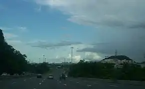
PR-22 (also part of unsigned Interstate PR2) is an 84.3 km (52.4 mi)[3] long toll road in the north coast of Puerto Rico that connects the cities of San Juan and Hatillo. The road is also known as the José de Diego Expressway (Spanish: Expreso José de Diego), and is part of unsigned Interstate PR-2. It is a 4-lane road for much of its length, but expands to up to 12 lanes in the San Juan metro area. The road is frequently congested, in particular during rush hour due to heavy commuter traffic.
| ||||
|---|---|---|---|---|
| Autopista José de Diego | ||||
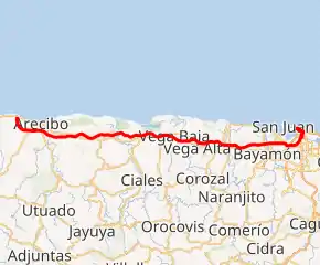
PR-22 highlighted in red | ||||
| Route information | ||||
| Maintained by Autopistas Metropolitanas de Puerto Rico | ||||
| Length | 84.3 km[1] (52.4 mi) | |||
| Existed | 1969[2]–present | |||
| Major junctions | ||||
| West end | ||||
| ||||
| East end | ||||
| Location | ||||
| Municipalities | Hatillo, Arecibo, Barceloneta, Manatí, Vega Baja, Vega Alta, Dorado, Toa Baja, Bayamón, Cataño, Guaynabo, San Juan | |||
| Highway system | ||||
| ||||


Route description
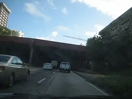
PR-22 is Puerto Rico's most traveled highway.[4] PR-22 runs parallel to PR-2 and is concurrent with unsigned Interstate Highway PRI-2. Unlike PR-22, PR-2 is not a controlled-access road, and has numerous traffic signals throughout the full run of its course. The construction of highway PR-22 reduced congestion on PR-2. The eastern terminus is at PR-26 (a non-tolled freeway) in Santurce, and passes through the Minillas Tunnel before its terminus at PR-26. The freeway bypasses all of the cities PR-2 passes through (see below under "Course of the Expressway"). PR-22's western terminus is at PR-2 in Hatillo. From there, PR-2 continues to Aguadilla and Mayagüez, ending in Ponce.
History
Construction of this road began in 1969. The section from San Juan to Toa Baja opened in 1969 and in 1997 to Arecibo.[5] Construction of the road was partially funded from appropriations of the U.S. Interstate Highway System.[6]
Future
PR-22 is planned to be extended to Aguadilla.[7] The extension will be built as part of a public–private partnership, who will maintain and operate PR-22 for the next 40 years.
Privatization
The Autopistas Metropolitanas de Puerto Rico consortium, comprised by Abertis Infraestructuras and Goldman Sachs Infrastructure Partners II LP, placed the winning bid for the 40-year PR-22 and PR-5 highway concession. The highways generate between $90 million and $95 million annually in toll revenue, which will now go to the private operators.[8]
Tolls
PR-22 is maintained by a system of tolls managed by the Puerto Rico Department of Transportation and Public Works.[9] All of its toll plazas have express lanes. After June 17, 2017, the seven tolls plaza of the PR-22 will become bidirectional.
| Location | Toll | Direction | AutoExpreso acceptance |
AutoExpreso replenishment (R) lane |
|---|---|---|---|---|
| Hatillo | $0.70 | Two-way | ||
| Arecibo Rampa | $0.70 | Two-way (ramp) | ||
| Arecibo | $1.00 | Two-way | ||
| Manatí | $1.00 | Two-way | ||
| Vega Alta | $0.70 | Two-way | ||
| Toa Baja | $0.70 | Two-way | ||
| Buchanan | $0.70 | Two-way |
Originally, PR-22 had only five toll plazas (Fort Buchanan, Toa Baja, Vega Alta, Factor ramp, and Hatillo); the Manatí and Arecibo toll plazas were added in the early 1990s.
The future segment from Hatillo to Aguadilla is expected to have four additional toll plazas;[10] however, it remains to be seen whether they will be one way or two way.
As of 2014–2015, plans are underway to implement Open road tolling (ORT) and currently on many stretches of PR-22; Cash is no longer accepted to pay tolls with the exception of replenishing the toll tag.
On June 17, 2017 the new two-way collection rates cames into effect by AutoExpreso in PR-22 and PR-5.
Exit list
| Municipality | Location | km[1] | mi | Exit | Destinations | Notes |
|---|---|---|---|---|---|---|
| Hatillo | Carrizales | 84.3 | 52.4 | 84B | Western terminus of PR-22. Splits into PR-2; Interstate PR2 continues westbound via PR-2 as an At-grade traffic light expressway. | |
| 83.5 | 51.9 | 84A | ||||
| 82.2 | 51.1 | Hatillo Toll Plaza | ||||
| Arecibo | Hato Abajo | 78.0– 77.9 | 48.5– 48.4 | 77 | Signed as exits 77A (north) and 77B (south) | |
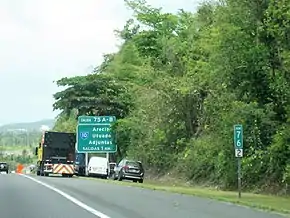
| Tanamá | 75.0– 74.9 | 46.6– 46.5 | 75 | Signed as exits 75A (north) and 75B (south) | ||
| Domingo Ruíz | 71.0 | 44.1 | 71 | Access to Antonio (Nery) Juarbe Pol Airport | ||
| Factor | 64.9 | 40.3 | 64 | ETC only; no AutoExpreso replenishment lane | ||
| 64.2 | 39.9 | Arecibo Toll Plaza (ETC only; no AutoExpreso replenishment lane) | ||||
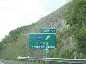
| Barceloneta | Florida Afuera | 56.9 | 35.4 | 57 | ||
| 55.1 | 34.2 | 55 | ||||
| Río Grande de Manatí | 55.1– 52.7 | 34.2– 32.7 | Puente Juan Ramírez Vélez | |||
| Manatí | Coto Norte | 47.7 | 29.6 | 48 | ||
| 46.4– 46.3 | 28.8– 28.8 | 46 | Westbound exit and eastbound entrance | |||
| 45.4 | 28.2 | Manatí Toll Plaza | ||||
| Vega Baja | Algarrobo | 41.7 | 25.9 | 42 | ||
| Pugnado Afuera | 38.0 | 23.6 | 38 | Avenida Trío Vegabajeño – Vega Baja | Westbound exit and eastbound entrance | |
| Río Indio | 37.1– 36.5 | 23.1– 22.7 | Puente Paso del Indio | |||
| Almirante Norte | 35.8 | 22.2 | 35 | |||
| Vega Alta | Bajura | 32.9 | 20.4 | 32 | ||
| Sabana | 31.9 | 19.8 | 31 | Westbound exit only; no re-entry | ||
| 31.4 | 19.5 | Vega Alta Toll Plaza | ||||
| Dorado | Higuillar | 27.5 | 17.1 | 27 | ||
| Maguayo | 23.8 | 14.8 | 24 | |||
| Toa Baja | Media Luna | 22.4– 22.3 | 13.9– 13.9 | 22 | Westbound exits are signed as 22A (north) and 22B (south). | |
| 21.8 | 13.5 | Toa Baja Toll Plaza | ||||
| Candelaria | 17.4 | 10.8 | 17 | |||
| Sabana Seca | 15.6 | 9.7 | 16 | |||
| Bayamón | Hato Tejas | 12.7 | 7.9 | 13 | Access to Bayamón station | |
| Bayamón–Cataño municipal line | Juan Sánchez–Palmas line | 10.9 | 6.8 | 11 | ||
| 10.1 | 6.3 | 10 | Only westbound direction. This is a new version (freeway version) of original access exit (Exit 9). | |||
| 9.7 | 6.0 | 9 | ||||
| Guaynabo | Pueblo Viejo | 8.0 | 5.0 | Buchanan Toll Plaza | ||
| 6.9 | 4.3 | 7 | Exits signed 7A and 7B | |||
| 5.6 | 3.5 | 6 | Signed as Exits 6A and 6B. In westbound direction there is an exit (Exit 5) to PR-2 northbound after Exit 2B. | |||
| San Juan | Gobernador Piñero | 4.6 | 2.9 | 5 | PR-2 northbound is accessible from PR-22 westbound, and PR-2 southbound is accessible from Exit 6. | |
| Hato Rey Norte | 3.0 | 1.9 | 3 | Avenida Roosevelt / Calle Calaf – Plaza Las Américas | Eastbound exit signed as 2B. | |
| 2.6 | 1.6 | 2A | ||||
| Santurce | 1.3– 1.2 | 0.81– 0.75 | 1 | Signed as Exits 1A and 1B. | ||
| 0.9– 0.4 | 0.56– 0.25 | 0 | Exits are signed as Exit 0A, Exit 0B, but Exit 0C in the tunnel are unsigned. These exits are only accessible in eastbound direction. Access to Pavía Santurce and Doctors' Center Hospital-San Juan. | |||
| 0.0 | 0.0 | — | Eastern terminus of Interstate PR2 and PR-22. Splits into PR-26 and Interstate PR3. PR-26 exit 2A | |||
1.000 mi = 1.609 km; 1.000 km = 0.621 mi
| ||||||
See also
- Interstate Highways in Puerto Rico
- List of highways numbered 22
References
- Google (27 February 2020). "PR-22" (Map). Google Maps. Google. Retrieved 27 February 2020.
- Historia. Departamento de Transportacion y Obras Publicas de Puerto Rico. Archived on 16 February 2009. Retrieved 10 August 2020.
- Guía de Carreteras Principales, Expresos y Autopistas. (In Spanish) Puerto Rico Autoridad de Carreteras y Transportacion (ACT).
- Puerto Rico Highways and Transportation Authority. Presentation by Rubén Hernández Gregorat, Executive Director, PRHTA. February 26, 2010. At the Puerto Rico Credit Conference 2010. February 23–24, 2010.
- Legends of Puerto Rico. Archived 2010-09-28 at the Wayback Machine
- U.S. Dept. of Transportation, Federal Highway Administration.FHWA Route Log and Finder List. Additional Designations. Retrieved on February 20, 2008.
- Goldman Sachs, Abertis close on 40 year $1,136m concession of Puerto Rico's PR22 & PR5 tollroads Archived 2011-10-16 at the Wayback Machine
- Abertis-Goldman Sachs group wins highways deal with $1.08 billion bid Archived 2012-03-24 at the Wayback Machine
- Puerto Rico Department of Transportation and Public Works
- DTOP
External links
 Media related to Puerto Rico Highway 22 at Wikimedia Commons
| Signed | |
|---|---|
| Unsigned | |
| Lists | |
| Other | |
Major Interstates highlighted | |