Punjgirain
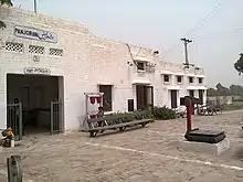
Panjgirain is a town of Darya Khan Tehsil, Bhakkar District, Punjab, Pakistan. It is also the headquarters of union council Punjgirain. It is located on Darya Khan Kalur Kot Road. There is a basic health unit (BHU) and Govt. High School for boys and girls here. A Panj Girain railway station is also on Multan Kundian railway track section.
Panjgirain
پنجگرائیں | |
|---|---|
Town | |
| Panjgirain | |
 Panjgirain Location in Pakistan | |
| Coordinates: 31°55′10″N 71°09′00″E | |
| Pakistan | |
| Province | Punjab |
| Government | |
| • UC Nazim | Qari Muhammad Ashrif |
| • UC Naib Naib Nazim | Ghulam Qasim Karkali |
| Elevation | 148 m (486 ft) |
| Time zone | UTC+5 (PST) |
| 30110 | 30100 |
| Number of Union councils | 1 |
| Website | http://www.bhakkar.com.pk |
JAMIA MASJID SADIQIA(AHALE SUNNAT) is the largest mosque of the town Jamia Naqvia Arabia is a great Shia islamic darsgah in Panjgirain. A police patrol check post is also here.Pir Haji Ahmed Sultan, Haji Shah and Imam's are main graveyards. wheat, sugarcane, chickpea, Mung bean, and cotton are corps produced here.
On the east of town the area is desert called Thal and west area is well cultivated near by Indus River called Nashaib. Main villages in the union council are Jhok Mehar Shah, Jhok Qalander Shah, Jhok Laal Shah, Basti Ahmad Shah wali Dager and Nashaib.