Thal Desert
The Thal desert (Urdu, Punjabi: صحراےَ تھل) is situated in Punjab, Pakistan. The vast expanse is located between the Jhelum and Sindh rivers near the Pothohar Plateau, with a total length from north to south 190 miles, and a maximum breadth of 70 miles (110 km) and minimum breadth 20 miles. The desert covers the districts of Bhakkar, Khushab, Mianwali, Layyah, Muzaffargarh as well as Jhang, from the left bank of the river Jhelum. Geographically, it resembles the deserts of Cholistan and Thar.
| Thal Desert | |
|---|---|
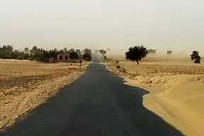 A road passing through Thal desert at Noorpur | |
| Length | 305 km (190 mi) |
| Geography | |
| Country | Pakistan |
The Greater Thal canal
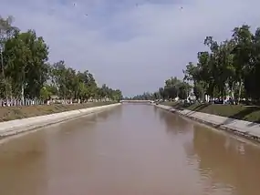
The history of the Thal Canal Project goes back to over 130 years. It was in 1873 that the project was first conceived for the whole of the Thal Doab. The proposal to irrigate this area with water from the Indus River[1] was repeatedly brought up for discussion in 1919, 1921, 1924, 1925, 1936 and in 1949. It was repeatedly shelved because of the argument that it would severely hurt the water availability to the lower riparians. The project proposal once again came under discussion in 1975 when the Executive Committee of the National Economic Council (ECNEC) refused to endorse the project. Finally, on August 16, 2001, Pakistani President Pervez Musharraf inaugurated the 30-billion-rupee Greater Thal Canal project (GTC).[2]The second phase of Greater Thal Canal Phase project (Choubara Branch) was launched in 2020. This will bring around 3 lakh acres of the desert land under irrigation.[3]
Culture and society
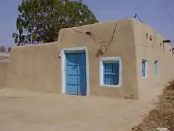
The Thalochi dialect is spoken in the district. The populations of the district are diffused over a large desert expanse, causing people to travel large distances, as well as to migrate to the central regions of Punjab for work.
See also
References
External links
 Media related to Thal Desert at Wikimedia Commons