Pura Island
Pura is an island in the Alor archipelago, located on the eastern tip of the Lesser Sunda Islands. The island is the largest island in the Pantar Strait, which separates the two larger islands of Pantar and Alor. It has an area of 27.83 km2, with a hilly terrain along the northern coast of the island.[1]
| Native name: Pulau Pura | |
|---|---|
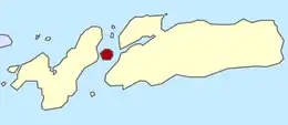 Location of Pura in Alor Regency | |
| Geography | |
| Coordinates | 8°18′15″S 124°20′31″E |
| Archipelago | Alor archipelago |
| Area | 27.83 km2 (10.75 sq mi) |
| Highest elevation | 1,015 m (3330 ft) |
| Highest point | Pura |
| Administration | |
| Province | East Nusa Tenggara |
| Regency | Alor |
| Subdistrict | Pura Island |
| Demographics | |
| Population | 5,459 (2019) |
| Pop. density | 196/km2 (508/sq mi) |
| Wikimedia Commons has media related to Pura Island. |
Administratively, the island consists the entirety of the Pura Island District (Kecamatan Pulau Pura), which in turn is further subdivided into 6 villages. Economically, the island remains dependent on agriculture and fishery which takes up 87% of the local workforce. Coconuts and cashew nuts take up the largest amount of cropland, while corn and cassava are the primary food crops, with some rice being cultivated as well. Of the 19 km of roads in the island, 18 are categorized as "heavily damaged" dirt roads.[1]
The island can be reached by motorboats from Alor, with the trip taking about 50 minutes. The highest point of the island, at 1,015 m, is the rim of a volcano cone.[2]
References
- "Pulau Pura dalam Angka 2017" (PDF) (in Indonesian). Alor Regency Statistics. Retrieved 2 October 2017.
- "Pura". Gunung Bagging. Retrieved 2 October 2017.