Alor Regency
Alor Regency (Indonesian: Kabupaten Alor) is a regency (kabupaten) in East Nusa Tenggara (NTT) province of Indonesia. Established in 1958,[2] Alor Regency administers the Alor Archipelago with its seat (capital) in Kalabahi on Alor Island.
Alor Regency
Kabupaten Alor | |
|---|---|
 Road in Maritaing | |
 Coat of arms | |
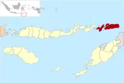 Location within East Nusa Tenggara | |
 Alor Regency Location in Lesser Sunda Islands and Indonesia  Alor Regency Alor Regency (Indonesia) | |
| Coordinates: 8.3°S 124.5°E | |
| Country | |
| Province | |
| Capital | Kalabahi |
| Government | |
| • Regent | Amon Djobo |
| • Vice Regent | Imran Duru |
| Area | |
| • Total | 1,130.85 sq mi (2,928.88 km2) |
| Population (2020 Estimate)[1] | |
| • Total | 206,806 |
| • Density | 180/sq mi (71/km2) |
| Time zone | UTC+8 (ICST) |
| Area code | (+62) 386 |
| Website | alorkab |
Alor Regency occupies 2,928.88 km² land area and 10,973.62 km² water area. There are seventeen islands in the archipelago, of which the largest by far are Alor itself and Pantar; there are another six inhabited islands (including Pura, Treweng, Kepa, Buaya, Kangge and Kura); the remaining nine islands (Sika, Nub, Kapas, Batang, Lapang, Ternate, Rusa, Tikus and Kambing) are uninhabited. To the east lies the island of (Atauro), part of the Republic of East Timor. The regency had 190,026 inhabitants at the 2010 decennial census; at the 2015 Census this had risen to 199,787[3] and the most recent official estimate (for mid 2020) is 206,806.[4]
The main transportation access in the regency is by means of sea. The state-owned PELNI sea liners operate in the archipelago for major transport to the main port hub in Kalabahi beside small boats operating between small islands. A small Perintis Mali airstrip (18 km east of Kalabahi) can only be used by small CASA airplanes, operated by Merpati Nusantara Airlines.
As is the case in other parts of NTT province, the provision of education is often a major problem, especially in remote areas. In recent years, the district (regency) government has been trying to make it easier for children to attend school by, amongst other things, increasing the number of one-roof junior high schools. The standard of teaching is often also a major problem because many teachers lack proper qualifications.[5]
Administration
The regency is divided into seventeen districts (kecamatan), tabulated below with their areas and their 2010 Census population[6] and the official estimates for mid-2019.[7] The table also includes the number of villages (rural desa and urban kelurahan) in each district, and its post code.
| Name | Area in km2 | Population Census 2010 | Population Estimate mid 2019 | Number of villages | Post codes |
|---|---|---|---|---|---|
| Pantar (a) | 119.82 | 8,798 | 9,519 | 11 | 85881 |
| Pantar Barat (b) (West Pantar) | 58.71 | 6,729 | 7,281 | 7 | 85880 |
| Pantar Timur (c) (East Pantar) | 141.44 | 10,740 | 11,621 | 11 | 85884 |
| Pantar Barat Laut (d) (Northwest Pantar) | 306.02 | 4,276 | 4,627 | 7 | 85882 |
| Pantar Tengah (Central Pantar) | 150.13 | 9,313 | 10,077 | 10 | 85883 |
| Pantar total island | 776.12 | 39,856 | 43,125 | 46 | |
| Alor Barat Daya (Southwest Alor) | 447.97 | 21,530 | 23,294 | 20 | 85861 |
| Mataru | 102.78 | 5,582 | 6,038 | 7 | 85860 |
| Alor Selatan (South Alor) | 192.97 | 8,886 | 9,614 | 14 | 85871 |
| Alor Timur (East Alor) | 562.76 | 7,505 | 8,120 | 10 | 85870 |
| Alor Timur Laut (Northeast Alor) | 208.49 | 8,600 | 9,305 | 8 | 85873 |
| Pureman | 147.88 | 3,471 | 3,755 | 4 | 85874 |
| Teluk Mutiara (e) (Mutiara Bay) | 80.18 | 48,410 | 52,375 | 16 | 85811 -85819 |
| Kabola (f) | 73.01 | 7,326 | 7,926 | 5 | 85819 (g) |
| Alor Barat Laut (h) (Northwest Alor) | 107.96 | 18,765 | 20,303 | 19 | 85851 |
| Alor Tengah Utara (North Central Alor) | 125.14 | 10,919 | 11,815 | 14 | 85870 |
| Lembur | 75.79 | 4,131 | 4,470 | 6 | 85875 |
| Alor total island | 2,124.93 | 145,125 | 157,015 | 123 | |
| Pulau Pura (Pura Island) | 27.83 | 5,045 | 5,459 | 6 | 85874 |
Notes: (a) includes just the northern part of Pantar Island. (b) includes offshore islands of Pulau Kura and uninhabited Batang and Lapang. (c) includes offshore Pulau Treweng. (d) includes offshore islands of Pulau Kangge and uninhabited Kambing, Rusa and Tikus. (e) containing the town of Kalabahi, plus uninhabited Pulau Kapas.
(f) includes the uninhabited offshore islands of Sika and Nub. (g) apart from villages of Alila Timur and Lawahing (which have a postcode of 85851. (h) includes the offshore islands of Pulau Kepa, Pulau Buaya and uninhabited Pulau Ternate.
References
- Badan Pusat Statistik, Jakarta, 2020.
- Government of Indonesia (9 August 1958), Establishment of the Second-level Administrative Regions under the First-level Administrative Region of Bali, West Nusa Tenggara and East Nusa Tenggara (in Indonesian ed.), Indonesia Ministry of Law and Justice, UU No. 69/1958, retrieved 2007-08-24
- Badan Pusat Statistik, Jakarta, 2018.
- Badan Pusat Statistik, Jakarta, 2020.
- Yennis Fointuna, 'Schooling: Alor govt strives to improve education', The Jakarta Post, 16 June 2012.
- Biro Pusat Statistik, Jakarta, 2011.
- Badan Pusat Statistik, Jakarta, 2020.
External links
- Official website
- Van Galen's memorandum on the Alor Islands
Regencies and cities of East Nusa Tenggara | ||
|---|---|---|
Capital: Kupang | ||
| Regencies |  | |
| Cities | ||