Lesser Sunda Islands
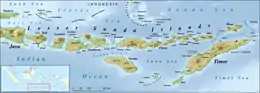
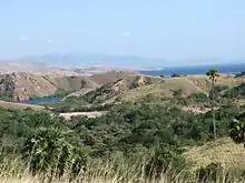
The Lesser Sunda Islands (Indonesian: Kepulauan Nusa Tenggara "southeastern archipelago"[1] or Kepulauan Sunda Kecil "lesser sunda archipelago"[2]) are an archipelago in Maritime Southeast Asia, north of Australia. Together with the Greater Sunda Islands to the west they make up the Sunda Islands. The islands are part of a volcanic arc, the Sunda Arc, formed by subduction along the Sunda Trench in the Java Sea.
| Native name: Kepulauan Nusa Tenggara Kepulauan Sunda Kecil | |
|---|---|
 | |
| Geography | |
| Location | Southeast Asia Southwestern Pacific |
| Coordinates | 9°00′S 120°00′E |
| Archipelago | Sunda Islands |
| Highest elevation | 3,726 m (12224 ft) |
| Administration | |
| Provinces | Bali West Nusa Tenggara East Nusa Tenggara Maluku (Barat Daya Islands and Tanimbar Islands only) |
| Municipalities | Oecusse Liquiçá Dili Manatuto Baucau Lautém Bobonaro Ermera Aileu Viqueque Cova Lima Ainaro Manufahi |
| Demographics | |
| Ethnic groups | Balinese, Sasak, Bimese, Atoni, Manggaraian, Sumbawan, Dompuan, Sumbese, Lamaholot, Tetum, Mambai, Kemak, Moluccans, Alfur, Javanese, Bugis |
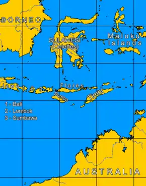
The main Lesser Sunda Islands are, from west to east: Bali, Lombok, Sumbawa, Flores, Sumba, Timor, Alor archipelago, Barat Daya Islands, and Tanimbar Islands.
Administration
The Lesser Sundas comprise many islands, most of which are part of Indonesia and are administered as the provinces of Bali, West Nusa Tenggara, East Nusa Tenggara and the southern part of Maluku.
The eastern half of Timor is the separate nation of East Timor.
Geology
The Lesser Sunda Islands consist of two geologically distinct archipelagos.[3] The northern archipelago, which includes Bali, Lombok, Sumbawa, Flores and Wetar, is volcanic in origin. A number of these volcanoes, like Mount Rinjani on Lombok, are still active while others, such as Ilikedeka on Flores, are extinct. The northern archipelago began to be formed during the Pliocene, about 15 million years ago, as a result of the collision between the Australian and the Asian plates.[3] The islands of the southern archipelago, including Sumba, Timor and Babar, are non-volcanic and appear to belong to the Australian plate.[4] The geology and ecology of the northern archipelago share similar history, characteristics, and processes with the southern Maluku Islands, which continue the same island arc to the east.
There is a long history of geological study of these regions since Indonesian colonial times; however, the geological formation and progression is not fully understood, and theories of the geological evolution of the islands changed extensively during the last decades of the 20th century.[5]
Lying at the collision of two tectonic plates, the Lesser Sunda Islands comprise some of the most geologically complex and active regions in the world.[5]
There are a number of volcanoes located on the Lesser Sunda Islands.[6]
Ecology
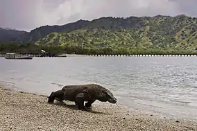
The Lesser Sunda Islands differ from the large islands of Java or Sumatra in consisting of many small islands, sometimes divided by deep oceanic trenches. Movement of flora and fauna between islands is limited, leading to the evolution of a high rate of localized species, most famously the Komodo dragon.[5] As described by Alfred Wallace in The Malay Archipelago, the Wallace Line passes between Bali and Lombok, along the deep waters of the Lombok Strait which formed a water barrier even when lower sea levels linked the now-separated islands and landmasses on either side. The islands east of the Lombok Strait are part of Wallacea, and are thus characterised by a blend of wildlife of Asian and Australasian origin in this region.[7] Asian species predominate in the Lesser Sundas: Weber's Line, which marks the boundary between the parts of Wallacea with mainly Asian and Australasian species respectively, runs to the east of the group. These islands have the driest climate in Indonesia, and tropical dry broadleaf forests are predominant, in contrast to the tropical moist forests that prevail in most of Indonesia.
Ecoregions
The Lesser Sunda Islands are divided among six ecoregions:[8]
- The Eastern Java-Bali rain forests and Eastern Java-Bali montane rain forests cover Bali, which is the only of the Lesser Sunda Islands in the Indomalayan realm, and not part of Wallacea. Bali was once attached to the Asian continent (see Sundaland), and home to large Asiatic mammals like Asian elephants and the extinct Bali tiger.
- The Lesser Sundas deciduous forests include the northern chain of islands, from Lombok and Sumbawa east to Flores and Alor. The higher slopes of the islands contain forests of tall Podocarpus conifers and Engelhardias with an undergrowth of lianas, epiphytes, and orchids such as Corybas, Corymborkis, and Malaxis (adder's mouth), while the coastal plains were originally savanna grasses such as the savanna with Borassus flabellifer palm trees on the coasts of Komodo, Rincah and Flores. Although most of the vegetation on these islands is dry forest there are patches of rainforest on these islands too, especially in lowland areas and riverbanks on Komodo, and there is a particular area of dry thorny forest on the southeast coast of Lombok. Thorn trees used to be more common in coastal areas of the islands but have largely been cleared. These islands are home to unique species including seventeen endemic birds (of the 273 birds found on the islands). The endemic mammals are the endangered Flores shrew (Suncus mertensi), the vulnerable Komodo rat (Komodomys rintjanus), and Lombok flying fox (Pteropus lombocensis), Sunda long-eared bat (Nyctophilus heran) while the carnivorous Komodo dragon, which at three metres long and ninety kilograms in weight is the world's largest lizard, is found on Komodo, Rincah, Gili Motang, and the coast of northwestern Flores.
- The Sumba deciduous forests ecoregion includes Sumba.
- The Timor and Wetar deciduous forests ecoregion includes Timor, Wetar, Rote, and Savu.
- The more humid Banda Sea Islands moist deciduous forests ecoregion includes the Barat Daya Islands (except for Wetar), the Tanimbar Islands, and the Kai Islands.
Threats and preservation
More than half of the original vegetation of the islands has been cleared for planting of rice and other crops, for settlement and by consequent forest fires. Only Sumbawa now contains a large area of intact natural forest, while Komodo, Rincah and Padar are now protected as Komodo National Park.
While many ecological problems affect both small islands and large landmasses, small islands suffer their particular problems and are highly exposed to external forces. Development pressures on small islands are increasing, although their effects are not always anticipated. Although Indonesia is richly endowed with natural resources, the resources of the small islands of Nusa Tenggara are limited and specialised; furthermore human resources in particular are limited.[9]
General observations[10] about small islands that can be applied to Nusa Tenggara include:[9]
- A higher proportion of the landmass will be affected by volcanic activity, earthquakes, landslips, and cyclone damage;
- Climates are more likely to be maritime influenced;
- Catchment areas are smaller and degree of erosion higher;
- A higher proportion of the landmass is made up of coastal areas;
- A higher degree of environmental specialisation, including a higher proportion of endemic species in an overall Depauperate community;
- Societies may retain a strong sense of culture having developed in relative isolation;
- Small island populations are more likely to be affected by economic migration.
See also
- Apostolic Vicariate of Lesser Sunda Islands (originally an Apostolic Prefecture)
- Banda Arc
- Greater Sunda Islands
- Islands of Indonesia
- List of rivers of Lesser Sunda Islands
- Oceanic trench
- Plate tectonic
- Sunda Arc
- Sundaland
- Sunda Shelf
- Sunda Trench
Notes
- Bijdragen tot de taal-, land- en volkenkunde / Journal of the Humanities and Social Sciences of Southeast Asia. Brill Publishers. 2011. ISBN 9789790644175. Archived from the original on 4 March 2016.
- "Badak Sunda dan Harimau Sunda". "[...] Mr. M. Yamin yang pada 1950-an ketika menjadi Menteri P.P. dan K. mengganti istilah Kepulauan Sunda Kecil menjadi Kepulauan Nusa Tenggara. Sebab, istilah Kepulauan Sunda Kecil diganti dengan Kepulauan Nusa Tenggara, maka istilah Kepulauan Sunda Besar juga tidak lagi digunakan dalam ilmu bumi dan perpetaan nasional Indonesia – meskipun dalam perpetaan Internasional istilah Greater Sunda Islands dan Lesser Sunda Islands masih tetap digunakan." - Ajip Rosidi: Penulis, budayawan. Pikiran Rakyat, 21 August 2010. Archived from the original on 8 July 2015. Retrieved 7 July 2015.
- Audley-Charles, M.G. (1987) "Dispersal of Gondwanaland: relevance to evolution of the Angiosperms" In: Whitmore, T.C. (ed.) (1987) Biogeographical Evolution of the Malay Archipelago Oxford Monographs on Biogeography 4, Clarendon Press, Oxford, pp. 5–25, ISBN 0-19-854185-6
- Veevers, J.J. (1991) "Phanerozoic Australia in the changing configuration of ProtoPangea through Gondwanaland and Pangea to the present dispersed continents" Australian Systematic Botany 4: pp. 1–11
- Monk, K.A.; Fretes, Y.; Reksodiharjo-Lilley, G. (1996). The Ecology of Nusa Tenggara and Maluku. Hong Kong: Periplus Editions Ltd. p. 9. ISBN 962-593-076-0.
- "Volcanoes of Indonesia: Lesser Sunda Islands". Global Volcanism Program. Smithsonian National Museum of Natural History. Retrieved 1 January 2013.
- Monk (1996), page 4
- Wikramanayake, Eric; Eric Dinerstein; Colby J. Loucks; et al. (2002). Terrestrial Ecoregions of the Indo-Pacific: a Conservation Assessment. Washington, DC: Island Press
- Monk (1996), page 1
- Beller, W., P. d'Ayala, and P. Hein. 1990. Sustainable development and environmental management of small islands. Paris and New Jersey: United Nations Educational, Scientific, and Cultural Organisation and Parthenon Publishing Group Inc.; Hess, A, 1990. Overview: sustainable development and environmental management of small islands. In Sustainable development and environmental management of small islands. eds W. Beller, P. d'Ayala, and P. Hein, Paris and New Jersey: United Nations Educational, Scientific, and Cultural Organisation and Parthenon Publishing Group Inc. (both cited in Monk)
References
- Monk, K.A.; Fretes, Y.; Reksodiharjo-Lilley, G. (1996). The Ecology of Nusa Tenggara and Maluku. Hong Kong: Periplus Editions Ltd. ISBN 962-593-076-0.
External links
 Lesser Sunda Islands travel guide from Wikivoyage
- LexiRumah (part of the Lesser Sunda linguistic databases)
- Reconstructing the past through languages of the present: the Lesser Sunda Islands
| Authority control |
|---|