Purbba Gopalpur
Purbba Gopalpur is a village in the Panskua CD block in the Tamluk subdivision of the Purba Medinipur district in the state of West Bengal, India.
Purbba Gopalpur | |
|---|---|
Village | |
 Purbba Gopalpur Location in West Bengal, India  Purbba Gopalpur Purbba Gopalpur (India) | |
| Coordinates: 22.4345°N 87.7472°E | |
| Country | |
| State | West Bengal |
| District | Purba Medinipur |
| Population (2011) | |
| • Total | 1,110 |
| Languages | |
| • Official | Bengali, English |
| Time zone | UTC+5:30 (IST) |
| PIN | 721139 |
| Telephone/STD code | 03228 |
| Lok Sabha constituency | Ghatal |
| Vidhan Sabha constituency | Panskura Paschim |
| Website | purbamedinipur |
Geography
| Cities and towns in Tamluk subdivision of Purba Medinipur district M: municipal city/ town, CT: census town, R: rural/ urban centre, H: historical/ religious centre Owing to space constraints in the small map, the actual locations in a larger map may vary slightly |
Location
Purbba Gopalpur is located at 22.4345°N 87.7472°E.
Urbanisation
94.08% of the population of Tamluk subdivision live in the rural areas. Only 5.92% of the population live in the urban areas, and that is the second lowest proportion of urban population amongst the four subdivisions in Purba Medinipur district, just above Egra subdivision.[1]
Note: The map alongside presents some of the notable locations in the subdivision. All places marked in the map are linked in the larger full screen map.
Demographics
According to the 2011 Census of India, Purbba Gopalpur had a total population of 1,110, of which 574 (52%) were males and 536 (49%) were females. There were 101 persons in the age range of 0–6 years. The total number of literate persons in Purbba Goplapur was 849 (89.14% of the population over 6 years).[2]
Purbba Gopalpur picture gallery
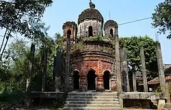 Pancharatna Radha Gobinda temple
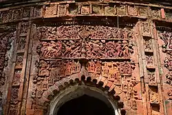 Terracotta decoration
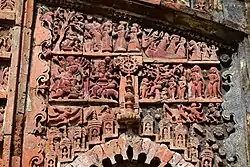 Terracotta decoration
The pictures are a part of Wiki Explores Purba Medinipur programme, an initiative by West Bengal Wikimedians User Group
References
- "District Statistical Handbook 2014 Purba Medinipur". Table 2.2. Department of Planning and Statistics, Government of West Bengal. Archived from the original on 21 January 2019. Retrieved 20 April 2019.
- "CD block Wise Primary Census Abstract Data(PCA)". West Bengal – District-wise CD blocks. Registrar General and Census, India. Retrieved 16 August 2020.
| Wikimedia Commons has media related to Purba Gopalpur, Panskura CD block. |
Cities, towns, locations and neighbourhoods in Purba Medinipur District | |||||||||
|---|---|---|---|---|---|---|---|---|---|
| Cities, municipal and census towns |
| ||||||||
| Locations other than cities and towns |
| ||||||||
| Neighbourhoods |
| ||||||||
| Related topics |
| ||||||||