Mahishadal
Mahishadal is a small town in Mahishadal CD block in Haldia subdivision of Purba Medinipur district in the state of West Bengal, India.
Mahishadal
Garh kamalpur | |
|---|---|
Village | |
 Mahishadal Rajbari | |
 Mahishadal Location in West Bengal, India  Mahishadal Mahishadal (India) | |
| Coordinates: 22°11′00.0″N 87°59′00.0″E | |
| Country | |
| State | West Bengal |
| District | Purba Medinipur |
| Languages | |
| • Official | Bengali, English |
| Time zone | UTC+5:30 (IST) |
| PIN | 721628 (Rangibasan) |
| Telephone/STD code | 03224 |
| Lok Sabha constituency | Tamluk |
| Vidhan Sabha constituency | Mahisadal |
| Website | purbamedinipur |
Eminent personalities
- Satish Chandra Samanta – Indian independence movement activist.[1]
- Suryakant Tripathi 'Nirala' – one of the most significant poets of modern Hindi literature. He went to school at Mahishadal.[1]
Geography
| Cities and towns in Haldia subdivision of Purba Medinipur district M: municipal city/ town, CT: census town, R: rural/ urban centre, S: port Owing to space constraints in the small map, the actual locations in a larger map may vary slightly |
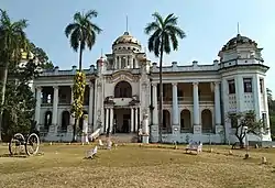
Mahishadal Rajbari
A businessman from north India, Janardhan Upadhyay Garg, developed a large estate in the 16th century. During the days of Rani Janaki Devi, it reached its zenith in the 18th century.[2] There are two palaces – the old one was built in 1840 and the new one in 1935. One can see stuffed animals, hunting weapons of the 16th and 17th century, paintings and furniture. Gopaljew and Ramjew temples are popular with tourists. The place is half an hours drive from Haldia.[3]
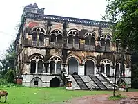 Mahishadal's old rajbari
Police station
Mahishadal police station has jurisdiction over Mahishadal CD block. Mahishadal police station covers an area of 135 km2 with a population of 182,365. The police station is located at Garh Kamalpur mouza.[4][5]
CD block HQ
The headquarters of Mahishadal CD block are located at Rangibasan.[6]
Urbanisation
79.19% of the population of Haldia subdivision live in the rural areas. Only 20.81% of the population live in the urban areas, and that is the highest proportion of urban population amongst the four subdivisions in Purba Medinipur district.[7]
Note: The map above presents some of the notable locations in the subdivision. All places marked in the map are linked in the larger full screen map.
Demographics
As per the map of Mahishadal CD block and subsequent alphabetical list of villages in the District Census Handbook, Purba Medinipur, Mahishadal is a part of Rangibasan village.[8]
As per 2011 Census of India Rangibasan had a total population of 2,570 of which 1,321 (51%) were males and 1,249 (49%) were females. Population below 6 years was 231. The total number of literates in Rangibasan was 2,134 (91.24% of the population over 6 years).[9]
Transport
The Mecheda-Tamluk-Haldia Road passes through Mahishadal.[10]
| ||||||||||||||||||||||||||||||||||||||||||||||||||||||||||||||||||||||||||||||||||||||||||||||||||||||||||||||||||||||||||||||||||||||||||||||||||||||||||||||||||||||||||||||||||||||||||||||||||||||||||||||||||||||||||||||||||||||||||||||||||||||||||||||||||||||||||||||||||||||||||||||||||||||||||||||||||||||||||||||||||||||||||||||||||||||||||||||||||||||||||||||||||||||||||||||||||||||||||||||||||||||||||||||||||||||||||||||||||||||||||||||||||||||||||||||||||||||||||||||||||||||||||||||||||||||||||||||||||||||||||||||||||||||||||||||||||||||||||||||||||||||||||||||||||||||||||||||||||||||||||||||||||||||||||
| Sources:[11][12][13][14] | ||||||||||||||||||||||||||||||||||||||||||||||||||||||||||||||||||||||||||||||||||||||||||||||||||||||||||||||||||||||||||||||||||||||||||||||||||||||||||||||||||||||||||||||||||||||||||||||||||||||||||||||||||||||||||||||||||||||||||||||||||||||||||||||||||||||||||||||||||||||||||||||||||||||||||||||||||||||||||||||||||||||||||||||||||||||||||||||||||||||||||||||||||||||||||||||||||||||||||||||||||||||||||||||||||||||||||||||||||||||||||||||||||||||||||||||||||||||||||||||||||||||||||||||||||||||||||||||||||||||||||||||||||||||||||||||||||||||||||||||||||||||||||||||||||||||||||||||||||||||||||||||||||||||||||
Mahishadal railway station and Satish Samanta Halt railway station are railway stations on the Panskura-Haldia line.[15]
Education
Mahishadal Raj College was established at Garh Kamalpur in 1946. A coeducational institution, it is affiliated to Vidyasagar University. It offers courses in arts, science and commerce.[16][1]
Mahishadal Girls College was established in 1969 with the initiative of Dr. Satyendranath Bhuniya, Rabindranath Singha, Dr. Haridas Sarkar, Gopal Chandra Mondal and others. Affiliated to Vidyasagar University, it offers courses in arts and science.[17][18]
Culture
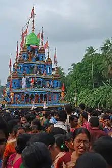
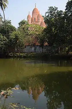
David J. McCutchion mentions the Madan Gopala temple as a West Bengal nava-ratna, plain and renovated, measuring about 39’ square.[19]
Healthcare
Basulia Rural Hospital located at nearby Basulia (with 30 beds) is the main medical facility in Mahishadal CD block. There are primary health centres at Natsal, PO Geonkhali (with 10 beds) and Rajarampur, PO Geonkhali (with ? beds).[20]
References
- "Mahishadal Raj College". College Admission. Retrieved 10 November 2016.
- "Mahishadal: A lesser known historical footprint in West Bengal". India Trope. Retrieved 10 November 2016.
- "Surrounding areas". Haldia Tourism and Industrial Development. Retrieved 10 November 2016.
- "District Statistical Handbook 2014 Purba Medinipur". Tables 2.1, 2.2. Department of Statistics and Programme Implementation, Government of West Bengal. Archived from the original on 29 July 2017. Retrieved 10 November 2016.
- "Mahishdal PS". Purba Medinipur District Police. Retrieved 10 November 2016.
- "District Census Handbook: Purba Medinipur" (PDF). Map of Purba Medinipur with CD Block HQs and Police Stations. Directorate of Census Operations, West Bengal, 2011. Retrieved 10 November 2016.
- "District Statistical Handbook 2014 Purba Medinipur". Table 2.2. Department of Planning and Statistics, Government of West Bengal. Retrieved 21 April 2019.
- "District Census Handbook, Purba Medinipur, Series 20, Part XIIA, Census of India, 2011" (PDF). Map on Page 333. Directorate of Census Operations, West Bengal. Retrieved 28 March 2019.
- "2011 Census – Primary Census Abstract Data Tables". West Bengal – District-wise. Registrar General and Census Commissioner, India. Retrieved 10 November 2016.
- Google maps
- Google Maps
- Kharagpur-Howrah Local 38606 Indiarailinfo
- Howrah-Haldia Local 68689 ⇒ 38089 Indiarailinfo
- Santragachi-Digha EMU 78001 ⇒ 68687 Indiarailinfo
- "38089 Howrah-Haldia Local". Time Table. indiarailinfo. Retrieved 10 November 2016.
- "Mahishadal Raj College". collegebatch.com. Retrieved 9 April 2019.
- "Mahishadal Girls' College". Mahishadal Girls’ College. Retrieved 10 November 2016.
- "Mahishadal Girls' College". College Admission. Retrieved 10 November 2016.
- McCutchion, David J., Late Mediaeval Temples of Bengal, first published 1972, reprinted 2017, page 52. The Asiatic Society, Kolkata, ISBN 978-93-81574-65-2
- "Health & Fam ily Welfare Department". Health Statistics. Government of West Bengal. Retrieved 27 March 2019.
External links
 Geonkhali travel guide from Wikivoyage – information about Mahishadal is included.
| Wikimedia Commons has media related to Mahishadal. |
Cities, towns, locations and neighbourhoods in Purba Medinipur District | |||||||||
|---|---|---|---|---|---|---|---|---|---|
| Cities, municipal and census towns |
| ||||||||
| Locations other than cities and towns |
| ||||||||
| Neighbourhoods |
| ||||||||
| Related topics |
| ||||||||