Auburn, Washington
Auburn is a city in King County, Washington, United States (with a small portion crossing into neighboring Pierce County). The population was 70,180 at the 2010 United States Census.[6] Auburn is a suburb in the Seattle metropolitan area, and is currently ranked as the fifteenth largest city in the state of Washington.
Auburn | |
|---|---|
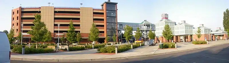
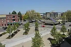 Downtown Auburn in 2018, seen from the train station's parking garage | |
Flag | |
| Nickname(s): A-town | |
| Motto(s): "More Than You Imagined" | |
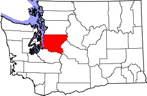
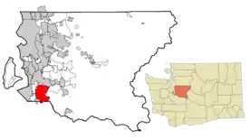 Location of Auburn in King County | |
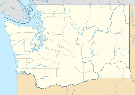 Auburn Location in Washington  Auburn Auburn (the United States)  Auburn Auburn (North America) | |
| Coordinates: 47°18′8″N 122°12′53″W | |
| Country | United States |
| State | Washington |
| Counties | King, Pierce |
| Founded | June 13, 1891 |
| Government | |
| • Type | Mayor–council |
| • Mayor | Nancy Backus |
| Area | |
| • Total | 29.87 sq mi (77.35 km2) |
| • Land | 29.58 sq mi (76.60 km2) |
| • Water | 0.29 sq mi (0.75 km2) |
| Elevation | 82.62 ft (25 m) |
| Population | |
| • Total | 70,180 |
| • Estimate (2019)[3] | 81,464 |
| • Rank | US: 420th WA: 15th |
| • Density | 2,754.30/sq mi (1,063.45/km2) |
| [4] | |
| Time zone | UTC−8 (PST) |
| • Summer (DST) | UTC−7 (PDT) |
| ZIP codes | 98001, 98002, 98092, 98071 |
| Area code(s) | 253 |
| FIPS code | 53-03180 |
| GNIS feature ID | 1511974[5] |
| Website | auburnwa.gov |
Auburn is bordered by the cities of Federal Way, Pacific, and Algona to the west, Sumner to the south, Kent to the north, and unincorporated King County to the east. The Muckleshoot Indian Reservation is in or near the southern city limits.[7]
History
Before the first non-indigenous settlers arrived in the Green River Valley in the 1850s, the area was home to the Muckleshoot people, who were temporarily driven out by Indian wars later that decade. Several settler families arrived in the 1860s, including Levi Ballard, who set up a homestead between the Green and White rivers.[8] Ballard filed for a plat to establish a town in February 1886, naming it Slaughter for an officer slain during the Indian wars in 1855.[9][10]
Slaughter was incorporated on June 13, 1891, but its name was changed two years later to Auburn on February 21, 1893, by an action of the state legislature. Newer residents had disliked the name and its connection to the word "slaughter", especially after the town's hotel was named the Slaughter House.[9][10] The name Auburn was chosen in honor of Auburn, New York, for the area's shared reliance on hops farming.[11]
The White and Green Rivers have been a major part of the history and culture of Auburn since the area was settled with multiple locations in the city being named after either of the two rivers. Frequent flooding from the rivers caused numerous problems for the people living in the community with one outcome being the creation of Mountain View Cemetery over on one of the hills overlooking the valley.[12] It was not until the completion of the Mud Mountain Dam and the Howard A. Hanson Dam, along the White River and Green River respectively, that the flooding would cease and allow the city to grow without the aforementioned hurdle impeding the growth.
In 1917 the city, in response to the growing of the Japanese community, donated some of the land in Pioneer Cemetery to the White River Buddhist Church. A little over ten years later, Rev. Giryo Takemura, minister of the church at the time, and his future son-in-law, Chiyokichi Natsuhara, raised money to replace the old wooden sticks and columns that had been in use as gravestones at the Cemetery with more durable concrete markers.[13] The interwar period saw several Japanese-American baseball teams from the area compete in the courier league with the White River All-Stars enjoying particularly large success winning four of the July 4th tournaments.[14][15] In 1930 a Japanese bath house was constructed outside of Neely Mansion by the then current tenants.[16]
The onset of the Second World War saw the Japanese-American community of Auburn become seen with largely unwarranted distrust by many of the white residents of Auburn. This, combined with a larger countrywide Japanese focused xenophobia, led to the city's Japanese-American population being relocated to internment camps. After the war, of about 300 Japanese families living in Auburn only around twenty five returned.[13]
In 2008, Auburn annexed the West Hill and Lea Hill neighborhoods of unincorporated King County, adding 15,000 residents and expanding its land area by 26 percent.[17][18]
Geography and climate
Auburn is located at 47°18′8″N 122°12′53″W (47.302322, −122.214779).[19]
According to the United States Census Bureau, the city has a total area of 29.89 square miles (77.41 km2), of which, 29.62 square miles (76.72 km2) is land and 0.27 square miles (0.70 km2) is water.[20]
Two rivers, the White River and, to a greater extent, the Green River flow through Auburn.
Historically, the Stuck River ran through the settlement of Stuck, which is now a small pocket of unincorporated King County within southern Auburn. In 1906, the flow of the White River was diverted into the Stuck's channel near today's Game Farm Park.[21] References to the Stuck River still appear in some property legal descriptions and place names, e.g. Stuck River Drive, within Auburn, but today it is essentially indistinguishable from the southern White River.[22]
| Climate data for Auburn, Washington | |||||||||||||
|---|---|---|---|---|---|---|---|---|---|---|---|---|---|
| Month | Jan | Feb | Mar | Apr | May | Jun | Jul | Aug | Sep | Oct | Nov | Dec | Year |
| Record high °F (°C) | 64 (18) |
71 (22) |
81 (27) |
86 (30) |
92 (33) |
100 (38) |
99 (37) |
99 (37) |
96 (36) |
86 (30) |
74 (23) |
69 (21) |
100 (38) |
| Average high °F (°C) | 47 (8) |
51 (11) |
55 (13) |
61 (16) |
67 (19) |
72 (22) |
77 (25) |
78 (26) |
72 (22) |
62 (17) |
52 (11) |
46 (8) |
62 (17) |
| Average low °F (°C) | 35 (2) |
36 (2) |
39 (4) |
42 (6) |
47 (8) |
52 (11) |
55 (13) |
55 (13) |
51 (11) |
44 (7) |
39 (4) |
35 (2) |
44 (7) |
| Record low °F (°C) | −10 (−23) |
−5 (−21) |
10 (−12) |
25 (−4) |
27 (−3) |
33 (1) |
38 (3) |
34 (1) |
28 (−2) |
24 (−4) |
−1 (−18) |
3 (−16) |
−10 (−23) |
| Average precipitation inches (mm) | 5.3 (130) |
4.5 (110) |
4.1 (100) |
2.9 (74) |
2.1 (53) |
1.7 (43) |
0.9 (23) |
1.2 (30) |
1.8 (46) |
3.4 (86) |
6.1 (150) |
5.8 (150) |
37.1 (940) |
| Source: Weather.com[23] | |||||||||||||
Parks
Auburn has an extensive system of parks, open space and urban trails consisting of 28 developed parks, over 23 mi (37 km) of trails (including Auburn's 4.5 mi (7.2 km) portion of the Interurban Trail for bikers, walkers, runners and skaters), and almost 247 acres (100 ha) of open space for passive and active recreation.
Transportation
Auburn has many large roads nearby and within city limits, including State Route 167 (commonly referred as the "Valley Freeway") and State Route 18. Auburn also has its own transit center, Auburn station in downtown, that serves as a major hub for southern King County. Sound Transit buses connect the Auburn Transit Center directly to Federal Way, Sumner, and Kent, while King County Metro buses connect it to Green River Community College, the Super Mall, and Auburn Way.
Sounder commuter trains travel from Auburn to Downtown Seattle in approximately 30 minutes, and to Lakewood station in less than 35 minutes.
Until 1987, Auburn was home to a steam locomotive roundhouse and diesel engine house of the Northern Pacific Railway, the BNSF Railway of today. BNSF maintains a rail yard and small car repair facility, along with maintenance-of-way facilities at the former NP yard.[24] The Auburn Municipal Airport serves the general aviation community.[25]
Demographics
| Historical population | |||
|---|---|---|---|
| Census | Pop. | %± | |
| 1890 | 740 | — | |
| 1900 | 489 | −33.9% | |
| 1910 | 957 | 95.7% | |
| 1920 | 3,163 | 230.5% | |
| 1930 | 3,906 | 23.5% | |
| 1940 | 4,211 | 7.8% | |
| 1950 | 6,497 | 54.3% | |
| 1960 | 11,933 | 83.7% | |
| 1970 | 21,653 | 81.5% | |
| 1980 | 26,417 | 22.0% | |
| 1990 | 33,102 | 25.3% | |
| 2000 | 40,314 | 21.8% | |
| 2010 | 70,180 | 74.1% | |
| 2019 (est.) | 81,464 | [3] | 16.1% |
2010 census
As of the census[2] of 2010, there were 70,180 people, 26,058 households, and 17,114 families residing in the city. The population density was 2,369.3 inhabitants per square mile (914.8/km2). There were 27,834 housing units at an average density of 939.7 per square mile (362.8/km2). The racial makeup of the city was 70.5% White, 4.9% African American, 2.3% Native American, 8.9% Asian, 1.6% Pacific Islander, 6.3% from other races, and 5.4% from two or more races. Hispanic or Latino people of any race were 12.9% of the population.
There were 26,058 households, of which 36.2% had children under the age of 18 living with them, 46.7% were married couples living together, 13.0% had a female householder with no husband present, 5.9% had a male householder with no wife present, and 34.3% were non-families. 25.6% of all households were made up of individuals, and 7.9% had someone living alone who was 65 years of age or older. The average household size was 2.67 and the average family size was 3.22.
The median age in the city was 34.4 years. 25.9% of residents were under the age of 18; 10.5% were between the ages of 18 and 24; 27.9% were from 25 to 44; 25.5% were from 45 to 64; and 10.2% were 65 years of age or older. The gender makeup of the city was 49.4% male and 50.6% female.
2000 census
As of the census of 2000, there were 40,314 people, 16,108 households, and 10,051 families residing in the city. The population density was 1,895.9 per square mile (732.1/km2). There were 16,767 housing units at an average density of 788.5 per square mile (304.5/km2). The racial makeup of the city was 82.80 percent White, 2.42 percent African American, 2.54 percent Native American, 3.50 percent Asian, 0.51 percent Pacific Islander, 3.66 percent from other races, and 4.56 percent from two or more races. Hispanic or Latino people of any race were 7.49 percent of the population.
There were 16,108 households, out of which 32.8 percent had children under the age of eighteen living with them, 43.7 percent were married couples living together, 13.4 percent had a female householder with no husband present, and 37.6 percent were non-families. 29.1 percent of all households were made up of individuals, and 9.1 percent had someone living alone who was 65 years of age or older. The average household size was 2.47 and the average family size was 3.05.
In the city the population was spread out, with 26.6 percent under the age of eighteen, 9.5 percent from eighteen to 24, 31.6 percent from 25 to 44, 20.7 percent from 45 to 64, and 11.6 percent who were 65 years of age or older. The median age was 34 years. For every 100 females, there were 98.5 males. For every 100 females age 18 and over, there were 95.5 males.
The median income for a household in the city was $39,208, and the median income for a family was $45,426. Males had a median income of $36,977 versus $27,476 for females. The per capita income for the city was $19,630. About 10.2 percent of families and 12.8 percent of the population were below the poverty line, including 15.3 percent of those under age 18 and 8.8 percent of those age 65 or over.
Neighborhoods
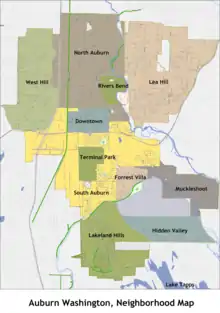
- Downtown—Historic buildings with a Main Street USA appearance, also many Craftsman-style houses from the 1920s.
- North Auburn—A mix of commercial and single-family housing separated by Auburn Way North.
- River's Bend—A small residential neighborhood nestled along the Green River, located at the bottom of Lea Hill in North Auburn.
- Christopher/Thomas—An area in North Auburn roughly bordered by the Valley Drive Inn and 227th Street. Both are former farming towns annexed into the city in the 1960s.
- Lea Hill—A mainly residential neighborhood east of the valley, annexed into the city in 2007. Green River Community College is located here.
- Hazelwood—The area on Lea Hill between Green River Community College, and Auburn Mountainview High School. Once a town in the late nineteenth century.
- West Valley—A commercial and industrial area on the west side of SR 167, located on the bottom of West Hill.
- West Hill—Located on the West Hill, bordered by the city of Federal Way to the west.
- South Auburn—A general area located south of downtown, once a low-income area but becoming a commercial zone.
- Terminal Park—An area of middle class housing near the end of the rail yard named for the railroad workers who lived there.
- Forest Villa—Mainly residential area located in the Game Farm Park area.
- Lakeland Hills—A master-planned community sprawling on a large hillside at the southern end of the city on both sides of King and Pierce counties.
- Hidden Valley—A planned development located East of Lakeland Hills overlooking North Lake Tapps.
- Muckleshoot Area—The general area of the Muckleshoot Indian Reservation.
Government
| Year | Republican | Democratic | Third Parties |
|---|---|---|---|
| 2020 | 39.00% 14,092 | 57.90% 20,919 | 3.10% 1,121 |
The city of Auburn is a mayor-council form of government meaning the mayor is a full-time, separately elected position. The current Mayor is Nancy Backus, who was first elected to the post in 2013 and re-elected in 2017. She is the first female to serve in the office since Auburn was incorporated in 1891.
Auburn is the site for the Northwest headquarters of United States General Services Administration.
Auburn is designated by the Veterans Day National Committee and the US Department of Veterans Affairs as a Regional Site for celebration of Veterans Day.
Auburn Police Department
Annexation
Using King County's Annexation Initiative, Auburn annexed Lea Hill and West Hill in 2008. With the annexation, the city grew in population from 40,314 to 68,000 and increased its land area from 21.26 square miles (55.06 km2) to 29.89 square miles (77.41 km2).[28][29]
Crime
According to the Uniform Crime Report statistics compiled by the Federal Bureau of Investigation (FBI) in 2017, there were 376 violent crimes and 3,618 property crimes per 100,000 residents. Of these, the violent crimes consisted of three murders, 64 forcible rapes, 117 robberies and 192 aggravated assaults, while 732 burglaries, 2,124 larceny-thefts, 653 motor vehicle thefts and 19 acts of arson defined the property offenses.[30]
Economy
Jobs
As of 2017 there are 60,118 jobs in Auburn and a 4.1% unemployment rate.[31]
The Auburn Boeing Plant, opened in 1966, is the largest airplane parts plant in the world, with 2,100,000 square feet (200,000 m2) and 1.265 million parts being manufactured each year.[32] With over 5,000 employees, the Boeing plant is the third major employer in Auburn.
According to Auburn's 2011 Comprehensive Annual Financial Report,[33] the top employers in the city are:
| # | Employer | # of employees |
|---|---|---|
| 1 | Boeing | 5,993 |
| 2 | The Outlet Collection Seattle | 3,208 |
| 3 | Auburn School District | 2,410 |
| 4 | Muckleshoot Tribal Enterprises | 1,650 |
| 5 | Auburn Medical Center | 1,580 |
| 6 | Green River Community College | 1,315 |
| 7 | Emerald Downs | 1,162 |
| 8 | Safeway | 870 |
| 9 | Social Security Administration | 660 |
| 10 | Zones, Inc. | 644 |
| 10 | Certainteed Corporation | – |
| 10 | City of Auburn | – |
Recreation and entertainment
Auburn has an extensive system of parks, open space and urban trails: 28 developed parks, over 23 mi (37 km) of trails (including Auburn's 4.5 mi (7.2 km) portion of the Inter-urban Trail for bikers, walkers, runners and skaters), and almost 247 acres (100 ha) of open space for passive and active recreation.
The Outlet Collection Seattle, formerly SuperMall of the Great Northwest, is an outlet mall which opened in 1995.
Emerald Downs is a 167-acre (0.68 km2) six-level stadium and thoroughbred racetrack. The racetrack is operated on land purchased by the Muckleshoot in 2002.
The White River Valley Museum's exhibits feature Auburn, from Native American history to the 1920s. They focus on the Muckleshoot Indian Tribe, pioneer life, immigration from Europe and Japan, truck farming, railroading and the building of towns throughout the area. Visitors can visit a recreation of a pioneer cabin, climb aboard a Northern Pacific Railway caboose, and investigate a recreation of the shops in 1924 downtown Auburn.[34]
The White River Amphitheater is a 20,000-seat venue, located about 3 miles (4.8 kilometers) east of the city limits.
Notable people
- Harrison Maurus, bronze medal Weightlifting athlete[35]
- Nate Cohn, journalist and polling expert for The Upshot at The New York Times
- Janna Crawford, gold medal Paralympic athlete
- Cam Gigandet, actor[36]
- Christine Gregoire, 22nd Governor of Washington[37]
- Kevin Hagen, former MLB baseball player[38]
- Greg Haugen, professional boxer[39]
- Gordon Hirabayashi, civil rights activist[40]
- Ariana Kukors, Olympic swimmer and world record holder
- Chris Lukezic, middle-distance runner[41]
- Evan McMullin, CIA officer and former presidential candidate[42]
- Sir Mix-A-Lot, hip hop artist[43]
- Blair Rasmussen, NBA basketball player[44]
- Dave Reichert, former King County Sheriff and U.S. Congressman[45]
- Diane Schuur, jazz singer and pianist[46]
- Francis R. "Dick" Scobee, NASA astronaut[47]
- Danny Shelton, NFL football player[48]
- D. C. Simpson, comic artist[49]
- Misty Upham, actress
- Minoru Yamasaki, architect[50]
Education
Currently the Auburn School District has 15 elementary schools, four middle schools and three high schools, making 22 schools in all.[51] The district is larger than the city itself, serving the neighboring towns of Algona and Pacific, as well as some unincorporated areas around Auburn and Kent.
Green River College also resides in Auburn, atop Lea Hill.
High schools
ASD has three primary high schools:[52]
| School | Location | Mascot | Colors | Approx. students |
|---|---|---|---|---|
| Auburn High School | Auburn | Trojan | Green, gold | 1,693 |
| Auburn Riverside High School | Auburn | Raven | Navy, teal, silver | 1,639 |
| Auburn Mountainview High School | Auburn | Lion | Blue, orange | 1,515 |
Private and alternative high schools
| School | Location | Mascot | Colors | Approx. students |
|---|---|---|---|---|
| West Auburn Secondary High School | Auburn | Wolf | Silver, black | 275 |
| Auburn Adventist Academy | Auburn | Falcon | Blue, gold | 310 |
| Rainier Christian High School | Auburn | Mustang | Blue, silver | 130 |
Middle schools 6–8
- Cascade Middle School[53] is located in North Auburn, and has a student population of 750. Its mission statement is "Spartan Excellence: Everyone, Everyday, Everywhere." The school's mascot is the Spartan.
- Mt. Baker Middle School[54] is located in the southwest region of Auburn. It has about 1,000 students.
- Olympic Middle School[55] is located in South Auburn and has about 700 students. It is currently being rebuilt.
- Rainier Middle School[56] is on Lea Hill and has about 1000 students. The school's mascot is the panther.
Elementary schools K-5
- Alpac Elementary School[57] is located in Pacific, Washington . It was opened in 1973 and named for the cities of Algona and Pacific. Originally an open classroom concept school, it converted to standard classroom ideals in 1983.
- Arthur Jacobsen Elementary School[58] opened in 2007, on the former Jacobsen Tree farm and on the lower portion of Auburn Mountainview's campus. It is the youngest school in the district.
- Chinook Elementary School[59] opened in 1963 and was named for the nearby White River Fish Hatchery. It is located on the Muckleshoot Indian Reservation.
- Dick Scobee Elementary School[60] opened in 1959 as North Auburn Elementary and was renamed for the astronaut and Auburn High School graduate who died as commander of the Space Shuttle Challenger.
- Evergreen Heights Elementary School[61] opened in 1970, located on the West Hill of Auburn.
- Gildo Rey Elementary School[62] opened in 1969 under the name of South Auburn Elementary. It was renamed in 1976 in honor of longtime faculty member Gildo Rey.
- Rainier Christian Schools – Kent View [63] in Auburn opened on September 1, 2005 after buying the property from Thomas Academy. The campus also houses Little People Pre-School.
- Hazelwood Elementary School[64] opened in 1990 on Auburn's Lea Hill.
- Ilalko Elementary School[65] opened in 1992. It is named after a Native American village; "Ilalko" means "striped water."
- Lakeland Hills Elementary School,[66] Auburn's largest elementary school, opened in the Lakeland Hills community in 2006. It outperformed the state and district in the new SBA assessment and MSP Science Assessment.[67]
- Lake View Elementary School[68] opened in 1980.
- Lea Hill Elementary School[69] opened in 1965 as one of only 11 schools in the United States designated as a National Educational landmark by the National Park Service.
- Pioneer Elementary School[70] opened in 1950.
- Terminal Park Elementary School[71] opened in 1945. It was named for the terminal end of the railroad and the neighborhood where the rail workers lived, Terminal Park.
- Washington Elementary School[72] is the oldest elementary school in Auburn. It is located next to Auburn High School. It originally opened in 1920, and was demolished and re-built in 1970.
City landmarks
The City of Auburn has designated the following landmarks:
| Landmark | Built | Listed | Address | Photo |
|---|---|---|---|---|
| Auburn Masonic Temple[73] | 1923–24 | 2002 | 302–310 E. Main Street | 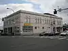 |
| Auburn Post Office[73] | 1937 | 2000 | 20 Auburn Avenue NE | 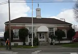 |
| Auburn Public Library[73] | 1914 | 1995 | 306 Auburn Avenue NE | 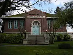 |
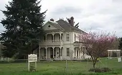
| Olson Farm[73] | 1897–1902 | 1995, 2000 | 28728 Green River Road S |
Image gallery
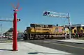 A Union Pacific train passing downtown
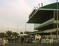 Emerald Downs seating
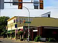 The old JC Penney's building, downtown
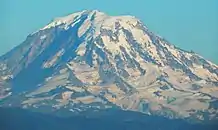
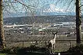 A view from Centennial Viewpoint Park, looking towards Mt. Rainier and the Valley floor
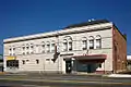 Masonic Temple in Auburn
 Former Auburn Post Office
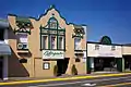 Lifegate Auburn Foursquare Church
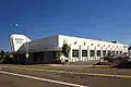 Auburn Justice Center
Sister cities
Auburn has five sister cities: ![]() Tamba, Japan
Tamba, Japan
The relationship with Tamba is commemorated with an annual student exchange program between the two cities and neighboring Kent.[74]
References
- "2019 U.S. Gazetteer Files". United States Census Bureau. Retrieved August 7, 2020.
- "U.S. Census website". United States Census Bureau. Retrieved December 19, 2012.
- "Annual Estimates of the Resident Population for Incorporated Places in Washington: April 1, 2010 to July 1, 2019". United States Census Bureau. May 2020. Retrieved May 27, 2020.
- "2010 Census Redistricting Data (Public Law 94-171) Summary File". American FactFinder. United States Census Bureau. Retrieved February 24, 2013.
- "Auburn". Geographic Names Information System. United States Geological Survey.
- "ANNEXATION". Archived from the original on October 9, 2008. Retrieved February 24, 2013.
- "Muckleshoot Area Vicinity Map". muckleshoot.nsn. Muckleshoot Tribe. Retrieved January 6, 2015.
- "The town formerly known as Slaughter". Maple Valley Reporter. July 5, 2017. Retrieved March 31, 2019.
- Stein, Alan J. (January 8, 1999). "Auburn — Thumbnail History". HistoryLink. Retrieved March 31, 2019.
- "Auburn, Washington, United States". Encyclopaedia Britannica. Retrieved March 31, 2019.
- Wilma, David (October 17, 1999). "Slaughter is renamed Auburn on February 21, 1893". HistoryLink. Retrieved February 24, 2013.
- "Mountain View Cemetery History - City of Auburn". Retrieved March 8, 2020.
- "About the Auburn Pioneer Cemetery, Auburn, Washington". Retrieved March 8, 2020.
- "White River All-Stars Baseball Team - May 1935". Retrieved March 8, 2020.
- Mullan, Michael (1999). "Ethnicity and Sport: The Wapato Nippons and Pre-World War II Japanese American Baseball". Journal of Sport History. 26 (1): 97–100. JSTOR 43611719.
- "Japanese Bathhouse Neely Mansion Association". Retrieved March 8, 2020.
- Archbold, Mike (January 18, 2007). "Auburn might grow much larger". The News Tribune. p. B1. Archived from the original on January 23, 2007. Retrieved March 31, 2019.
- Archbold, Mike (December 2, 2007). "Stakes high for Auburn in area census". The News Tribune. p. B1.
- "US Gazetteer files: 2010, 2000, and 1990". United States Census Bureau. February 12, 2011. Retrieved April 23, 2011.
- "US Gazetteer files 2010". United States Census Bureau. Archived from the original on January 12, 2012. Retrieved December 19, 2012.
- "White River Valley Museum". Wrvmuseum.org. Archived from the original on June 24, 2009. Retrieved May 2, 2010.
- http://www5.metrokc.gov/reports/property_report.asp?PIN=6655000025%5B%5D
- "Monthly Averages for Seattle, WA". The Weather Channel. Archived from the original on November 6, 2007. Retrieved September 28, 2007.
- "Northern Santa Fe central roundhouse". Content-dev.lib.washington.edu. Archived from the original on July 8, 2012. Retrieved May 2, 2010.
- "Welcome to S50 Auburn Municipal Airport near Seattle and Tacoma Washington (WA)". S50wa.com. Retrieved May 2, 2010.
- "Census of Population and Housing". Census.gov. Retrieved June 4, 2016.
- King County Elections
- "King County Annexation Initiative Auburn Lea Hill and Auburn West Hill". Retrieved February 24, 2013.
- "Community Profile". Archived from the original on July 11, 2012. Retrieved February 24, 2013.
- "WASHINGTON - Offenses Known to Law Enforcement by City, 2017". Federal Bureau of Investigation. 2017. Retrieved October 5, 2018.
- "2017 Comprehensive Annual Financial Report".
- "Boeing Frontiers Online Source". Retrieved February 24, 2013.
- "2015 Comprehensive Annual Financial Report".
- "White River Valley Museum website". Wrvmuseum.org. Retrieved May 2, 2010.
- https://auburnexaminer.com/harrison-maurus-badass-with-a-barbell/
- "Cam Gigandet". IMDb. Retrieved February 26, 2019.
- "About Chris". Governor.wa.gov. Archived from the original on February 24, 2011. Retrieved September 12, 2013.
- Raley, Dan; Reporter, P.-I. (May 31, 2006). "Where Are They Now? Ex-pitcher Kevin Hagen". seattlepi.com. Retrieved February 26, 2019.
- Klaas, Mark (April 7, 2010). "Auburn's young Haugen vows to fight for own identity". Auburn Reporter. Retrieved March 3, 2019.
- "Gordon Hirabayashi portrait in the "Invader" 1935 Auburn High School Yearbook". cdm16786.contentdm.oclc.org. Retrieved February 26, 2019.
- "Chris Lukezic". www.usatf.org. Retrieved February 26, 2019.
- Haglund, David (February 2, 2017). "Evan McMullin Is Trying to Save Democracy". The New Yorker. ISSN 0028-792X. Retrieved February 26, 2019.
- "Sir Mix-A-Lot | Encyclopedia.com". www.encyclopedia.com. Retrieved March 3, 2019.
- "NBA Players: Blair Rasmussen Profile and Basic Stats". www.landofbasketball.com. Retrieved February 26, 2019.
- Carlton Smith and Thomas Guillen, The Search For The Green River Killer (New York: Onyx, 1991), 7–12
- Feather, Leonard (April 27, 1986). "Diane Schuur Riding a Sure Thing". The Los Angeles Times. p. 64.
- "Astronaut Bio: Dick Scobee". NASA.
- Skager, Shawn (December 18, 2013). "Danny Shelton is finding the fun again". Auburn Reporter. Retrieved February 26, 2019.
- "Q&A: Cartoonist grew up in Gig Harbor, lives in Auburn and likes unicorns". The News Tribune. Retrieved March 3, 2019.
- Olson, Casey (September 7, 2011). "Towering achievement: WTC one of Auburn man's monumental designs". Auburn Reporter. Retrieved February 26, 2019.
- "About Us / Overview". www.auburn.wednet.edu. Retrieved May 20, 2017.
- "About Us". Auburn School District. Retrieved January 4, 2015.
- Cascade Middle School
- Mt. Baker Middle School
- Olympic Middle School
- Rainier Middle School
- Alpac Elementary School
- Arthur Jacobsen Elementary School
- Chinook Elementary School
- Dick Scobee Elementary School
- Evergreen Heights Elementary School
- Gildo Rey Elementary School
- Rainier Christian Schools – Kent View
- Hazelwood Elementary School
- Ilalko Elementary School
- Lakeland Hills Elementary School
- "Archived copy" (PDF). Archived from the original (PDF) on February 17, 2018. Retrieved February 16, 2018.CS1 maint: archived copy as title (link)
- Lake View Elementary School
- Lea Hill Elementary School
- Pioneer Elementary School
- Terminal Park Elementary School
- Washington Elementary School
- "King County and Local Landmarks List". December 29, 2015. Archived from the original on April 9, 2016.
- "Sister City Program". auburnwa.gov. City of Auburn. Archived from the original on August 27, 2015. Retrieved July 28, 2015.
External links
| Wikimedia Commons has media related to Auburn, Washington. |
Places adjacent to Auburn, Washington | |
|---|---|
Municipalities and communities of King County, Washington, United States | ||
|---|---|---|
| Cities |
|  King County map |
| Towns | ||
| CDPs |
| |
| Unincorporated communities | ||
| Indian reservation | ||
| Ghost towns | ||
| Footnotes | ‡This populated place also has portions in an adjacent county or counties | |
| ||
Municipalities and communities of Pierce County, Washington, United States | ||
|---|---|---|
| Cities |  Map of Washington highlighting Pierce County | |
| Towns | ||
| CDPs |
| |
| Other unincorporated communities | ||
| Indian reservation | ||
| Military bases | ||
| Ghost towns | ||
| Footnotes | ‡This populated place also has portions in an adjacent county or counties | |
| ||
| Authority control |
|---|