Ra Island
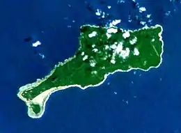
Rah or Ra is a small coral islet of 0.5 km2 (0.19 sq mi), located in the Banks group of northern Vanuatu.[2] The same name also refers to the single village which is situated within this islet. There are massive rocks on the island.[3]
| Native name: Aya | |
|---|---|
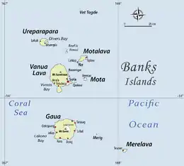
 The islet of Rah is located at the southwest point of the bigger island Mota Lava. | |
 | |
| Geography | |
| Location | Pacific Ocean |
| Coordinates | 13°42′58″S 167°37′48″E |
| Archipelago | Vanuatu, Banks Islands |
| Area | 0.5[1] km2 (0.19 sq mi) |
| Administration | |
Vanuatu | |
| Province | Torba Province |
| Demographics | |
| Population | 189 (2009) |
The islet of Rah is situated off the larger island of Mota Lava. Access to Rah is done in two ways: at low tide, by wading across the narrow strait from the mainland; at high tide, by outrigger canoe.
Name
The islet is known in English, and Bislama, as Rah [ra]. This name reflects a shortened version of the form Rao (IPA: [rao]), which is the way the islet is called in the neighbouring language Mota. The island is also referred to as Ara
In the islanders' own language Mwotlap, the islet of Rah is called Aya (IPA: [aˈja]).
The letter h in the English spelling Rah does not represent anything in the actual name.
Population
The 2009 census figures[4] give a population of 189 inhabitants. A 2015 estimate puts the population of the island at 224 people, with 42 households.[5]
References
- "Vanuatu". Haos Blong Volkeno. Retrieved 8 August 2018.
- "Mota Lava and Ra, escape to the Banks Islands". Positive Earth. Retrieved 5 August 2018.
- "Torba Province". Vanuate Travel. Retrieved 5 August 2018.
- "2009 National Census of Population and Housing: Summary Release" (PDF). Vanuatu National Statistics Office. 2009. Retrieved November 21, 2010.
- Vanuatu National Statistics Office. (17–18 March 2015). "2015 Vanuatu National Population and Households Projections by Province and islands". Retrieved 12 October 2020.
