Ambrym
Ambrym is a volcanic island in Malampa Province in the archipelago of Vanuatu. Volcanic activity on the island includes lava lakes in two craters near the summit.
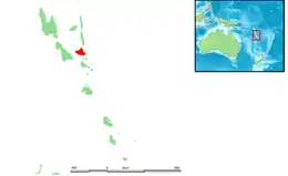 Map of Ambrym | |
| Geography | |
|---|---|
| Location | Pacific Ocean |
| Coordinates | 16°15′S 168°7′E |
| Archipelago | New Hebrides |
| Area | 677.7 km2 (261.7 sq mi) |
| Highest elevation | 1,334 m (4377 ft) |
| Administration | |
Vanuatu | |
| Province | Malampa |
| Demographics | |
| Population | 7,275 (2009) |
| Ethnic groups | Ni-Vanuatu |
| Ambrym | |
|---|---|
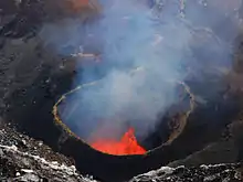 Lava lake in Marum crater, Ambrym, in a photo taken 24 September 2009 | |
| Highest point | |
| Elevation | 1,334 m (4,377 ft) [1] |
| Geography | |
| Location | Vanuatu |
| Geology | |
| Mountain type | Pyroclastic shield[1] |
| Volcanic arc | New Hebrides arc[1] |
| Last eruption | 2009 to 2018[2] |
Etymology
Ambrym (also known as Ambrin,[3] "ham rim" in the Ranon language)[4] was allegedly named by Captain Cook, who is said to have anchored off there in 1774. In fact, his expedition never touched Ambrym.
Geography
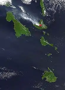
Located near the center of the Vanuatuan archipelago, Ambrym is roughly triangular in shape, about 50 km (31 mi) wide.[5] With 677.7 square kilometres (261.7 sq mi) of surface area, it is the fifth largest island in the country.
The summit at the centre of the island is dominated by a desert-like caldera, which covers an area of 100 square kilometres (39 sq mi).[1] With the exception of human settlements, the rest of the island is covered by a dense jungle.[5]
Volcanology
Ambrym is a large basaltic volcano with a 12-km-wide caldera, and is one of the most active volcanoes of the New Hebrides volcanic arc. The caldera is the result of a huge Plinian eruption, which took place around AD 50. Its explosive force is rated 6, the third highest in the Smithsonian Institution's Volcanic Explosivity Index ranks of the largest volcanic explosions in recent geological history.[6]
While at higher elevations cinder cones predominate, the western tip of the island is characterized by a series of basaltic tuff rings, of which the largest is about 1 kilometre (0.62 mi) in diameter. These were produced by phreatic eruptions when magma contacted the water table and water-saturated sediments along the coast.[7] The massive, 1900-year-old, 12 kilometres (7.5 mi) × 8 kilometres (5.0 mi) caldera is the site of two active volcanic cones, Benbow and Marum (also spelled Maroum).[1] Mount Benbow was named after English Admiral John Benbow (1653–1702) by Captain Cook.
Several times a century, Ambrym volcano has destructive eruptions. Mount Benbow last erupted explosively in 1913, causing the evacuation of the population to Mele, near Port Vila on Efate. Volcanic gas emissions from this volcano are measured by a Multi-Component Gas Analyzer System, which detects pre-eruptive degassing of rising magmas, improving prediction of volcanic activity.[8]
In March 2017, Google added Marum crater with its lava lakes to Google Streetview.[9] Since the last fissure eruption on 16 Dec 2018, the lava lake has disappeared.[10]
Demographics
With the neighbouring island of Malakula and a few smaller islands, Ambrym forms Malampa Province. The population of 7,275 inhabitants [11] lives mainly off coconut plantations in the three corners of the island.
Languages
Like many islands in Vanuatu, Ambrym has its own Austronesian languages. In the north is the North Ambrym language, in the southeast is the Southeast Ambrym language, in the south Daakaka language, in the west Lonwolwol language, and in the southwest Port Vato language. These are all spoken by a few hundred to a few thousand speakers each.
Towns and villages
Southwest
- Fali, Craig Cove, Baiap, Sesivi, Port Vato, Bwele, Lalinda, Tow, Yaotilie, Sanesup, Emiotungan, Maranata and Pelibetakever
Southeast
- Maat, Paamal, Toak, Uléi, Utas, Tavéak, Asé, Pawé, Saméo, Endu, Pahakol and Benebo
North
- Ranuetlam, Ranon, Olal, Fanla, Linboul, Wilit, Lonwara, Fona, Nebul and Megham
Tourism
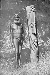
Tourists are attracted by Ambrym's active volcanoes, tropical vegetation, and the customs of the local villagers. They stay in traditional bungalows, as there are no hotels on the island.[4]
Transportation
The island is served by two airports, Ulei Airport in the southeast and Craig Cove Airport in the southwest.
Popular culture
Ambrym is featured in the 2016 Werner Herzog documentary, Into the Inferno.
References
- "Ambrym". Global Volcanism Program. Smithsonian Institution.
- "Ambrym volcano". 19 Feb 2018.
- "Ambrim: Vanuatu, name, geographic coordinates and map". Geographical Names. Retrieved 2011-07-29.
- "Ambrim". Destination Vanuatu, South Pacific. Retrieved 2011-07-29.
- "Ambrym Volcano, Vanuatu". John Seach. Retrieved 2011-07-29.
- "Large Volcano Explocivity Index". geographic.org. Archived from the original on 24 July 2011. Retrieved 2011-07-29.
- "Ambrym Volcano, Vanuatu". Countries of the World. geographic.org. Retrieved 2011-07-29.
- "Real-Time Multi-GAS sensing of volcanic gas composition: experiences from the permanent Etna and Stromboli networks, Geophysical Research Abstracts, Vol. 11, EGU2009-5839" (PDF).
- "Journey under the Earth's surface in Street View". Google Streetview. March 15, 2017.
- "Global Volcanism Program | Ambrym". Smithsonian Institution | Global Volcanism Program.
- 2009 National Census of Population and Housing, Vanuatu National Statistics Office
External links
- "West Ambrym". Documentation of Endangered Languages (DOBES). Max Planck Institute (MPI).
- Hosni, Soraya (2011). "Wer_spricht_noch_Daakaka" [Who still speaks Daakaka?] (Video blog). Science Movies. Project (in German). Center for General Linguistics Berlin (ZAS): Humboldt University of Berlin.
- Parker, G.J (1970). "South-East Ambrym word list". Austronesian Basic Vocabulary Database. University of Auckland. Archived from the original on 2013-06-05. Retrieved 2007-11-22.
- "Climbing A Volcanic Crater [Marum Volcano]" (Video). Educated Earth. Sep 20, 2010.
| Authority control |
|
|---|