Raam (West Papua)
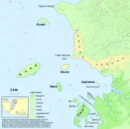
Raam, also spelt Ram, is an island in West Papua, Indonesia, located off the northwestern tip of the Bird's Head Peninsula of New Guinea. It lies at a distance of about 2 kilometres (1.2 mi) from the coast of the city of Sorong, and about 5 kilometres (3.1 mi) north of the islands of Doom and Soop (or Tsiof). About 1.6 kilometres (0.99 mi) long and up to 0.5 kilometres (0.31 mi) wide, Raam has an area of 0.5 square kilometres (0.19 sq mi). Occupying the eastern half of the island is a settlement with a population of 1,570 (as of 2016), which forms a kelurahan within the district of Kepulauan Sorong in the City of Sorong.
| Ram, Buaya | |
|---|---|
 Raam is in the north of the group of islands off Sorong. | |
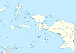
 Raam Location in eastern Indonesia | |
| Geography | |
| Coordinates | 0.838°S 131.214°E |
| Area | 0.52 km2 (0.20 sq mi) |
| Length | 1.6 km (0.99 mi) |
| Coastline | 4 km (2.5 mi) |
| Highest elevation | 65 m (213 ft) |
| Administration | |
| Province | West Papua |
| City | Sorong |
| District | Kepulauan Sorong |
| Demographics | |
| Population | 1,567 (2016) |
Bibliography
- Atlas peta potensi pengembangan komoditas dan kawasan perkebunan kakao dan pala provinsi Papua Barat (PDF). 2015. p. 55.
- Badan Pusat Statistik (BPS) Kabupaten Kota Sorong. Distrik Sorong Kepulauan Dalam Angka 2017 (Report). p. 34.
- Penutupan Lahan 2011 (available at WebGIS Kehutanan), a land cover dataset
- Sailing directions (enroute) : New Guinea (PDF). National Geospatial-intelligence Agency. 2018. p. 112.
This article is issued from Wikipedia. The text is licensed under Creative Commons - Attribution - Sharealike. Additional terms may apply for the media files.
