Sorong
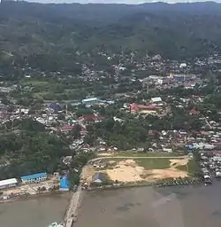
Sorong is the largest city of the Indonesian province of West Papua. The city is located on the western tip of the island of New Guinea with its only land borders being with Sorong Regency. It is the gateway to Indonesia's Raja Ampat Islands, species rich coral reef islands in an area considered the heart of the world's coral reef biodiversity.[1] It also is the logistics hub for Indonesia's thriving eastern oil and gas frontier. Sorong has experienced exponential growth since 2010, and further growth is anticipated as Sorong becomes linked by road to other frontier towns in Papua's Bird's Head Peninsula. The city had a population of 190,625 at the 2010 Census; the latest official estimate (as at mid 2019) is 254,294.[2] It is served by Domine Eduard Osok Airport.[3]
Sorong | |
|---|---|
| City of Sorong Kota Sorong | |
 | |
Coat of arms | |
| Motto(s): Setara – Bersahabat – Dinamis (Equal — Friendly — Dynamic) | |
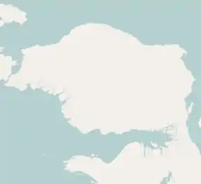 Sorong 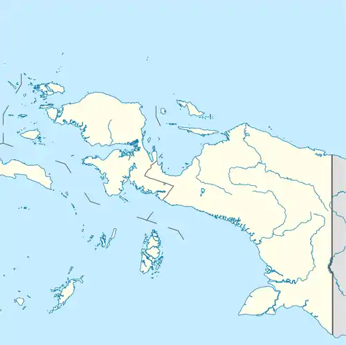 Sorong Sorong (Western New Guinea)  Sorong Sorong (Indonesia) | |
| Coordinates: 0°52′S 131°15′E | |
| Country | |
| Province | |
| Government | |
| • Mayor | Lambert Jitmau |
| • Vice Mayor | Pahimah Iskandar |
| Area | |
| • City | 1,105.0 km2 (426.6 sq mi) |
| Population (2019) | |
| • City | 254,294 |
| • Density | 230/km2 (600/sq mi) |
| • Metro | 345,342 |
| Time zone | UTC+9 (Indonesia Eastern Time) |
| Postcodes | 98414 |
| Area code | (+62) 951 |
| Website | sorongkota |
Etymology
The origin of Sorong's name comes from the word Soren, which means "deep and wavy ocean" in the Biak language. The name was first used by the Biak-Numfor people who sailed to different islands before they finally decided to settle down in Raja Ampat Islands. When the Biak-Numfor people came to the place called "Daratan Maladum", they decided to call it Soren. After centuries of contact with Chinese merchants, European missionaries, and people from Maluku and Sangihe-Talaud, the name underwent further change into Sorong.[4]
Administrative Districts
At the 2010 Census, the city comprised six districts (distrik), but the number has subsequently been increased to ten by the splitting of existing districts. These are tabulated below with their populations at the 2010 Census,[5] together with the latest estimates for mid-2019.[6] The table also includes the number of administrative villages (desa and kelurahan, 41 in total) in each district and its post code.
| Distrik | Area in km2 (2019) | Population 2010 Census | Population mid 2019 Estimate | Number of villages | Post code |
|---|---|---|---|---|---|
| Sorong Barat (West Sorong) | 127.74 | 35,306 | 33,950 | 4 | 98412 |
| Sorong Kepulauan (a) (Sorong Islands) | 200.11 | 9,711 | 11,887 | 4 | 98413 |
| Sorong Timur (East Sorong) | 69.39 | 26,804 | 26,663 | 4 | 98418 |
| Sorong Utara (North Sorong) | 127.21 | 45,001 | 30,685 | 4 | 98410 |
| Sorong (distrik) | 48.81 | 31,264 | 21,246 | 4 | 98416 |
| Sorong Manoi | 135.97 | 42,539 | 56,375 | 5 | 98415 |
| Maladu Mes | 126.40 | (b) | 8,424 | 4 | 98411 |
| Klaurung | 88.83 | (b) | 9,724 | 4 | 98417 |
| Malaimsimsa | 102.50 | (b) | 33,002 | 4 | 98419 |
| Sorong Kota (Sorong town) | 78.04 | (b) | 22,338 | 4 | 98414 |
| Totals | 1,105.00 | 190,625 | 254,294 | 41 |
Note: (a) Sorong Kepulauan district includes 25 offshore islands within the city limits, including Doom, Soop, Raam and Umbre Islands.
(b) the populations as at 2010 of the four new districts established after 2010 are included in the figures for the districts from which they were split off.
Climate
Sorong experiences the tropical rainforest climate (Af), as there is no real dry season throughout the year. The wettest month is June, with a total precipitation of 373 millimetres (14.7 in), while the driest month is February, with a total precipitation of 180 millimetres (7.1 in). The excessive precipitation is caused by the monsoon. The temperature variation remains constant throughout the year. The temperature difference between the hottest month and the coolest month is 1.2 °C (2.2 °F). The hottest month is November, with an average temperature of 27.8 °C (82.0 °F), while the coolest month is July, with an average temperature of 26.6 °C (79.9 °F).
| Climate data for Sorong, West Papua | |||||||||||||
|---|---|---|---|---|---|---|---|---|---|---|---|---|---|
| Month | Jan | Feb | Mar | Apr | May | Jun | Jul | Aug | Sep | Oct | Nov | Dec | Year |
| Average high °C (°F) | 30.6 (87.1) |
30.5 (86.9) |
30.5 (86.9) |
30.7 (87.3) |
30.6 (87.1) |
30.0 (86.0) |
29.4 (84.9) |
29.5 (85.1) |
29.9 (85.8) |
30.7 (87.3) |
31.0 (87.8) |
30.8 (87.4) |
30.4 (86.7) |
| Daily mean °C (°F) | 27.5 (81.5) |
27.4 (81.3) |
27.5 (81.5) |
27.6 (81.7) |
27.5 (81.5) |
27.1 (80.8) |
26.6 (79.9) |
26.7 (80.1) |
26.9 (80.4) |
27.5 (81.5) |
27.8 (82.0) |
27.6 (81.7) |
27.3 (81.1) |
| Average low °C (°F) | 24.4 (75.9) |
24.4 (75.9) |
24.6 (76.3) |
24.5 (76.1) |
24.5 (76.1) |
24.3 (75.7) |
23.9 (75.0) |
23.9 (75.0) |
24.0 (75.2) |
24.3 (75.7) |
24.6 (76.3) |
24.5 (76.1) |
24.3 (75.7) |
| Average precipitation mm (inches) | 194 (7.6) |
180 (7.1) |
198 (7.8) |
243 (9.6) |
368 (14.5) |
373 (14.7) |
321 (12.6) |
277 (10.9) |
234 (9.2) |
207 (8.1) |
186 (7.3) |
188 (7.4) |
2,969 (116.8) |
| Average relative humidity (%) | 81 | 81 | 82 | 82 | 85 | 84 | 85 | 86 | 85 | 82 | 82 | 83 | 83 |
| Source 1: Climate-Data.org (average temps & precipitation)[7] | |||||||||||||
| Source 2: Weatherbase (humidity)[8] | |||||||||||||
Container port
A container port is to be built in Sorong with an annual container-handling capacity of 500,000 twenty-foot equivalent units (TEUs) and cost Rp.800 billion (US$93.6 million). Construction began in early 2012 and was expected to be complete in mid-2013,[9] but was delayed.
In popular culture
The phrase "Sorong to Samarai" sometimes be voiced from Papuan independence activists in reference to Papuan unification, with Sorong being on the westernmost extremity of the Papuan island, and Samarai being one of the easternmost point located in Milne Bay Province, Papua New Guinea. In 2016, the ARIA Music Awards-nominated Papua New Guinean-Australian musician Airileke released a single title "Sorong Samarai".[10]
References
| Wikivoyage has a travel guide for Sorong. |
- "Raja Ampat, Indonesia".
- Badan Pusat Statistik, Jakarta, 2020.
- ".:: Directorate General Of Civil Aviation - Ministry Of Transportation Republic Of Indonesia ::". 3 February 2014. Archived from the original on 3 February 2014.
- "Etymology of Sorong".
- Biro Pusat Statistik, Jakarta, 2011.
- Badan Pusat Statistik, Jakarta, 2020.
- "Climate: Sorong". Climate-Data.org. Retrieved 1 June 2016.
- "SORONG, INDONESIA". Weatherbase. Retrieved 1 June 2016.
- Post, The Jakarta. "Container port to be built in Sorong".
- https://www.sbs.com.au/nitv/article/2016/12/01/sorong-samarai-expressing-unity-calling-change
Regencies and cities of West Papua | ||
|---|---|---|
Capital: Manokwari | ||
| Regencies | ||
| Cities | ||
