Radicofani
Radicofani (Italian pronunciation: [radiˈkɔːfani]) is a comune in the Province of Siena in the Italian region Tuscany, located in the natural park of Val d'Orcia about 110 kilometres (68 mi) southeast of Florence and about 60 kilometres (37 mi) southeast of Siena.
Radicofani | |
|---|---|
| Comune di Radicofani | |
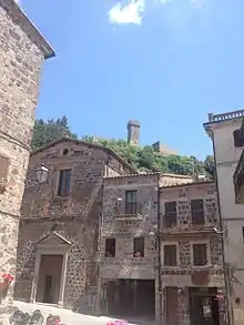
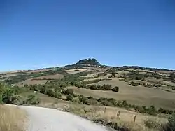 View of Radicofani | |
Location of Radicofani 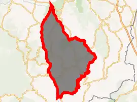
| |
 Radicofani Location of Radicofani in Italy 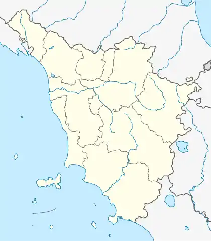 Radicofani Radicofani (Tuscany) | |
| Coordinates: 42°54′N 11°46′E | |
| Country | Italy |
| Region | Tuscany |
| Province | Siena (SI) |
| Frazioni | Contignano |
| Government | |
| • Mayor | Francesco Fabbrizzi |
| Area | |
| • Total | 85.2 km2 (32.9 sq mi) |
| Elevation | 814 m (2,671 ft) |
| Population (31 December 2016)[2] | |
| • Total | 1,088 |
| • Density | 13/km2 (33/sq mi) |
| Demonym(s) | Radicofanesi |
| Time zone | UTC+1 (CET) |
| • Summer (DST) | UTC+2 (CEST) |
| Postal code | 53040 |
| Dialing code | 0578 |
| Website | Official website |
Radicofani borders the following municipalities: Abbadia San Salvatore, Castiglione d'Orcia, Pienza, San Casciano dei Bagni, Sarteano.
Main sights
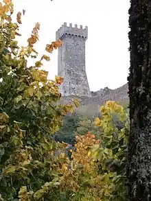
The main landmark of Radicofani is its Rocca (Castle), of Carolingian origin, documented since 978 as the Castle of Ghino di Tacco. Occupying the highest point of a hill, at 896 metres (2,940 ft), it was restored after the conquest from the Grand Duchy of Tuscany (1560–67). It has two lines of walls: the external one has a pentagonal shape, while the inner one is triangular, with three ruined towers at each corner and a cassero (donjon) which can be visited.
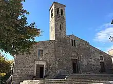
Also notable is the Romanesque church of San Pietro, with a nave housing works by Andrea della Robbia, Benedetto Buglioni and Santi Buglioni. Also by della Robbia is the precious Madonna with Saints at the high altar of the church of Sant'Agata.
Climate
Climate is characterized by relatively high temperatures and evenly distributed precipitation throughout the year. The Köppen Climate Classification subtype for this climate is Cfa (Humid Subtropical Climate).[3]
| Climate data for Radicofani | |||||||||||||
|---|---|---|---|---|---|---|---|---|---|---|---|---|---|
| Month | Jan | Feb | Mar | Apr | May | Jun | Jul | Aug | Sep | Oct | Nov | Dec | Year |
| Average high °C (°F) | 6 (42) |
6 (42) |
8 (47) |
12 (53) |
17 (62) |
21 (69) |
24 (76) |
24 (76) |
21 (69) |
15 (59) |
10 (50) |
7 (44) |
14 (57) |
| Average low °C (°F) | 1 (33) |
1 (33) |
2 (36) |
5 (41) |
9 (49) |
13 (55) |
16 (61) |
16 (61) |
13 (56) |
9 (49) |
5 (41) |
2 (36) |
8 (46) |
| Average precipitation mm (inches) | 46 (1.8) |
51 (2) |
48 (1.9) |
53 (2.1) |
53 (2.1) |
36 (1.4) |
36 (1.4) |
46 (1.8) |
58 (2.3) |
69 (2.7) |
76 (3) |
56 (2.2) |
630 (24.7) |
| Average precipitation days | 7 | 7.4 | 7.7 | 7.9 | 8.4 | 7 | 3.9 | 5.1 | 5.6 | 7.1 | 8.6 | 8.2 | 83.9 |
| Source: Weatherbase [4] | |||||||||||||
References
- "Superficie di Comuni Province e Regioni italiane al 9 ottobre 2011". Istat. Retrieved 16 March 2019.
- All demographics and other statistics: Italian statistical institute Istat.
- Climate Summary for Radicofani
- "Weatherbase.com". 2013. Retrieved on July 29, 2013.
External links
- Official website
- Rocca di Radicofani (in Italian)

| Authority control |
|---|