Raisin Charter Township, Michigan
Raisin Charter Township is a charter township of Lenawee County in the U.S. state of Michigan. The population was 7,559 at the 2010 census.
Raisin Township, Michigan | |
|---|---|
| Raisin Charter Township | |
 Raisin Charter Township Offices | |
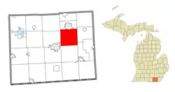 Location within Lenawee County | |
 Raisin Township Location within the state of Michigan | |
| Coordinates: 41°56′42″N 83°56′45″W | |
| Country | United States |
| State | Michigan |
| County | Lenawee |
| Established | 1826 |
| Government | |
| • Supervisor | Dale Witt |
| • Clerk | Marge McDermott |
| Area | |
| • Total | 36.5 sq mi (94.4 km2) |
| • Land | 36.3 sq mi (93.9 km2) |
| • Water | 0.2 sq mi (0.5 km2) |
| Elevation | 732 ft (223 m) |
| Population (2010) | |
| • Total | 7,559 |
| • Density | 209.2/sq mi (80.8/km2) |
| Time zone | UTC-5 (Eastern (EST)) |
| • Summer (DST) | UTC-4 (EDT) |
| ZIP code(s) | |
| Area code(s) | 517 |
| FIPS code | 26-66840[1] |
| GNIS feature ID | 1626950[2] |
| Website | raisinchartertownship |
Geography
According to the United States Census Bureau, the township has a total area of 36.5 square miles (95 km2), of which 36.2 square miles (94 km2) is land and 0.2 square miles (0.52 km2) (0.55%) is water. The most recent flag was designed by Scotty Magee of Adrian in 2006.
Communities
- East Raisin was an area in the eastern part of the township. Euro-American settlement in this area began in 1816 and a community developed.[3]
Demographics
At the 2000 census,[1] there were 6,507 people, 2,265 households and 1,845 families residing in the township. The population density was 179.5 per square mile (69.3/km2). There were 2,347 housing units at an average density of 64.7 per square mile (25.0/km2). The racial makeup of the township was 96.00% White, 0.54% African American, 0.43% Native American, 0.49% Asian, 1.54% from other races, and 1.00% from two or more races. Hispanic or Latino of any race were 4.81% of the population.
There were 2,265 households, of which 40.1% had children under the age of 18 living with them, 71.5% were married couples living together, 7.1% had a female householder with no husband present, and 18.5% were non-families. 15.1% of all households were made up of individuals, and 5.4% had someone living alone who was 65 years of age or older. The average household size was 2.85 and the average family size was 3.17.
28.7% of the population were under the age of 18, 6.8% from 18 to 24, 29.5% from 25 to 44, 26.4% from 45 to 64, and 8.5% who were 65 years of age or older. The median age was 36 years. For every 100 females, there were 97.4 males. For every 100 females age 18 and over, there were 98.6 males.
The median household income was $57,088 and the median family income was $59,977. Males had a median income of $44,973 vand females $25,614. The per capita income was $21,703. About 1.9% of families and 2.9% of the population were below the poverty line, including 1.2% of those under age 18 and 7.1% of those age 65 or over.
References
Notes
Sources
- Romig, Walter (October 1, 1986) [1973]. Michigan Place Names: The History of the Founding and the Naming of More Than Five Thousand Past and Present Michigan Communities. Great Lakes Books Series (Paperback). Detroit, Michigan: Wayne State University Press. ISBN 978-0-8143-1838-6.
External links
- Raisin Charter Township
- Lenawee County government site
- Complete text of History of Lenawee County published in 1909 by the Western Historical Society
Municipalities and communities of Lenawee County, Michigan, United States | ||
|---|---|---|
| Cities | 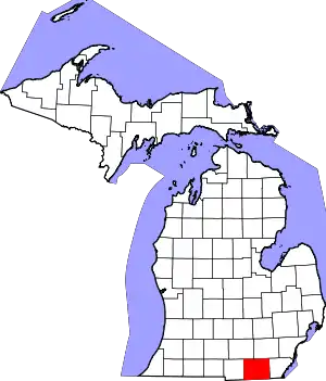 Map of Michigan highlighting Lenawee County.svg | |
| Villages | ||
| Charter townships | ||
| Civil townships | ||
| CDPs | ||
| Other unincorporated communities | ||
| Footnotes | ‡This populated place also has portions in an adjacent county or counties | |
| ||