Raja Village
Raja ![]() Rājāh (Urdu, Punjabi: راجہ) is a village of Gujranwala District located in Punjab, Pakistan
Rājāh (Urdu, Punjabi: راجہ) is a village of Gujranwala District located in Punjab, Pakistan
Raja راجہ | |
|---|---|
Village | |
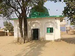 Darbar Baba Wali Shah Dola Raja | |
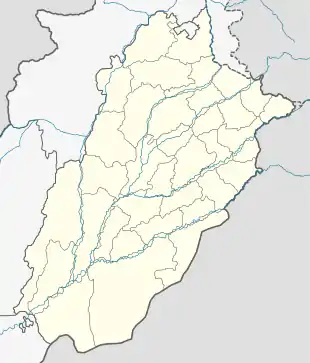 Raja راجہ Location in Pakistan  Raja راجہ Raja راجہ (Pakistan) | |
| Coordinates: 31°54′3″N 74°13′29″E | |
| Country | |
| Region | Punjab |
| District | Gujranwala District |
| Tehsil | Kamoke Tehsil |
| Union Council | Sadhoke |
| Elevation | 218 m (715 ft) |
| Population (2010) | |
| • Total | 4,200 |
| Time zone | UTC+5 (PST) |
| • Summer (DST) | UTCNA (PDT) |
| Postal code | 52368 |
| Dialling code | 055 |
| Raja is a small Village near Sadhoke | |
Religon
Muslims are in Majority
(Hanfi Bareelvi)(Ahlehadees)(Hanfi Dewbandi)(Fikkah Jafria)(Toheedi Sect)
Christions are in Minority also residing here
Mosques
Jamia Masjid Sadiqia Rizvia (Hanfi Bareelvi)
Jamia Masjid Ahlehadees (Ahlehadees)
Jamia Masjid Madni (Hanfi Dewbandi)
Masjid Alhayat (Hanfi Dewbandi)
Jamia Masjid Toheed (Toheedi Sect)
Imam Bargah Husania Masjid (Fikkah Jafria)
Schools and education
Govt. Primary School for Boys
Govt. Primary School for Girls
Govt. High School for boys
Sapna Model School
Sir Sayed Model School
Banks
MCB Bank Limited (Raja Sadhoke Branch),[1] The only one online bank in this area. 1LINK, MNET, VISA, MASTERCARD, PayPak,UnionPay ATM Active 24/7.
Agriculture
Rice and wheat are the basic crops cultivated in the area
Hospitals
Basic Health Unit Raja.
Transportation
Main High Way is N-5 Grand Trunk Road passing through sadhoke which is connected by Baig Pur Road and Canal Road
Baig Pur Road passing through many small villages ends at Baig Pur Village
Telecommunications
PTCL = PSTN and DSL
JAZZ = Cellular with 4G LTE indoor Services
Telenor = Cellular with 4G Services
Zong = Cellular with 4G Services
Ufone = Cellular with 3G Services
PTCL EVO = Charji EVO
Climate
Weather conditions for Raja Village are dominated by its geographical location.
The summer season is long and hot. The piercing sunrays may raise the temperature up to 46 °C (115 °F).
| Climate data for Raja | |||||||||||||
|---|---|---|---|---|---|---|---|---|---|---|---|---|---|
| Month | Jan | Feb | Mar | Apr | May | Jun | Jul | Aug | Sep | Oct | Nov | Dec | Year |
| Average high °C (°F) | 18 (64) |
21 (69) |
26 (78) |
33 (91) |
39 (102) |
40 (104) |
35 (95) |
33 (91) |
34 (93) |
32 (89) |
26 (78) |
20 (68) |
29 (84) |
| Average low °C (°F) | 5 (41) |
8 (46) |
12 (53) |
18 (64) |
23 (73) |
26 (78) |
26 (78) |
25 (77) |
23 (73) |
17 (62) |
10 (50) |
5 (41) |
16 (60) |
| Average rainfall cm (inches) | 4.1 (1.6) |
4 (1.6) |
4.4 (1.7) |
2.1 (0.8) |
1.7 (0.7) |
6.8 (2.7) |
27.1 (10.7) |
25.6 (10.1) |
13.2 (5.2) |
1.4 (0.6) |
1.1 (0.4) |
2.1 (0.8) |
93.6 (36.8) |
| Source: Climate-Data.org[2] | |||||||||||||
Geography
Destinations from Raja | ||||||||||
|---|---|---|---|---|---|---|---|---|---|---|
| ||||||||||
Nearby locations
Sadhoke 1 km east side
Muridke 13 km South via Sadhoke
kamoke 10 km North via Sadhoke
Sheikhupura 30 km West via Baig pur road
Gujranwala 30 km North via sadhoke
Lahore 35 km South via Sadhoke
Major tribes
The Rajputs and Jats are major tribe. The principal clans are Virk Gill Rajput Mughal sayed Ansari Kumar Arain Mochi Minhas Bhatti Qureshi Julah Chowkidar Bajwa residing here.