Rapa Iti
Rapa, sometimes called Rapa Iti, or "Little Rapa," to distinguish it from Rapa Nui, or Big Rapa (a name for Easter Island), is the largest and only inhabited island of the Bass Islands in French Polynesia. An older name for the island is Oparo.[3] The total land area including offshore islets is 40.5 km2 (15.6 sq mi).[4]:205 As of the 2017 census, Rapa had a population of 507.[1] The island's highest point is at 650 metres (2,130 ft) elevation at Mont Perahu.[4]:243 Its main town is Ahuréi. The inhabitants of Rapa Iti speak their own Polynesian language called the Rapa language.
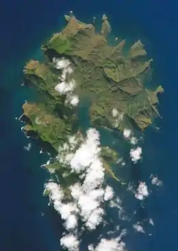 NASA picture of Rapa | |
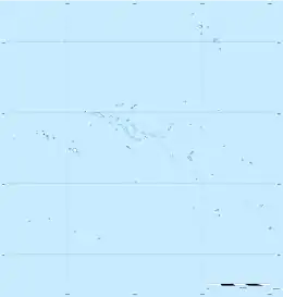 Rapa Iti Rapa Iti is located in French Polynesia | |
| Geography | |
|---|---|
| Location | Pacific Ocean |
| Coordinates | 27°36′S 144°20′W |
| Archipelago | Australes |
| Area | 40.5 km2 (15.6 sq mi) |
| Highest elevation | 650 m (2130 ft) |
| Highest point | Mount Perahu |
| Administration | |
France | |
| Overseas collectivity | French Polynesia |
| Commune | Rapa Iti |
| Demographics | |
| Population | 507[1] (2017) |
Rapa | |
|---|---|
 Flag | |
 | |
Location of Rapa 
| |
| Coordinates: 27°36′S 144°20′W | |
| Country | France |
| Overseas collectivity | French Polynesia |
| Subdivision | Austral Islands |
| Government | |
| • Mayor (2020–2026) | Tuanainai Narii[2] |
| Area 1 | 40.54 km2 (15.65 sq mi) |
| Population (2017)[1] | 507 |
| • Density | 13/km2 (32/sq mi) |
| Time zone | UTC−10:00 |
| INSEE/Postal code | 98741 /98751 |
| Elevation | 0–650 m (0–2,133 ft) |
| 1 French Land Register data, which excludes lakes, ponds, glaciers > 1 km2 (0.386 sq mi or 247 acres) and river estuaries. | |
Geography
Rapa Iti is located at 27°35′00″S 144°20′00″W. It is shaped roughly like a Greek final sigma (ς), with a well-protected central bay, surrounded by a ring of relatively high mountains. The whole island appears to be the peak of a sinking volcano, with the bay as well as the caldera. The area of the main island is 38.5 km2. Little Rapa Tauturau is an offshore island.
Its main town, Ahuréi (or Ha'uréi), lies on the southern shore of that bay, which is called the Baie d'Ahuréi. A smaller village, 'Area, is located on the northern shore of the bay. The people are Polynesian. Former times' warfare is indicated by 28 extant ridgetop forts. Today Rapa is home to the Tahitian Choir, in which a third of the island's population sing traditional songs.
Although sometimes considered part of the Austral Islands, Rapa Iti and the Bass Islands have a different geological, linguistic and cultural history.[5]
History
Rapa Iti was first settled by Polynesians, most likely in the 13th century. Their Polynesian dialect developed into what is today the Rapa language over the centuries.[6] It is believed that the depletion of natural resources on the island resulted in warfare, and the inhabitants lived in up to 14 fortified settlements ("pa" or "pare", a type of fort) on peaks and clifftops.[7] It is considered that the oldest of these is Morongo Uta, which was developed c. 1450–1550 AD.
The first European to visit Rapa Iti was George Vancouver on 22 December 1791;[8] he named the island Oparo. Contact with Europeans brought liquor and disease, and between 1824 and 1830 over three quarters of the natives died.[8] Peruvian slavers raided the island as well.[9] When a handful of their victims were returned to the island, they brought with them smallpox, which caused an epidemic.[9] In 1826, there were almost 2000 inhabitants; forty years later, there were fewer than 120.[10]
The independent island kingdom was declared a French protectorate in 1867. The British established a coaling station on the island, which prompted France to formally annex it on 6 March 1881. Subsequently, the native monarchy was abolished and the last queen, the daughter or Parima, was deposed on 18 June 1887.
Thor Heyerdahl, notably, made excavations in Morongo Uta, seeking links between Rapa Iti and Rapa Nui (Easter Island).
Climate
Rapa is well south of the Tropic of Capricorn, leading to its oceanic and humid subtropical climate classifications. The island is devoid of coconuts due to the island's cool winters, when temperatures can drop below 9 °C (48 °F) at night. Summers on Rapa are typically mild and devoid of extreme heat. The island is very windy and receives about 2,500 mm of annual rainfall.
Environment
The Manatau French Polynesian Reserve is a special French Polynesian Reserve to protect the animals and ridgetop forts of an area of southern Rapa. It is located near South Ahuréi.
The island is home to the endemic and critically endangered Rapa fruit dove which is threatened by habitat loss, predation by feral cats and hunting. Its population was estimated in 2017 at 160 individual birds. Other birds include the least concern Murphy's petrel, the critically endangered Newell's shearwater, both of which nest there in small numbers, and the near threatened bristle-thighed curlew which is a non-breeding visitor while migrating. Because of its significance for these species the island has been identified as an Important Bird Area by BirdLife International.[11]
Administration
The commune of Rapa consists of the island of Rapa Iti and the four uninhabited Marotiri rocks.
References
- Répartition de la population en Polynésie française en 2017, Institut de la statistique de la Polynésie française
- Maires au 17-06-2020, data.gouv.fr, accessed 7 December 2020
- Tahiti guide
- Environnement marin des îles Australes
- F. Allan Hanson, Rapan Lifeways (1970)
- CDNN Archived August 29, 2006, at the Wayback Machine
- "Douglas Kennett, Atholl Anderson, Matthew Prebble, Eric Conte & John Southon. Prehistoric human impacts on Rapa, French Polynesia" (PDF).
- Richards, Rhys. "The Earliest Foreign Visitors and Their Massive Depopulation of Rapa-iti from 1824 to 1830". Journal de la Société des Océanistes.
- Brash, Celeste; Jean-Bernard Carillet (2009). Tahiti and French Polynesia. Lonely Planet. pp. 236–237. ISBN 978-1741043167. Retrieved November 6, 2012.
- Anderson, Warwick (2000). "Infectious Diseases: Colonising the Pacific? (review)" (PDF). Bulletin of the History of Medicine. 74 (3): 617. doi:10.1353/bhm.2000.0103. S2CID 72696414.
- "Rapa". BirdLife data zone: Important Bird Areas. BirdLife International. 2012. Retrieved 2012-12-27.
- F. Allan Hanson (1973). Rapa: une île polynésienne hier et aujourd'hui. Société des Océanistes.
External links
| Wikimedia Commons has media related to Rapa Iti. |
- Information from website of the government of French Polynesia (article not found)
- Article about a scientific study on the social history and development of Rapa Iti society (article not found)
| Authority control |
|---|
