Rayavaram, Tamil Nadu
Rayavaram is a village Panchayat in Pudukkottai district in Tamil Nadu, India.
Rayavaram | |
|---|---|
village Panchayat | |
      | |
| Nickname(s): | |
 Rayavaram  Rayavaram | |
| Coordinates: 10.25°N 78.81°E | |
| Country | India |
| State | Tamil Nadu |
| District | Pudukkottai |
| Government | |
| • Type | Village Panchayat |
| Population (2011) | |
| • Total | 14,643 |
| Languages | |
| • Official | Tamil, English |
| Time zone | UTC+5:30 (IST) |
| PIN | 622 506 |
| Telephone code | 914333 |
| Vehicle registration | TN 55 |
| Website | www |
Geography
Rayavaram lies 72 kilometres (45 mi) south of Tiruchirappalli and 90 kilometres (56 mi) north of Madurai. The nearest town is Pudukkottai. The closest airport is at Tiruchirappalli. It is well connected by road and has at least 75 buses covering surrounding areas.
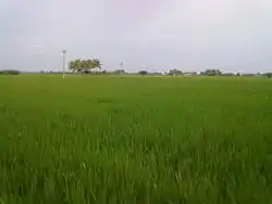
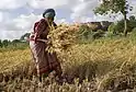
The village's economy is based on agriculture.
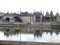
Water bodies
The village has several oorani (small tanks) and kulam (vast spans of water storage) like Rayavaram Kanmai, Chettipatti Kanmai, Palayaoorni, Puduroorani and Nallanchetti Oorani, Olagankathan, Ponachi, Narayanan Chetti Oorani, Poochetti Oorani, Nalanchetti Oorani, Ayyanar kovl Oorani, Koththathi Kanmai, Kurunthangudi Kanmai, Ayungudi Kanmai, Aalangudi Kanmai and Valayan vayal Kanmai.
1. பழைய ஊரணி
2. சிவன் கோவில் ஊரணி
3. புது ஊரணி
4. நாராயணன் செட்டியார் ஊரணி
5. நல்லான் செட்டியார் ஊரணி
6. பொன்னாச்சி ஊரணி
7. ஆண்டி ஊரணி
8. உலகங்காத்தான் ஊரணி
9. வாடி ஊரணி
கண்மாய்கள்
1. ராயவரம் கண்மாய்
2. கொத்தத்தி கண்மாய்
3.குறுந்தங்குடி கண்மாய்
4.ஆயிங்குடி கண்மாய்
5.செங்கீரை கண்மாய்
6. செட்டி கண்மாய்
Demographics
As of 2001,[1][2] Rayavaram had a population of 14,643. Males constituted 49% of the population and females 51%. Rayavaram had an average literacy rate of 75%, higher than the national average of 59.5%; with 54% of the males and 46% of females literate. 12% of the population was under 6 years of age.
Transport
Rayavaram had well connected with road. Bus station had Provided to travel with Thirumayam, Pudukkottai, Karaikudi, Sivaganga, Aranthangi, Arimalam, Devakottai, Dindigal, Thiruchirapalli, Coimbatore, Madurai and Chennai.
The Nearest Railway stations is Thirumayam and Pudukkottai railway station. The Nearest Airport is Tiruchirappalli International Airport and Madurai International Airport.
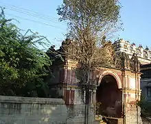
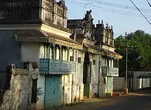
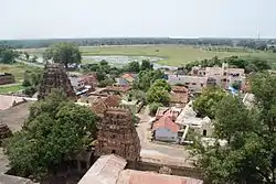
Temple
- 1 Sri Rock Cut Shiva temple https://www.google.com/maps/place/%E0%AE%95%E0%AF%81%E0%AE%9F%E0%AF%88%E0%AE%B5%E0%AE%B0%E0%AF%88+%E0%AE%95%E0%AF%8B%E0%AE%B5%E0%AE%BF%E0%AE%B2%E0%AF%8D+%E0%AE%9A%E0%AE%BF%E0%AE%B5%E0%AE%A9%E0%AF%8D+%E0%AE%95%E0%AF%8B%E0%AE%9F%E0%AF%8D%E0%AE%9F%E0%AF%88%E0%AE%AF%E0%AF%82%E0%AE%B0%E0%AF%8D+%E0%AE%B0%E0%AE%BE%E0%AE%AF%E0%AE%B5%E0%AE%B0%E0%AE%AE%E0%AF%8D/@10.2468821,78.7987572,16z/data=!4m5!3m4!1s0x0:0xa192f0c0f00ad195!8m2!3d10.250283!4d78.7983897
- 2 Sri Muthumari Amman temple https://www.google.com/maps/place/Rayavaram+Sri+Muthumari+Amman+Charitable+Trust/@10.2495713,78.8093035,17z/data=!4m5!3m4!1s0x3b007acc0cd531b3:0x7f6a69edf7ba2844!8m2!3d10.249606!4d78.8094217
- 3 Sri Iththimaraththu Vinayakar temple https://www.google.com/maps/place/Itthimarathu+Pillayar+Kovil/@10.2396613,78.8067876,17z/data=!4m5!3m4!1s0x3b00653406b2643f:0x9bcd372942deda8f!8m2!3d10.2402782!4d78.8102531
- 4 Sri Shivan temple https://www.google.com/maps/place/Shri+Meenakshi+Sundareswarar+Temple+(Shiva+Temple)/@10.2500827,78.8103831,20z/data=!4m5!3m4!1s0x3b007acbf65341e1:0xdc2b243f010d0adf!8m2!3d10.2500864!4d78.8100976
- 5 Sri Perumal temple https://www.google.com/maps/place/Shri+Perumal+Kovil/@10.250016,78.8102503,19z/data=!4m5!3m4!1s0x3b007acbf87c382d:0x29e44a7fb06cd4d2!8m2!3d10.2504189!4d78.8099742
- 6 Sri Malaikuluthu temple https://www.google.com/maps/place/Shri+Malaikkoluntheeswarar+Temple/@10.239196,78.8078982,16z/data=!4m5!3m4!1s0x3b006531654324ef:0x8c387f362aea5abb!8m2!3d10.239196!4d78.8078982
- 7 Sri Anjinear temple https://www.google.com/maps/place/Anjiear+temple/@10.2501975,78.8070853,17z/data=!4m5!3m4!1s0x3b007ace75785179:0x4ae5e7e1b5c9f7c5!8m2!3d10.2508419!4d78.8058664
- 8 Sri Ayyanar temple https://www.google.com/maps/place/%E0%AE%85%E0%AE%AF%E0%AF%8D%E0%AE%AF%E0%AE%A9%E0%AE%BE%E0%AE%B0%E0%AF%8D+%E0%AE%95%E0%AF%87%E0%AE%BE%E0%AE%AF%E0%AE%BF%E0%AE%B2%E0%AF%8D/@10.2519864,78.8057469,17z/data=!4m5!3m4!1s0x3b007ace7b323a6b:0x8cb65644edbec799!8m2!3d10.2515064!4d78.8066362?shorturl=1
- 9 Senkeerai Munnodi Karuppar temple
- 10 Senkeerai Ayyanaar temple
கோவில்கள்
1. குடைவரை கோவில் சிவன் கோட்டையூர் ராயவரம் https://goo.gl/maps/6Sj7YzBm3UFXuvrc6
2. ஸ்ரீ மலைக்கொழுந்திஸ்வரர் குடவரை சிவன் கோயில் https://goo.gl/maps/VCgzxtcHoTM5Bb346
3. ஸ்ரீ இத்திமரத்து பிள்ளையார் கோவில் https://goo.gl/maps/EZfPbGdcK1Nttrf49
4. ஸ்ரீ முத்துமாரியம்மன் கோயில் https://goo.gl/maps/dATPWQYu8GivWLc6A
5. ஸ்ரீ பெருமாள் கோவில் https://goo.gl/maps/eFx6L1R9CXfgHj1U8
6. ஸ்ரீ சிவன் கோவில். https://goo.gl/maps/zBqDP8zhtcVevmhR6
7. ஸ்ரீ ஆஞ்சேநேயர் கோவில் https://goo.gl/maps/TX5Hj4SD4kB4x4cF7
8. ஸ்ரீ அய்யனார் கோயில் https://goo.gl/maps/wQiHkkJfQoJumFzXA
References
| Wikimedia Commons has media related to Rayavaram, Tamil Nadu. |
- "Census of India 2001: Data from the 2001 Census, including cities, villages and towns (Provisional)". Census Commission of India. Archived from the original on 16 June 2004. Retrieved 1 November 2008.
- Tamilnadu Census
| Towns |  | |
|---|---|---|
| Villages |
| |
| Temples |
| |
| Notable Chettiars | ||
| Related | ||