Regions of Malta
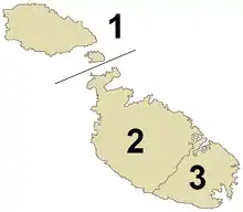
Malta is subdivided into 5 regions (Maltese: reġjuni). Three regions were originally created by the Local Councils Act of 1993, and were integrated into the constitution in 2001.[1] Two of the regions were split into smaller ones by Act No. XVI of 2009, and now there are five regions.[2]
 |
|---|
| This article is part of a series on the politics and government of Malta |
Each region has a Regional Committee (Maltese: Kumitat Reġjonali), which consists of a Regional President, a Vice President, an Executive Secretary and between 10 and 14 members.[3]
List
Current regions
| Coat of arms | Region | Seat | Largest city | Area | Population (2014) | Population density | Established |
|---|---|---|---|---|---|---|---|
| Central Region | San Ġwann | Birkirkara | 23.6 km2 (9.1 sq mi) | 111,994 | 4,700/km2 (12,000/sq mi) | 2009 | |
| Gozo Region | Victoria | Victoria | 68.7 km2 (26.5 sq mi) | 37,342 | 540/km2 (1,400/sq mi) | 1993 | |
| Northern Region | St. Paul's Bay | St. Paul's Bay | 112.9 km2 (43.6 sq mi) | 102,892 | 910/km2 (2,400/sq mi) | 2009 | |
| South Eastern Region | Tarxien | Żabbar | 36.2 km2 (14.0 sq mi) | 99,301 | 2,700/km2 (7,000/sq mi) | 2009 | |
| Southern Region | Qormi | Qormi | 78.9 km2 (30.5 sq mi) | 93,897 | 1,200/km2 (3,100/sq mi) | 2009 | |
Former regions

1993–2009
| Region | Largest city | Area | Population (2005) | Population density | Established | Abolished |
|---|---|---|---|---|---|---|
| Malta Majjistral | Birkirkara | 163 km2 (63 sq mi) | 227,117 | 1,393/km2 (3,610/sq mi) | 1993 | 2009 |
| Malta Xlokk | Żabbar | 64 km2 (25 sq mi) | 140,882 | 2,201/km2 (5,700/sq mi) | 1993 | 2009 |
References
| Wikimedia Commons has media related to Regions of Malta. |
- "Malta" (PDF). Assembly of European Regions. Archived from the original (PDF) on 8 February 2013. Retrieved 1 April 2015.
- "Regions of Malta". Statoids. Retrieved 1 April 2015.
- Protokol Lokali u Reġjonali (PDF) (in Maltese). Valletta: Dipartiment tal-Informazzjoni. pp. 5–6. Retrieved 1 April 2015.
This article is issued from Wikipedia. The text is licensed under Creative Commons - Attribution - Sharealike. Additional terms may apply for the media files.