River Lugg
The River Lugg (Welsh: Afon Llugwy) rises near Llangynllo in Radnorshire, Wales. It flows through the border town of Presteigne and then through Herefordshire, England, to the south of Leominster, where it meets a tributary, the River Arrow. Its confluence with the River Wye is at Mordiford, 9 miles (14 km) downstream of Hereford and 45 miles (72 km) from its source. Its name comes from a Welsh root, and means "bright stream".[1]
| River Lugg | |
|---|---|
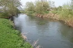 The Lugg at Hampton Bishop | |
| Native name | Afon Llugwy |
| Location | |
| Country | Wales, England |
| Counties | Radnorshire, Herefordshire |
| Settlements | Llangynllo, Presteigne, Leominster, Hope under Dinmore, Bodenham, Marden, Lugwardine |
| Physical characteristics | |
| Source | Llangynllo |
| • location | Radnor Forest, Radnorshire, Wales |
| • coordinates | 52°21′29″N 3°12′20″W |
| • elevation | 497 m (1,631 ft) |
| Mouth | confluence with River Wye |
• location | Mordiford, Herefordshire, England |
• coordinates | 52°01′52″N 2°38′10″W |
• elevation | 46 m (151 ft) |
| Length | 72 km (45 mi) |
| Basin features | |
| Tributaries | |
| • left | River Frome |
| • right | River Arrow |
Navigation
The Environment Agency is the navigation authority for the river. Below Leominster the river was made navigable under the River Wye & Lugg Navigation Act 1696 for improving the River Wye and had pound locks. Despite several attempts to improve it, including making flash locks against bridges, the river was probably never a satisfactory waterway, and commercial navigation probably ceased in the early 19th century. It is still sometimes used by small boats but can be very dangerous when in flood. In February 2020, it was one of several rivers with severe flood warnings following the impact of Storm Dennis.[2][3]
Recreation
The river is popular with canoeists who have undisputed rights of navigation. However travelling from Leominster to Hereford is challenged by numerous fallen trees obstructing the river.[4][5] It is a good fishing river.[6][7]
Environment
In November/December 2020, damage was done to a 1.5-mile (2.4 km) stretch of the riverbank near Kingsland in Herefordshire.[lower-alpha 1] The damaged area, which was part of the SSSI, was home to protected wildlife including crayfish, otters, salmon, and lampreys. It was discovered that trees had been felled, river-bed gravel removed, the meanders straightened, and all vegetation in the area had been dug up by bulldozer, without permission, leaving the riverbank devastated.[8][9]
A lawyer for Salmon and Trout Conservation, who is also a local resident, said:[10]
This is one of the most egregious acts of ecological vandalism that I have seen in 25 years of working on rivers in the UK
The Environment Agency, Natural England and the Forestry Commission interrupted the work, preventing further damage. Herefordshire Wildlife Trust said the changes would have "huge repercussions for wildlife downstream" and urged that the landowner responsible be prosecuted.[10][9]
Notes
- The affected riverbank runs west from the bridge at 52.25441°N 2.80907°W, on the north side of the river.
References
- Ekwall, Eilert (1947). The Concise Oxford Dictionary of English Place-Names. Oxford: The Clarendon Press. p. 292.
- "Storm Dennis: Fears for Severn towns amid fresh flood warnings". BBC News. Retrieved 18 February 2020.
- "Severe flood alerts in Monmouthshire, Herefordshire and Worcestershire as waters rise along River Wye, Lugg and Severn". Gloucestershire Live. Retrieved 18 February 2020.
- Garcia, Carmelo. "Hereford Times". Retrieved 28 September 2020.
- "UK Rivers website". Archived from the original on 17 October 2007. Retrieved 28 November 2007.
- "Total Fishing Gear". Archived from the original on 29 September 2007. Retrieved 28 November 2007.
- "Dwylon". Archived from the original on 27 September 2007. Retrieved 28 November 2007.
- James Thomas (4 December 2020). "Environment Agency launch probe into river Lugg destruction". Hereford Times. Retrieved 4 December 2020.
- "Protected River Lugg was 'bulldozed' in 'wildlife crime'". BBC News. 4 December 2020.
- Laville, Sandra (4 December 2020). "Police move in after Herefordshire river bulldozed and straightened". The Guardian. Retrieved 4 December 2020.
Further reading
- I. Cohen, 'The non-tidal Wye and its navigation' Trans. Woolhope Nat. Field. Club XXXV (1955-7), 83-101
- A. Brian, '"As to the Lugg": its vanished mills, broken weirs and damaged bridges’ Ibid. XLVIII(1) (1994), 36-96.
External links
| Wikimedia Commons has media related to River Lugg. |
| Authority control |
|
|---|