Flash lock
Early locks were designed with a single gate, known as a flash lock or staunch lock. The earliest European references to what were clearly flash locks were in Roman times.[3]
Development


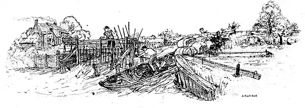
In England the "gate" was similar to a temporary needle dam: a set of boards, called paddles, supported against the current by upright timbers called rymers which normally kept the level of water above it to navigable levels. Boats moving downstream would wait above the lock until the paddles were removed, which would allow a "flash" of water to pass through, carrying the boats with it. Upstream boats would be winched or towed through the lock with the paddles removed. Considerable skill was involved both in removing the paddles in a timely manner and navigating the boat through the lock. Flash locks of this type have been documented since at least 1295 C.E.[4]
Flash locks were commonly built into small dams or weirs where a head of water was used for powering a mill. The lock allowed boats to pass the weir while still allowing the mill to operate when the gate was closed. However it could take up to a day or even more to restore the water levels after a boat had passed, so their use was unpopular with the millers.
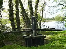
As navigation increased in importance, improvements were made to the basic design, and they came to be known by various names according to where they were located. Thus on the Thames they were called navigation weirs, on the East Anglian rivers they were called staunches, those on the River Avon, Warwickshire were called water gates, and in a number of instances they were called half locks. On the River Nene and some of the tributaries of the River Great Ouse, a design using a guillotine gate in a wooden frame was used from the early seventeenth century onwards. The gate was opened by operating a large spoked wheel, connected by chains to a toothed drum.[5]
The pound lock holds water between two gates, and is considerably easier to navigate. Pound locks have been built in China since 983, in the Netherlands from 1065 and in Britain from the 1560s. Nevertheless, a few flash locks remained after the introduction of pound locks. Flash locks on the Nene continued to be used until they were replaced in a programme of modernisation, which included building new locks, carried out between 1936 and 1941. The last flash lock on the Thames was Hart's Lock, which lasted until 1937, while on the Lower Avon, the structure of Cropthorne Water Gate lasted until the reopening of the river to navigation in 1961, although it had not been used for navigation for many years before that. Although slightly different in concept, Thames Lock at Weybridge on the Wey Navigation had an additional single gate some 100 yards (91 m) below the lock, which when closed raises the water level above it, allowing boats which would normally foul the cill to work through the lock. It continued in use until 1969, to enable grain barges to use the lock, and although grain traffic stopped in that year, it recommenced in 1981, when the gate was again used.[6] The gate is still used at the lock-keeper's discretion for boats which have a draught exceeding 1.75 feet (0.53 m).[7]
Paddle and rymer weirs


The weirs which are the remnants of flash locks can still be seen on the River Thames though they are not used any more for navigation as regular pound locks were introduced in the eighteenth and nineteenth centuries and the last flash lock removed in 1937.[4] The Environment Agency is now involved in a programme of replacing these,[8] as their manual operation is considered to be dangerous, and involves lifting weights which exceed those recommended by the Manual Handling Operations Regulations 1992.[9]
Two or three paddles are stacked between each of the rymers, which slot into a beam placed on the bottom of the river. The paddles are of differing lengths allowing a very fine adjustment of the amount of water flowing through the weir.[10]
Four of these weirs were replaced in 2009. Three were on the Thames at Mapledurham, Molesey and Radcot, while the fourth was at Blake's Lock, the first lock on the River Kennet, which is managed as part of the Thames. Three more of these weirs, at Rushey, Goring and Streatley, have been Grade II listed since 2009, but the EA is proposing to replace most of Rushey, which would be the only full-width example left.[9]
References
- Taken from an information board provided by the Environment Agency at the upstream junction of the Swift Ditch with the River Thames at Abingdon
- A copyrighted 1925 photograph of a Steam vessel negotiating the flash lock at Medley Weir may be seen here
- "Archived copy". Archived from the original on 24 April 2012. Retrieved 28 September 2011.CS1 maint: archived copy as title (link) Paper presented to conference of Oxford Roman Economy Project, 9 May 2009
- Paddle and Rymer Weirs on the Thames, OA Library, retrieved 28 September 2011
- McKnight (1981), pp. 33–34.
- McKnight (1981), p. 34.
- Nicholson (2006), p. 178.
- Environment Agency, Paddle and Rymer weir, retrieved 28 September 2011
- "Paddle & Rymer Weirs Replacement Programme Scoping Consultation Document PACKAGE 2 – RUSHEY WEIR" (PDF). Environment Agency. July 2011. Retrieved 28 September 2011.
- Mullinuex, Chris. "Northmoor Paddle and Rhymer Weir". Archived from the original on 8 July 2013. Retrieved 28 February 2014.
Bibliography
- McKnight, Hugh (1981). Shell Book of Inland Waterways. David and Charles. ISBN 978-0-7153-8239-4.
- Nicholson (2006). Nicholson Guide Vol 7 - River Thames & the Southern Waterways. Harper Collins. ISBN 978-0-00-721115-9.


