Rivière de la Grande Coudée
The rivière de la Grande Coudée (in English: river of the great cub) is a tributary of the west bank of the Chaudière River which flows northward to empty onto the south bank of the St. Lawrence River. It flows in the municipalities of Saint-Hilaire-de-Dorset, Saint-Gédéon-de-Beauce and Saint-Martin, in the Beauce-Sartigan Regional County Municipality, in the administrative region of Chaudière-Appalaches, in Quebec, in Canada.
| Rivière de la Grande Coudée | |
|---|---|
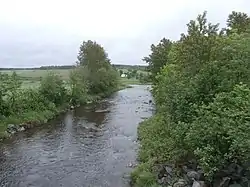 Rivière de la Grande Coudée towards its confluence with the Chaudière river. | |
 | |
| Location | |
| Country | Canada |
| Province | Quebec |
| Region | Chaudière-Appalaches |
| MRC | Beauce-Sartigan Regional County Municipality |
| Physical characteristics | |
| Source | Forest streams |
| • location | Saint-Hilaire-de-Dorset |
| • coordinates | 45.783254°N 70.772419°W |
| • elevation | 428 metres (1,404 ft) |
| Mouth | Chaudière River |
• location | Saint-Martin |
• coordinates | 45.93028°N 70.65444°W |
• elevation | 230 metres (750 ft) |
| Length | 32.4 kilometres (20.1 mi) |
| Basin features | |
| Progression | Chaudière River, St. Lawrence River |
| River system | St. Lawrence River |
| Tributaries | |
| • left | (upstream) décharge du Lac des Îles, ruisseau des Cèdres |
| • right | (upstream) décharge du Lac des Îles, ruisseau des Cèdres |
Geography
The main neighboring watersheds of the Grande Coudée river are:
- north side: Shenley River, Roy brook, Pozer River, Chaudière River;
- east side: Petit Portage River, Chaudière River;
- south side: Petit Portage River, Ludgine River;
- west side: Ludgine River, Rivière aux Bluets.[1]
The Grande Coudée river has its source in a swamp straddling the townships of Dorset and Gayhurst, very close (north side) of the boundary between the Beauce-Sartigan Regional County Municipality (RCM) and Le Granit Regional County Municipality (RCM). Its source is located 7.3 kilometres (4.5 mi) north-west of the bridge in the village of Saint-Ludger, at 7.8 kilometres (4.8 mi) north-east of Drolet Lake, located in the municipality of Lac-Drolet.[1]
From its source, the Grande Coudée river flows over 32.4 kilometres (20.1 mi) divided into the following segments:
- 2.3 kilometres (1.4 mi) towards the north-west, until the outlet of the Oliveira lake;
- 3.8 kilometres (2.4 mi) towards the north-west, collecting water from a stream in the locality "Les Fourches", until the outlet of Lac Rond;
- 6.7 kilometres (4.2 mi) northeasterly, up to the confluence of the Discharge of Lac des Îles;
- 9.0 kilometres (5.6 mi) northeasterly, winding up to the intermunicipal limit between Saint-Hilaire-de-Dorset and Saint-Gédéon-de-Beauce;
- 1.5 kilometres (0.93 mi) northeasterly, winding up to the intermunicipal limit between Saint-Gédéon-de-Beauce and Saint-Martin;
- 5.6 kilometres (3.5 mi) towards the north-east, winding up to the confluence of a stream (coming from the north-west);
- 3.5 kilometres (2.2 mi) eastward, up to its confluence.[1]
The Grande Coudée River empties on the west bank of the Chaudière River at Saint-Martin. Its confluence is 1.4 kilometres (0.87 mi) upstream from the bridge in the village of Saint-Martin and downstream from the village of Saint-Gédéon-de-Beauce.[1]
Toponymy
In history, this watercourse has often been referred to as the “Grande Coulée”, especially since 1937. In other times, this river has been designated “Grande Coudée” by the inhabitants of this sector; and this name has been attested in particular by Vondenvelden and Charland, 1803, and Bouchette, 1832.
The term "flow" popularly denotes a ravine, usually having an intermittent stream. The term "cubit" reflects the geographical particularities of the course of this river. As early as 1860, pioneers settled at the Grande Coudée, i.e. at the mouth of this watercourse. A Catholic mission will be known there under the name of Grandes-Coudées.[2]
The toponym Rivière de la Grande Coudée was made official on October 19, 1990 at the Commission de toponymie du Québec.[3]
Notes and references
- "Atlas of Canada from the Department of Natural Resources Canada - Characteristics extracted from the geographic map, the database and the site instrumentation". Retrieved 2021-01-05.
- Source: "Names and places of Quebec", work of the Commission de toponymie du Québec, published in 1994 and 1996 in the form of a printed illustrated dictionary, and under that of a CD-ROM produced by the company Micro-Intel, in 1997, from this dictionary.
- Commission de toponymie du Québec - Place names bank - Toponyms: Rivière de la Grande Coudée.