Rock, Kansas
Rock is an unincorporated community in Cowley County, Kansas, United States.[1]
Rock, Kansas | |
|---|---|
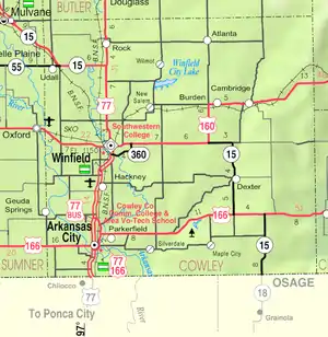 KDOT map of Cowley County (legend) | |
 Rock  Rock | |
| Coordinates: 37°26′25″N 97°0′23″W | |
| Country | United States |
| State | Kansas |
| County | Cowley |
| Elevation | 1,175 ft (358 m) |
| Time zone | UTC-6 (CST) |
| • Summer (DST) | UTC-5 (CDT) |
| ZIP code | 67131 |
| Area code | 620 |
| FIPS code | 20-60400 |
| GNIS ID | 470206 |
History
19th century
The post office was established August 12, 1870.[2]
In 1877, the Florence, El Dorado, and Walnut Valley Railroad Company built a branch line from Florence to El Dorado, in 1881 it was extended to Douglass, and later to Arkansas City.[3] The line was leased and operated by the Atchison, Topeka and Santa Fe Railway. The line from Florence to El Dorado was abandoned in 1942.[4] The original branch line connected Florence, Burns, De Graff, El Dorado, Augusta, Douglass, Rock, Akron, Winfield, Arkansas City.
20th century
In 1905, the nearby Bucher Bridge, on the National Register of Historic Places, was built.
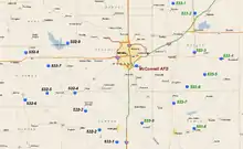
On Aug 24, 1978, the community was evacuated when a major oxidizer spill at a Titan II ICBM site (533-7) 2.5 miles south of Rock.[5] The spill resulted in the deaths of 2 airmen that were based out of the 381st Strategic Missile Wing, McConnell Air Force Base, approximately 20 miles away.
21st century
In 2010, the Keystone XL Pipeline was constructed about 2.5 miles west of Rock, north to south through Butler County, with much controversy over tax exemption and environmental concerns (if a leak ever occurs).[6][7] A pumping station named Rock was built along the pipeline.
Education
The community is served by Udall USD 463 public school district.
References
- U.S. Geological Survey Geographic Names Information System: Rock, Kansas
- "Kansas Post Offices, 1828-1961, page 2". Kansas Historical Society. Retrieved June 6, 2014.
- Marion County Kansas : Past and Present; Sondra Van Meter; MB Publishing House; LCCN 72-92041; 344 pages; 1972.
- Railway Abandonment 1942
- http://www.techbastard.com/missile/titan2/accident_533-7_1978.php
- Keystone Pipeline - Marion County Commission calls out Legislative Leadership on Pipeline Deal; April 18, 2010. Archived October 22, 2011, at the Wayback Machine
- Keystone Pipeline - TransCanada inspecting pipeline; December 10, 2010.
Further reading
External links
- Cowley County Map, KDOT
- History of Rock, Kansas
- Keystone Oil Pipeline, Detailed system map (near Rock)
Municipalities and communities of Cowley County, Kansas, United States | ||
|---|---|---|
| Cities | 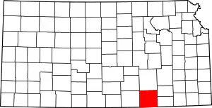 Map of Kansas highlighting Cowley County | |
| Unincorporated communities | ||
| Townships | ||
| Footnotes | ‡This populated place also has portions in an adjacent county or counties | |
| ||