Roetgen
Roetgen is a municipality in the district of Aachen, in North Rhine-Westphalia, Germany.
Roetgen | |
|---|---|
 Coat of arms | |
Location of Roetgen within Aachen district 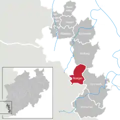 | |
 Roetgen  Roetgen | |
| Coordinates: 50°39′N 6°12′E | |
| Country | Germany |
| State | North Rhine-Westphalia |
| Admin. region | Köln |
| District | Aachen |
| Subdivisions | 3 |
| Government | |
| • Mayor | Jorma Klauss (SPD) |
| Area | |
| • Total | 39.033 km2 (15.071 sq mi) |
| Elevation | 386 m (1,266 ft) |
| Population (2019-12-31)[1] | |
| • Total | 8,648 |
| • Density | 220/km2 (570/sq mi) |
| Time zone | UTC+01:00 (CET) |
| • Summer (DST) | UTC+02:00 (CEST) |
| Postal codes | 52159 |
| Dialling codes | 02471 |
| Vehicle registration | AC |
| Website | www.roetgen.de |
Geography
Roetgen is located approximately 15 km (9 mi) south-east of Aachen, near the border with Belgium. It is in the north of the High Fens-Eifel Nature Park on the Weser stream which rises a few kilometres to the south. Between Roetgen and Rott is the Dreilägerbach Reservoir, which is fed by the Dreilägerbach stream and the artificially Schleebachgraben and Hasselbachgraben ditches. The attached waterworks supplies large parts of Aachen and the Dutch town of Kerkrade with drinking water.
The parish of Roetgen includes the villages of Roetgen, Rott and Mulartshütte, which is the oldest part of Roetgen.
To the northwest is the borough of Aachen with its quarters of Kornelimünster and Walheim, to the northeast is the town of Stolberg with its quarters of Venwegen and Zweifall, to the southeast is the Simmerath parish of Lammersdorf. To the west, on the far side of the German-Belgian border lies the town of Eupen and the municipalities of Raeren, whose parish of Petergensfeld borders immediately on Roetgen north of Charliers Mill.
Roetgen is attractive for commuters due to its close proximity to Aachen.
History
In World War II, Roetgen was the first German town to fall under American control. American forces arrived in the town on 12 September 1944 at 14.30.[2]
The city was the location of the court martial of US Army Private Eddie Slovik in November 1944, notable because of all US military personnel in World War II, only Slovik was ever executed for desertion.
Division of the municipality
Roetgen consists of three districts:
- Roetgen
- Rott
- Mulartshütte
Mulartshütte is the oldest settlement of the three.
Sights
- St. Mary's Chapel (Marienkapelle, 1636–1660) is the surviving part of the first Roman Catholic parish church in Roetgen. It was partially demolished when the Neogothic St. Hubert's Church (1854–1856) was built. It was consecrated to Saint Hubertus of Liège, the Virgin Mary and John the Baptist.
- In Roetgen's town hall is the sculpture of a weaver by Hermann Pier (1925–1985); outside on the forecourt is a replica. It has historical and well as artistic value, because this craft was an important part of Roetgen's economic history.
- Charliers Mill (substructure of rubble stone, 1768) is an old water mill (today a domestic residence) on the Weser stream. In the countryside behind the mill, with its pastures, rows of beech rows and ponds runs Stage 1 of the Eifelsteig hiking trail.
Gallery
 St. Hubert's Roman Catholic Church
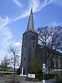
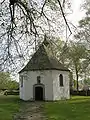 St. Mary's Chapel
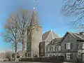 The Protestant church
References
- "Bevölkerung der Gemeinden Nordrhein-Westfalens am 31. Dezember 2019" (in German). Landesbetrieb Information und Technik NRW. Retrieved 17 June 2020.
- New York Times, 14 Sep 1944.
External links
- Official website
 (in German)
Towns and municipalities in Aachen (district) | ||
|---|---|---|
Coat of Arms of Aachen district | ||
| Authority control |
|---|
