Roman Road, Cambridgeshire
The Roman Road in Cambridgeshire is a 12.4 hectare linear biological Site of Special Scientific Interest stretching from south-east of Cambridge to north of Linton.[1][2] It is also a Scheduled Monument,[3] and is maintained by Cambridgeshire County Council.[4]
| Site of Special Scientific Interest | |
 | |
| Area of Search | Cambridgeshire |
|---|---|
| Grid reference | TL 526 520[1] |
| Interest | Biological |
| Area | 12.4 hectares[1] |
| Notification | 1984[1] |
| Location map | Magic Map |
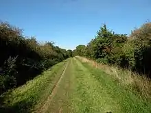
This green lane has calcareous grassland, thick hedges and small copses, which provide a valuable habitat for invertebrates. There are grasses such as sheep’s-fescue and quaking-grass, while herbs include wild carrot and purple milk-vetch.[5]
The date of the road is uncertain, but archaeological excavation has confirmed that it is Roman, and probably constructed later than the first century. It was a local road connecting Cambridge to the Icknield Way.[6]
The road is a public footpath[4] and part of the E2 European long distance path.
References
- "Designated Sites View: Roman Road". Sites of Special Scientific Interest. Natural England. Retrieved 13 December 2016.
- "Map of Roman Road". Sites of Special Scientific Interest. Natural England. Retrieved 13 December 2016.
- "Worstead Street (Via Devana) near Cambridge. List entry Number: 1003263". Historic England. Retrieved 13 December 2016.
- "Roman Road" (PDF). Cambridgeshire County Council. Retrieved 13 December 2016.
- "Roman Road citation" (PDF). Sites of Special Scientific Interest. Natural England. Retrieved 13 December 2016.
- Malim, Tim. "Roman Road". Friends of the Roman Road and Fleam Dyke. Retrieved 13 December 2016.
| Wikimedia Commons has media related to Roman Road. |