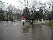
Rooster River
Rooster River is a river in Fairfield County, Connecticut that lies on and serves as the border between Bridgeport and Fairfield.[1] It has flooded on numerous occasions and so has its own flood control project.[2]

Rooster River flooding.
The river is 15.3 square miles in length.[1] Its headwater is heavily urbanized watershed; in addition to Bridgeport and Fairfield, it also runs through Trumbull.[1] Rooster River extends southward into Black Rock Harbor and Long Island Sound by way of the Ash Creek Estuary.[1] The source of the river is Lake Forest in Bridgeport, Horse Tavern Brook in Trumbull, and London's Brook from the Fairchild Wheeler golf course.[2]
See also
References
- Technical Memorandum #1: State of the Rooster River Watershed: Rooster River Watershed Based Plan (March 2013). Fuss & O'Neill, prepared for City of Bridgeport in cooperation with: Connecticut Department of Energy & Environmental Protection Southwest Conservation District.
- "Rooster River Flood Control Project". Stratfield Village Association. Retrieved 2008-09-07.
This article is issued from Wikipedia. The text is licensed under Creative Commons - Attribution - Sharealike. Additional terms may apply for the media files.