Green Fall River
The Green Fall River is a river in the U.S. states of Connecticut and Rhode Island. It flows approximately 13 km (8 mi).
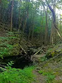
Green Fall River ravine south of Green Fall Pond dam.
Course
The river rises from a swamp south of Rockville Road (CT 138) in Voluntown. The river then flows due south to Green Fall Pond (41.531°N 71.809°W), then continues south through North Stonington and into Hopkinton, Rhode Island where the river converges with Parmenter Brook to form the Ashaway River.
Crossings
Below is a list of all crossings over the Green Fall River. The list starts at the headwaters and goes downstream.
- Voluntown
- Sand Hill Road/Green Fall Rd. just south of the Green Falls Pond Dam near the Rhode Island border.
- North Stonington
- Putker Road
- Clarks Falls Road (CT 216) (Twice)
Tributaries
In addition to many unnamed tributaries, the following brooks also feed the Green Fall:
- Peg Mill Brook
- Palmer Pond Brook
- Glade Brook
This article is issued from Wikipedia. The text is licensed under Creative Commons - Attribution - Sharealike. Additional terms may apply for the media files.