Rosà
Rosà is a town of 14.328 inhabitants in the province of Vicenza, Veneto, Italy. The name comes from the Latin word "roxata", the ancient name of the biggest irrigation channel that passed in that area. The municipality has got 4 hamlets (Travettore, Sant'Anna, San Pietro, Cusinati). Rosà is officially European Town of Sport 2011.
Rosà | |
|---|---|
| Comune di Rosà | |
Location of Rosà 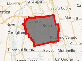
| |
 Rosà Location of Rosà in Italy 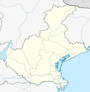 Rosà Rosà (Veneto) | |
| Coordinates: 45°43′N 11°46′E | |
| Country | Italy |
| Region | Veneto |
| Province | Vicenza (VI) |
| Frazioni | Cusinati, San Pietro, Sant'Anna, Travettore |
| Government | |
| • Mayor | Paolo Bordignon (Lega Nord) |
| Area | |
| • Total | 24 km2 (9 sq mi) |
| Elevation | 97 m (318 ft) |
| Population (31.12.2012)[2] | |
| • Total | 14,328 |
| • Density | 600/km2 (1,500/sq mi) |
| Demonym(s) | Rosatesi |
| Time zone | UTC+1 (CET) |
| • Summer (DST) | UTC+2 (CEST) |
| Postal code | 36027 |
| Dialing code | 0424 |
| ISTAT code | 024087 |
| Patron saint | Sant'Antonio Abate |
| Saint day | 17 January |
| Website | Official website |
History
In the hamlet of San Pietro some Roman ashes have been found so we can suppose that there was a Roman village in this area. During the Migration Period the region was invaded by Quadi, Marcomanni, Sarmatians, Alemanni, Visigoths, Svevi, Alani, Unni, Lombards, Franks and Hungarians. The town of Rosà was officially born in 1533 during the rule of the Republic of Venice. After the Napoleonic invasion the whole region was sold to Austria-Hungary (with the neighboring Lombardy to form the Kingdom of Lombardy–Venetia) within which remained until 1866 when with the Third Italian War of Independence it became part of Italy. Rosà was very close to the front during the First World War. After the Second World War Rosà became part of the Italian Republic.
Administrative subdivisions
The municipal statute of Rosà, recognizes Sant'Anna, Travettore, Cusinati and San Pietro as frazioni. Such as Siena, Rosà is further historically divided into quartieri.
Frazioni
- Travettore
- Sant'Anna
- Cusinati
- San Pietro
Quartieri
Rosà is actually divided into 11 quartieri, with a president and social colors.
Every year these quartieri challenge in 2 tournament of amateur football and the Palio delle Rose.
These are the quartieri:
- Borgo Tocchi
- Ca' Dolfin
- Ca' Minotto
- Carpellina
- Cremona
- Lunardon
- Nuovo
- Oratorio
- Sant'Antonio
- Seminarietto
- Tigli-Matteotti
Government
| Took office | Left Office | Mayor | Political party | Note |
|---|---|---|---|---|
| 21 November 1993 | 16 November 1997 | Giovanni Didonè | Lega Nord | |
| 17 November 1997 | 26 May 2002 | Giovanni Didonè | Lega Nord | |
| 26 May 2002 | 27 May 2007 | Manuela Lanzarin | Lega Nord | |
| 27 May 2007 | 7 May 2012 | Manuela Lanzarin | Lega Nord | |
| 7 May 2012 | incumbent | Paolo Bordignon | Lega Nord |
Transport
Road
Rosà is crossed by:
Railways
Rosà has got a railway station on the Padua - Bassano line.
Bus
The municipality is located on the bus line Bassano del Grappa - Padova and on the Bassano del Grappa - Rossano Veneto line.
Bicycle path
The city center is joined with the frazioni and the neighbouring municipalities of Bassano del Grappa, Rossano Veneto and Cartigliano by 21 km of bicycle path.
Airport
The nearest international airports are Venice Marco Polo Airport and Treviso Airport.
International relations
Rosà is twinned with:
- Schallstadt,
 Germany, since 1991
 - La Crau,
 France, since 2006
References
- "Superficie di Comuni Province e Regioni italiane al 9 ottobre 2011". Istat. Retrieved 16 March 2019.
- All demographics and other statistics from the Italian statistical institute (Istat)
| Authority control |
|---|
