Rosenfeld, Germany
Rosenfeld is a town in the Zollernalbkreis district of Baden-Württemberg, Germany.
Rosenfeld | |
|---|---|
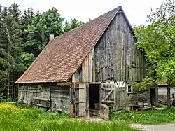 Freilichtmuseum in Rosenfeld | |
 Coat of arms | |
Location of Rosenfeld within Zollernalbkreis district 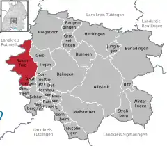 | |
 Rosenfeld  Rosenfeld | |
| Coordinates: 48°17′11″N 08°43′27″E | |
| Country | Germany |
| State | Baden-Württemberg |
| Admin. region | Tübingen |
| District | Zollernalbkreis |
| Subdivisions | 7 Stadtteile |
| Area | |
| • Total | 51.11 km2 (19.73 sq mi) |
| Elevation | 620 m (2,030 ft) |
| Population (2019-12-31)[1] | |
| • Total | 6,347 |
| • Density | 120/km2 (320/sq mi) |
| Time zone | UTC+01:00 (CET) |
| • Summer (DST) | UTC+02:00 (CEST) |
| Postal codes | 72348 |
| Dialling codes | 07428 |
| Vehicle registration | BL |
| Website | www |
History
Rosenfeld became a possession of the County, later Duchy, of Württemberg, which made the town the seat of its own district. In 1808, that district was dissolved and Rosenfeld was assigned to Oberamt Sulz. That district, too, was dissolved in 1938 and Rosenfeld was reassigned to the district of Balingen. Rosenfeld underwent a period of growth after World War II, beginning in the 1950s with new housing to the east of the town, and continuing into the 1980s with more residential, commercial, and industrial areas. Following the 1973 Baden-Württemberg district reform, the town was again reassigned to the newly-formed Zollernalb district. Rosenfeld merged with the towns of Heiligenzimmern and Leidringen on 1 January 1975.[2]
Geography
The township (Stadt) of Rosenfeld is located politically in the Zollernalbkreis district of Baden-Württemberg and physically in the Little Heuberg, part of the Swabian Jura. Elevation above sea level varies in the municipal area from a low of 469 meters (1,539 ft) Normalnull (NN) to a high of 700 meters (2,300 ft) NN.[2]
The Federally-protected Häselteiche and Immerland nature reserves are located within the municipal area.[2]
Coat of arms
Rosenfeld's municipal coat of arms displays a five-petaled, white rose with gold seeds and green sepals on a field of red. This pattern, in use by the town of Rosenfeld since 1372, was approved for official use by the Zollernalb district office on 11 May 1976.[2]
Citations
- "Bevölkerung nach Nationalität und Geschlecht am 31. Dezember 2019". Statistisches Landesamt Baden-Württemberg (in German). September 2020.
- "Rosenfeld". LEO-BW (in German). Baden-Württemberg. Retrieved 4 July 2020.
External links
- Official website
 (in German)
| Authority control |
|---|
Towns and municipalities in Zollernalb district | ||
|---|---|---|
Coat of arms | ||