Royal Kunia, Hawaii
Royal Kunia is a census-designated place (CDP) on the island of Oʻahu in the City & County of Honolulu, Hawaiʻi, United States. As of the 2010 Census, the population of the CDP was 14,525.[1] The area was recorded as the Village Park CDP in prior censuses.
Royal Kunia | |
|---|---|
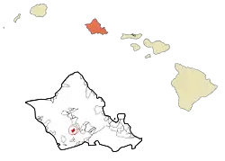 Location in Honolulu County and the state of Hawaii | |
| Coordinates: 21°24′18″N 158°1′54″W | |
| Country | United States |
| State | Hawaii |
| County | Honolulu |
| Area | |
| • Total | 3.0 sq mi (7.8 km2) |
| • Land | 3.0 sq mi (7.8 km2) |
| • Water | 0 sq mi (0 km2) |
| Elevation | 440 ft (130 m) |
| Population (2010) | |
| • Total | 14,525 |
| • Density | 4,800/sq mi (1,900/km2) |
| Time zone | UTC-10 (Hawaii-Aleutian) |
| ZIP code | 96797 |
| Area code(s) | 808 |
Geography
Royal Kunia is located just north of Waipahu at 21°24′18″N 158°1′54″W (21.4052, -158.0318). It is bounded on the south by Interstate H-1 and on the west by Kunia Road (State Route 750).
According to the United States Census Bureau, the CDP has a total area of 3.0 square miles (7.8 km2), all of it land.[2]
Demographics
As of the census[3] of 2010, there were 14,525 people, 4,014 households, and 3,524 families residing in the CDP. The racial makeup of the CDP was 12.5% White, 2.5% African American, 0% Native American, 51.7% Asian, 11.3% Pacific Islander, 0.7% from other races, and 21.7% from two or more races. Hispanic or Latino of any race were 9.5% of the population.
The median income for a household in the CDP was $103,649, and the median income for a family was $91,230. The per capita income for the CDP was $26,900. About 4.8% of families and 2.6% of the population were below the poverty line, including 8% of those under age 18 and 4.3% of those age 65 or over.
Education
Hawaii Department of Education operates public schools. Kale'iopu'u Elementary School is in Royal Kunia CDP.[4][5]
References
- "Profile of General Population and Housing Characteristics: 2010 Demographic Profile Data (DP-1): Royal Kunia CDP, Hawaii". United States Census Bureau. Retrieved May 25, 2012.
- "Geographic Identifiers: 2010 Demographic Profile Data (G001): Royal Kunia CDP, Hawaii". United States Census Bureau. Retrieved May 25, 2012.
- "U.S. Census website". United States Census Bureau. Retrieved 2008-01-31.
- "Home". Kale'iopu'u Elementary School. Retrieved 2020-10-09.
94-665 Kaaholo St. Waipahu, HI 96797
- Royal Kunia CDP (2010): "2010 CENSUS - CENSUS BLOCK MAP: Royal Kunia CDP, HI" (PDF). U.S. Census Bureau. Retrieved 2020-10-09.
Village Park CDP (2000): "CENSUS 2000 BLOCK MAP: VILLAGE PARK CDP" (PDF). U.S. Census Bureau. Retrieved 2020-10-09.
Islands, municipalities, and communities of Honolulu County, Hawaii, United States | ||
|---|---|---|
| CDPs |
|  Map of Hawaii highlighting Honolulu County |
| Other communities |
| |
| ||